Page 1 :
STUDYIO. co Mapping, , MOUNTAIN RANGES 3, , Western Ghat
Page 2 :
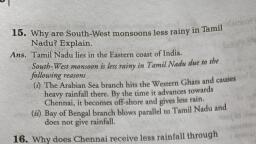
STUDYIO.C0W, , , , Mapping, , Western Ghats (The Sahyadris), , Origin, , The Western Ghats, also known as Sahyadri (Benevolent Mountains), in a stretch of 1,600, kilometres (990 mi) parallel to the western coast of the Indian peninsula, traversing the, states of Kerala, Tamil Nadu, Karnataka, Goa, Maharashtra and Gujarat., , It is a UNESCO World Heritage Site and is one of the eight "hottest hot-spots", of biological diversity in the world., , It is sometimes called the Great Escarpment of India., , The range is known as Sahyadri in Maharashtra and Karnataka. The Western Ghats meet, the Eastern Ghats at the Nilgiri mountains in northwestern Tamil Nadu., , The range runs north to south along the western edge of the Deccan Plateau, and, separates the plateau from a narrow coastal plain, called Konkan, along the Arabian Sea., , The Western Ghats are the mountainous faulted and eroded edge of the Deccan Plateau., , Geologic evidence indicates that they were formed during the break-up of the, supercontinent of Gondwana some 150 million years ago., , Geophysical evidence indicates that the west coast of India came into being somewhere, around 100 to 80 mya after it broke away from Madagascar. After the break-up, the, western coast of India would have appeared as an abrupt cliff some 1,000 m in elevation., , Anamudi is the highest peak of the western ghat in India with elevation 2695m above, MSL and is also the highest point in the south India., , The Western Ghats extend from the Satpura Range in the north, stretching, from Gujarat to Tamil Nadu., , It traverses south through the states of Gujarat, Maharashtra, Goa, Karnataka Kerala and, Tamilnadu., , Major gaps in the range are the Goa Gap, between the Maharashtra and Karnataka, sections, and the Palghat Gap on the Tamil Nadu and Kerala border between the Nilgiri, Hills and the Anaimalai Hills., , The northern portion of the narrow coastal plain between the Western Ghats and, the Arabian Sea is known as the Konkan, the central portion is called Kanara and the, southern portion is called Malabar., , The Western Ghats have many peaks that rise above 2,000 meters,, with Anamudi (2,695 m (8,842 ft)) being the highest peak, , , , 5
Page 3 :
STUDYIQ.C0M Mapping, , South Asia, , , , , , , ts Lanka,, , Western Ghats in India, , , , , , , , , , , , 68°00°E 72°00°E 76°00"E 80°00"E, , z, , 6 z, , 27 °°, , g re, ag, , Dadra & Nagar- Maharashtra, Haveli, , z, , ° z, , 84 5, , ® ro, , t 2, , z=, , S4 z, , = tS, , ~ =, , z P, , zg Kerala Tamil Nadu i, , 27 Ss, , 2] [BJ westem Ghats £, , [AN] State / UT boundary, y T T, 72°00"E 76°00°E 80°00°E, 0 170 «= 340 680 km, rs
Page 4 :
STUDYIQ.COW, , Mapping, , , , , , , , , , , , , , , , , , Central, Western, , Nilgiris, , Southern Western, Ghats, , , , The northern section of Western Ghat, , * The northern section of the Ghats from Tapi valley to a little north of Goa is made of, horizontal sheets of Deccan lavas (Deccan Traps)., , * Thal ghat and Bhor ghat are important passes which provide passage by road and rail, between the Konkan Plains in the west and the Deccan Plateau in the east., , , , 5
Page 5 :
STUDYIO.C0W, , , , Mapping, , The Middle Sahyadri, , This area is covered with dense forests., , The Vavul Mala (2,339 m), the Kudremukh (1,892 m) and Pashpagiri (1,714 m) are, important peaks., , The Nilgiri Hills which join the Sahyadris near the trijunction of Karnataka, Kerala and TN,, rise abruptly to over 2,000 m., , They mark the junction of the Western Ghats with Eastern Ghats., , Doda Betta (2,637 m) and Makurti (2,554 m) are important peaks of this area., , The southern section, , The southern part of the Western Ghats is separated from the main Sahyadri range by Pal, ghat Gap [Palakkad Gap]., , Pal ghat Gap it is a rift valley. This gap is used by a number of roads and railway lines to, connect the plains of Tamil Nadu with the coastal plain of Kerala., , Anamudi (2,695 m) is the highest peak in the whole of southern India., , Three ranges radiate in different directions from Anai Mudi. These ranges are, the Anaimalai (1800-2000 m) to the north, the Palani (900-1,200 m) to the north-east, and the Cardamom Hills or the Ealaimalai to the south., , Western Ghats (The Sahyadris), , Rivers originated from Western Ghat:, , The Western Ghats form one of the four watersheds of India, feeding the perennial rivers, of India., , The major river systems originating in the Western Ghats are, the Godavari, Kaveri, Krishna, Thamiraparani and Tungabhadra rivers. ., , These rivers flow to the east due to the gradient of the land and drain out into the Bay of, Bengal., , Major tributaries include the Bhadra, Bhavani, Bhima, Malaprabha, Ghatprabha,, Hemavathi and Kabini rivers., , , , 5