Page 1 :
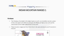
STUDYIO Mapping, , MOUNTAIN RANGES 2, , Mountain ranges of Central India
Page 3 :
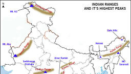
STUDYIQ.COM, , , , QuickGs, Mountain Ranges of India, , , , Aravalli Range, , Aligned in north-east to south-west direction, Aravalli range run for about 800 km, between Delhi and Palanpur in Gujarat., , They are one of the oldest (very old) fold mountains of the world and the oldest in India., After its formation in Archaean Era (several 100 million years ago, its summits were, nourishing glaciers and several summits were probably higher than the present day, Himalayas., , Now they are relict (remnants after severe weathering and erosion since millions of, years) of the world’s oldest mountain formed as a result of folding (Archaean Era)., , They continue up to Haridwar buried under the alluvium of Ganga Plains., , The range is conspicuous in Rajasthan (continuous range south of Ajmer where it rises to, 900 m.) but becomes less distinct in Haryana and Delhi (characterized by a chain of, detached and discontinuous ridges beyond Ajmer)., , , , 5
Page 4 :
STUDYIO.C0W, , , , Mapping, , According to some geographers, one Branch of the Aravalli extends to the Lakshadweep, Archipelago through the Gulf of Khambat and the other into Andhra Pradesh and, Karnataka., , Mt. Abu (1,158 m), a small hilly block, is separated from the main range by the valley of, the Banas. Guru Sikhar (1,722 m), the highest peak, is situated in Mt. Abu., , Pipli Ghat, Dewair and Desuri passes allow movement by roads and railways., , Satpura Range, , Satpura range is a series of seven mountains (‘Sat’ = seven and ‘pura’ = mountains), , It runs in an east-west direction south of the Vindhyas and in between the Narmada and, the Tapi, roughly parallel to these rivers., , It stretches for a distance of about 900 km., , Parts of the Satpuras have been folded and upheaved. They are regarded as structural, uplift or ‘horst’., , Dhupgarh (1,350 m) near Pachmarhi on Mahadev Hills is the highest peak., , Amarkantak (1,127 m) is another important peak., , Vindhya Range, , The Vindhya Range, overlooking (have a view of from above) the Narmada valley, rises as, an escarpment (a long, steep slope at the edge of a plateau or separating areas of land at, different heights) flanking (neighboring on one side) the northern edge of the Narmada, Son Trough (the rift through which the Narmada river flows) (trough is opposite of ridge., , It is a narrow depression)., , It runs more or less parallel to the Narmada Valley in an east-west direction from Jobat in, Gujarat to Sasaram in Bihar for a distance of over 1,200 km., , The general elevation of the Vindhya Range is 300 to 650 m., , Most parts of the Vindhaya Range are composed of horizontally bedded sedimentary, rocks of ancient age. {Rock System}, , The Vindhyas are continued eastwards as the Bharner and Kaimur hills., , , , 5
Page 5 :
STUDYIQ.CON Mapping, * This range acts as a watershed between the Ganga system and the river systems of south, India., , * The rivers Chambal, Betwa and Ken rise within 30 km of the Narmada., , Kaimur Range, , * Kaimur Range is the eastern portion of the Vindhya Range, about 483 kilometres (300 mi), long, extending from f Madhya Pradesh to Bihar., , * The southern part of the Vindhyan Range up to Katangi is called Bhander Range. Beyond, this point the escarpment enclosing the land-locked valley of Sirampur and the hill range, in continuation is called the Kaimur Range., , * This forms the watershed or divide for two of the major rivers of peninsular India,, the Son on the south and Tamsa or Tons on the north., , , , , , , , 5