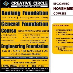
Notes of General Foundation, All Subjects Geography Creative Circle Material - Study Material
Page 1 :
PHYSICAL GEOGRAPHY, , CONTENTS, , CONTENT, , PART – I (PHYSICAL GEOGRAPHY), CHAPTER, , PAGE, , 1. SOLAR SYSTEM, , 1-3, , 2. MOTION OF THE EARTH, , 3-4, , 3. INTERIOR OF THE EARTH, , 4-5, , 4. EARTHQUAKE AND SEISMIC WAVES, , 5-7, , 5. VOLCANIC ACTIVITY, , 7-8, , 6. CONTINENTAL DRIFT THEORY, , 8-10, , 7. MINERALS, , 10-11, , 8. ROCKS, , 11-12, , 9. GEOMORPHIC PROCESSES, , 12-14, , 10. COMPOSITION OF ATMOSPHERE, , 14-15, , 11. SOLAR REDIATION, , 15-17, , 12. PRESSURE AND WINDS IN ATMOSPHERE, , 17-19, , 13. CLIMATE CHANGE, , 19-22, , 14. WATER IN ATMOSPHERE, , 22-23, , 15. MOVEMENT OF OCEAN WATER, , 23-25, , 16. STRUCTURE AND COMPOSITION OF BIOSPHERE, , 25-26, , 17. DISASTER MANAGEMENT, , 26-31, , 18. AVALANCHE DISASTER, , 31-32, , PART – II (PHYSICAL GEOGRAPHY), 1. PHYSIOGRAPHY OF INDIA, , 34-36, , 2. SOIL, , 36-37, , 3. DRAINAGE, , 37-40, , 4. NATURAL VEGETATION, , 40-41, , 5. CLIMATE OF INDIA, , 41-42, , 6. CROPS IN INDIA, , 42-43, , 7. LANSLIDE IN INDIA, , 43-44, , 8. WETANDS IN INDIA, , 44-45, , 9. POPULATION IN INDIA, , 45-47, , 10. MICA, LIMESTONE & OTHER NON-METALLIC MINERIALS IN INDIA, , 47-51, , 11. TRANSPORT, , 51-57, , 12. INDUSTRY OF INDIA, , 57-58, 0|P a g e, , CREATIVE CIRCLE Konung Mamang Wangkhei Road Near Traffic Point
Page 2 :
PHYSICAL GEOGRAPHY, Chp-1: Solar System, We live on the planet named ‘Earth’. Likewise, Earth also, exists in its home with other 7 planets, only star ‘Sun’, and many other small objects called asteroids, comets,, dwarf planets, meteors etc. So basically the Solar system, is a system of Sun, 8 planets, dwarf planets, asteroids,, meteors and comets under the gravitational influence of, the Sun., Origin, There are 3 to 4 major theories of the evolution of the, universe and ultimately of the solar system. The, prominent theory among all of these is Big Bang theory., According to this theory proposed by Georges Lemaitre,, the universe is evolved from a small singularity and then, expands over the next 13.8 billion years and still, expanding., It led to the formation of many billions of galaxies, solar, systems, stars etc., Our solar system lies in a spiral-shaped galaxy called, ‘Milky Way’. The nearest galaxy to us is ‘Andromeda’., Generally, there is a Black hole at the centre of every, galaxy. ‘Sagittarius A’ is the black hole at the centre of, Milky Way., Solar System, In our solar system, 8 planets and many other celestial, bodies revolve around the sun in elliptical orbits., The dwarf planet named Pluto was removed from the list, of the planets by the International Astronomical Union in, 2006., Sun is the powerhouse of the solar system. It is the only, source of energy in the solar system., Planet Mercury is nearest to the sun while Neptune is, the farthest planet from the sun., There is an asteroid belt between Mars and Jupiter., Planets inside the belt are distinctly different from those, outside in terms of size, mass, and composition etc., Planets inside the belt are called as Terrestrial planets, and they are Mercury, Venus, Earth, and Mars. Planets, outside the best are called as Jovian planets and they are, Jupiter, Saturn, Uranus, and Neptune., Terrestrial planets are nearer to the sun, with metallic, minerals and rock crust, with a thin atmosphere and, have less number of natural satellites. While Jovian, planets are away from Sun, made up of hot gases, have, rings around them, and have a large number of natural, satellites., Facts about Sun and Planets, 1. Sun, The only star in our solar system and powerhouse of the, solar system., Composed of Hydrogen (73%), Helium (25%) gases and, other metals. Sun carries almost 99% mass of our solar, system., , Approximately 15 crore Kilometres further away from, Earth. It takes around 8 minutes 30 seconds for light at, the speed of 3 lakh Km/sec to reach the earth., Temperature at surface= 5800 K or 5600 degree Celsius., Temperature at the centre= 15.7 million K, 2. Mercury, Closest planet to the Sun and very hot planet., Smallest planet in the solar system with a diameter of, 4900 Km., Fastest Planet with speed of 172500 Km per hour to, complete revolution around Sun in 88 days., The planet with no water and gases like Nitrogen,, Hydrogen, Oxygen and Carbon Dioxide., 3. Venus, Hottest planet in the solar system with the surface, temperature of 478 degree Celsius., Also known as “Earth’s Twin”. It is because of similarity, in size and mass between Venus and Earth., One of the two planets in the solar system which rotate, around the axis in a Clockwise direction., Brightest Star in the Solar system. It can be seen in, morning and evening with open eyes. So known as, “Evening Star” and “Morning Star”., 4. Earth, The only Planet to give support to life with a pleasant, atmosphere., Also known as “Blue Planet” because of the presence of, water on it., It has one natural satellite named “Moon”., 5. Mars, Known as “Red Planet” because of Iron-rich red soil., Second smallest planet in the solar system after, Mercury., Has two natural moons “Phobos” and “Deimos”., Has thin atmosphere and surface with val, leys, craters, deserts and ice caps etc., “Olympus Mons” – Largest volcano and the tallest, mountain in solar system lies on Mars., 6. Jupiter, Largest planet of the solar system with the shortest, rotation, Has atmosphere filled with Hydrogen, Helium and other, gases, The third brightest object in the night sky after the Moon, and Venus., Great Red Spot, a giant storm in the solar system exists, on this planet., Has at least 69 moons, including 4 large Galilean Moons, “Io, Europa, Ganymede, and Callisto” which were, discovered by Galileo. “Ganymede” is the largest among, them., It has an unclear ring around it., , 1|P a g e, CREATIVE CIRCLE Konung Mamang Wangkhei Road Near Traffic Point
Page 3 :
PHYSICAL GEOGRAPHY, , 7. Saturn, Second largest planet in the solar system and a gas giant., Has bright and concentric rings around it which are, made up of tiny rocks and pieces of Ice., Saturn can float on water because it has less density, than water., Has at least 62 moons and Titan is the largest among, them., 8. Uranus, Has the third- largest planetary radius and fourth largest, planetary mass in the Solar system., Greenish in colour., Discovered by William Herschel in 1781., Known as “Ice Giant”. The atmosphere of Uranus is, composed of Hydrogen and Helium primarily, but it also, contains more water, ammonia etc., Has coldest planetary atmosphere in the solar system., Rotates clockwise on its axis like Venus but unlike other, planets, Has at least 25 moons. Famous moons- Miranda, Ariel, and Umbriel, 9. Neptune, Farthest planet from the Sun., It is also “Ice Giant”. Atmosphere primarily composed of, Hydrogen and Helium., Bluish in colour because of Methane., Fourth largest planet and the third most- massive planet, in the solar system, Discovered by Johann Galle and Urbain Le Verrier in, 1846. The only planet in the solar system found by, Mathematical Predictions., Has known 14 satellites. Famous moon – Triton., 10. Pluto, As per the new definition of Planets determined by, International Astronomical Union (IAU), Pluto has been, omitted from the list of planets in 2006., Pluto is considered as a dwarf planet (size between, planets and asteroids) now and it is a member of Kuiper, Belt., Kuiper Belt is a spherical boundary outside the orbit of, Neptune containing a number of asteroids, rocks, and, comets., Other Space Objects, 1. Asteroids, These are small objects; rocks (mostly debris) revolve, around the Sun., They are mostly found in the Asteroid Belt which lies, between the orbits of Mars and Jupiter., These are also known as Minor planets., Ceres, Vesta, Psyche are some famous and largest, asteroids in the solar system., , 2. Meteors and Meteorites, These are also known as Shooting stars., Meteors are the small-sized rocky material which is, generally formed due to asteroid collision and, approaching the earth., Because of Earth’s atmospheric layers, these small rocks, burn before reaching the surface., But there are some meteors which do not burn, completely and land on Earth’s surface. They are called, as Meteorites., Willamette, Mbozi, Cape York, and El Chaco are some, meteorites found on the Earth., Lonar lake, Maharashtra in India is supposed to be, created by a meteor impact in Pleistocene Epoch., 3. Comets, These are shiny, luminous “Tailed Stars”. These are rocky, and metallic materials surrounded by frozen gases., These are generally found in Kuiper Belt. They travel, towards the Sun., Their tail faces opposite of the sun and head faces, towards the Sun., They become visible when they travel close to the Sun., Halley comet is famous which appeared last time in 1986, and which reappears after every 76 years., Solar and Lunar Eclipse, An eclipse is the partial or total blocking of the light of, one object by another. In the solar system, relative, positions of the Sun, Moon, and Earth create solar, eclipses and lunar eclipses., Frequency of Eclipses, Perfect alignments of the Sun, Moon, and Earth are, relatively uncommon, because the plane of Earth’s orbit, around the Sun (ecliptic plane) is not the same as the, plane of the Moon’s orbit around Earth. Thus, during, the new moon or full moon phases when an eclipse, might be possible, the Moon is usually located just above, or below the straight line that runs between Earth and, the Sun, so no eclipse occurs. All three bodies viz. Earth,, Moon, and Sun line up just right about twice a year., Lunar Eclipse, A lunar eclipse occurs when Earth passes between the, Sun and the Moon in such a way that the Moon moves, into Earth’s shadow. When a partial lunar eclipse is going, on, the curved shadow of our planet is apparent on the, Moon’s face; the Moon looks kind of like it is in a, crescent phase, but the terminator line (the line, between light and dark) is not curved the same way., When a total lunar eclipse is happening, the entire Moon, is in Earth’s shadow, and the Moon looks full, but glows, only faintly red. Why?, The reason is as follows: Earth’s atmosphere is dense, enough to act a little bit like a lens, so it refracts a small, amount of sunlight shining through it toward the Moon., , 2|P a g e, CREATIVE CIRCLE Konung Mamang Wangkhei Road Near Traffic Point
Page 4 :
PHYSICAL GEOGRAPHY, This small fraction of light, which is mostly red because, that is the color of light that refracts best, bounces off, the Moon’s surface and comes back to Earth. Before and, after totality, the direct sunlight reflected off the Moon, is so strong by comparison that it drowns out this, refracted light, so we normally cannot see it with our, unaided eyes. During totality, however, the Earthatmosphere-refracted light is quite visible as a soft, reddish glow., , distance from Earth is also just under 400 times smaller, than the Sun’s distance from Earth. That is why the, Moon covers almost exactly the same amount of sky,, when viewed from Earth’s surface, as the Sun. We are, able to see only Corona during Total solar eclipse., , Solar Eclipse, A solar eclipse happens when the Moon is directly in line, between Earth and the Sun. The Moon’s shadow sweeps, across Earth’s surface; at those places where the shadow, lands, an eclipse is seen., Like Earth’s shadow, the Moon’s shadow consists of two, parts: a dark, central region called the umbra, and a, lighter region called the penumbra that surrounds the, umbra. Under the penumbra, a partial solar eclipse, occurs. Under the umbra, a total eclipse or an annular, eclipse is seen., Since the Moon travels in a slightly elliptical orbit around, Earth, rather than in a perfectly circular path, its distance, from Earth is not always the same. If the Moon’s umbra, falls on Earth’s surface when the two bodies are at a, closer point in the Moon’s orbit, there is total solar, eclipse. But if the Moon happens to be too far away, from Earth at that time, the Moon does not cover, enough of the sky to block the Sun’s rays entirely. In that, case, the Sun is seen as a ring, or annulus, of light, glowing around the silhouette of the Moon., During totality of a solar eclipse, the Sun looks like a, perfectly black disk surrounded by glowing light. This, light is actually the Sun’s corona, which is invisible under, normal circumstances because the Sun is so bright. Away, from the corona, the sky is dark, so planets and stars, that ordinarily could be seen only at night become, visible., Frequency of Solar Eclipse at a particular location on, earth, The entire process of a solar eclipse, from the beginning, of partial coverage until the end, usually takes about an, hour. However, the totality of solar eclipse lasts at most, only a few minutes. Most total solar eclipses last, between 100 and 200 seconds— just about two to three, minutes. Furthermore, total solar eclipses can be, observed only from narrow bands on Earth’s surface,, and these bands change with each eclipse. In any given, location on Earth, therefore, a total solar eclipse may, appear only once every few centuries., Why Moon blocks Sun so perfectly during solar eclipse?, The Moon’s diameter is just under 400 times smaller, than the diameter of the Sun. Coincidentally, the Moon’s, , 3|P a g e, CREATIVE CIRCLE Konung Mamang Wangkhei Road Near Traffic Point
Page 5 :
PHYSICAL GEOGRAPHY, , Chp-2: Motion Of The Earth, The Earth shows two types of motions which leads to, seasons and day-night patterns. These motion are –, rotation around its own axis and revolution about the, Sun., Rotation – The movement of the earth on its axis., The Earth rotates from the west towards theeast., Around 500 BC, Aryabhatta deduced by his, calculations that the Earth is spherical androtates, about its axis., Revolution – The movement of the Earth around the, Sun in a fixed path or orbit is calledRevolution.This, movement causes seasonal variations in different, parts of the Earth. It takes365 days 6 hours to, revolve around the Sun., Elliptical orbit: The earth moves around the sun in an, elliptical orbit., Inclination of Earth never changes: Throughout its orbit,, the earth is inclined in the same direction., , There are a few terms associated with these, movements, which are essential for complete, understanding of the concepts involved in sesonality and, Time descriptions regarding the Earth., Circle of Illumination – Earth is spherical in, shape,which leads to half of the sphere, beingexposed to the sunrays at a time and other half, being in the dark. As a result of this, one half of, Earth experiences Day and another half experiences, Night. Now, this circle which divides the day and, night on Earth is known as the Circle of illumination., Notably, this circle does not coincides with the Axis, of Earth., Seasons – Earth is tilted on its axis, this means that, different parts of Earth receive differentamount of, sunlight. Such a situation when*box type=”info”, align=”aligncenter” +Earth is tilted with 66 1/2 angle, with the Orbital Plane-The axis of the earth which is, an imaginary line, makes an angle of 66 1/2 with its, orbitalplane.[/box]occurs along with the regular, rotation of Earth, causes the occurance of, variousseasons across the globe. Southern, , , , , , , , hemisphere receives different season than the, Northernhemisphere:, o On 23rd Sept. it is autumn season in the, Northern Hemisphere and spring season in, theSouthern Hemisphere., o The opposite happens on 21st March, when it is, spring in the Northern Hemisphere andautumn, in the Southern Hemisphere., Leap year – Six hours are saved every year from the, time period of a year. In four years, theseare, combined to make a day and under the georgian, calender , it is added to the February 29.such a year, has 366 days compared to the 365 days of normal, year., Summer Solistice – It happens on June 21st of every, year. The Longest day and Shortestnight is observed, in the Northern Hemisphere. This occurs because, the Northern Hemisphereis inclined towards the Sun, with the North pole pointing towards the Sun., Therefore, theSunrays fall directly over the Tropic of, Cancer., A, large, portion, of, Northern, Hemispherereceives light from the Sun, hence it is, summer in the regions of this hemisphere. But, in, theSouthern Hemisphere, the region experiences, winter season with longer nights than the days., , Winter Solistice – This happens on December 22nd, of each year. The Northern Hemisphere observes, shortest day and Longest Night. Whereas, the, Southern Hemisphere experiences Longest day and, Shortest night. This happens because the South pole, is inclined towards the Sun with the Southern, Hemisphere receing maximum sunlight, hence, it is, summer season in the southern hemisphere but, winter season in the northern hemisphere.This, position of the Earth is known as Winter Solistice., Equinox – It occurs twice a year. Once on March, 21st and again on September 23rd. Whendirect, sunrays fall over the equator, maximum sunlight is, received by the equatorial region.This results in, equal length of day and night over all of Earth. At, this position, none of thepoles are tilted or inclined, towards the Sun. This is known as Equinox., Perihelion – It occurs on January 3rd. While in orbit ,, when Earth is closest to the Sun, whichmeans then, Earth is at minimum distance from the Sun., 4|P a g e, CREATIVE CIRCLE Konung Mamang Wangkhei Road Near Traffic Point
Page 6 :
PHYSICAL GEOGRAPHY, , , Aphelion – This occurs on July 4th every year. While, the Earth orbits around the Sun and ispositioned at, maximum distance from the Sun, that position is, called aphelion., , Chp-3: Interior of the Earth, It is given fact that the radius of earth is 6,370 km., Therefore, the interior of Earth cannot be studied only, by direct observations. But its properties are studied, indirectly by deducing conclusions from the study of, earthquake waves that propagate through the interior, rocks and other such indirect means., Configuration of surface of earth is a product of exogenic, and endogenic processes in earth. It is the endogenic, processes that determine the interior configuration of, earth., , 4. Magnetic surveys: The distribution of magnetic, materials gives idea of magnetic field of earth which, indicates densitytand type of material present in the, interior of earth., 5. Sesmic activity: This gives most important evidences, of interior of earth. Earthquakes give a fair idea of, interior of earth. We shall look into the details of, Earthquake laters on., Structure of Earth, , Sources of study of interior of earth:, I. Direct sources –, 1. Deep ocean drilling reveals humongous information, through analysis of materials collected atdifferent, depth., 2. Volcanic eruption deliver information by the means, of molten magma that comes out of Earth’s interiors., But, its difficult to determine the depth of such, magma’s origin., 3. Surface rocks are readily available earth material., 4. Gold mines go to a depth of 5 km on an average,, these serve as good opportunities for studying the, depths of earth., II. Indirect sources –, 1. Temperature and pressure patterns through mining, activity : An increase in temperature andpressure with, depth means an increase in density as well. Hence it, becomes possible to determine the rate of change of, characteristics of material of earth. This has lead to, the, knowledge of the layers of earth., 2. Meteors : These are extra-terrestrial masses, reaching the earth’s surface. They have material and, structure similar to earth and give information about, the materials of which earth is formed of., 3. Gravitation force(g) : The force exerted by the Earth, on all things in its range is not same along all, lattitudes, it is variable over different places., Observations suggest that gravitational force is greater, at poles, and lesser at equator. This is due to increased, distance from the core. This difference in (g) is also, attributed to the uneven material mass distribution., , I. The Crust:, It is the outermost solid and brittle part of the Earth., Oceanic crust is thinner – 5 km mean thickness. It is, made up of heavier rocks like basalt. Themean, density of material here is 2.7 g/cm3 ., Continental crust is thicker – 30 km mean thickness., The mean density of material here is 3g/cm3., Upper crust is known as SIAL and lower crust is, known as SIMA., *box type=”info” align=”aligncenter” +Himalayan crust is, 70 km thick since the continental crust is usually thicker, in mountaineous areas.[/box], II. The Mantle:, The portion of interior of crust is called mantle. It, extends from Moho’s discontinuity to 2,900 km., The upper part of mantle is called – Asthenoshpere., “Asthen” means weak. It extends upto 400 km and it is, the main source of magma. Lithosphere is the crust and, uppermost solid part of the mantle. It has thickness in, range of10-200km. The lower mantle extends beyond, aesthenosphere and remains in the solid state. It should, be noted here that the mantle has higher density than, the crust., III. The Core:, The composition of this layer was understood by, studying the Earthquake waves. It is liquid onthe, outer side, but the inner core is solid., The density of core towards mantle to centre is in, the range of 5- 13 g/cm3., , 5|P a g e, CREATIVE CIRCLE Konung Mamang Wangkhei Road Near Traffic Point
Page 7 :
PHYSICAL GEOGRAPHY, , , It is constituted by very heavy materials, primarily, Nickel and Iron. Therefore, it is also calledthe ”, nife” layer., , Geological Time Scale, Geological time scale is a system of chronological, measurement of time, and it is usually referred by Earth, scientists to describe the timing and the relationships, between events that have occurredthroughout Earth’s, history since its inception. There are few specific words, used in this time scale which should be explained for, better understanding of the time scale., Eon > Era > Period > Epoch > Age is the descending, order of time scale used to describe thegeological, time history., The ongoing Epoch is Holocene, it is also known as, the age of Human beings., , 6|P a g e, CREATIVE CIRCLE Konung Mamang Wangkhei Road Near Traffic Point
Page 8 :
PHYSICAL GEOGRAPHY, , Chp-4: Earthquake and Seismic Waves, The study of seismic activity gives valuable information, about the interior structure of the Earth. Earthquake is a, natural event and involves shaking of the ground. A, thorough study and observations of this phenomenon, has helped in understanding of innermost parts where, this occurs. An Earthquake is the shaking or, vibration/tremors in the Crust, caused as a result of, internal forces and vulcanism in the Earth., Measurement:, All earthquakes are different in their intensity and, magnitude. The instrument for measurement of the, vibrations is known as Seismograph., 1. Magnitude scale: Richter scale. Energy released, during a quake is expressed in absolute numbers of 0-10., 2. Intensity scale: Mercalli scale. It measures the visible, damage caused due o the quake. It is expressed in the, range of 1-12., , Causes of earthquake:, It is caused due to release of energy from faults and, fractures in the Earth’s crust. A fault in earth’s crust is, basically a sharp break in crustal rocks.This energy, release generates waves which travel in all directions., The point where energy is released is called the focus /, hypocenter. It is generally located at the depth of 60 km., The point on surface where the energy waves reach the, surface is called the epicenter. The earthquake waves, travel in all directions, but they have highest intensity at, the epicenter. Hence they cause maximum damage, there. The intensity of Earthquake decreases as one, moves away from the epicentre., , Earthquake or Seismic Waves:, These waves occur in lithosphere, i.e. up to 200 km of, depth from the surface of Earth. These waves are, recorded on a seismograph. It shows different types of, waves. There are two type of waves:, A) Body waves; B) Surface waves., Body waves are generated by the energy released at, the focus /hypocenter. They move in alldirections, through the body of Earth. They interact with the, surface rocks and generateSurface waves, which, move along the surface. Body waves are further, divided in two types: P –waves and S – waves., Surface waves move along the surface.The velocity, of these waves vary with the materialthrough which, they travel, the more denser the material, the higher, the velocity of thesewaves. They change their, direction as they reflect and refract after coming, across materials ofdifferent densities., , Let us look into the characteristics of each of these, waves in brief. The following are points from standard, textbook so they are reliable source for study and, revision:, 1. P- waves:, These waves are known as Primary waves as they, are first one to arrive at the surface., Their characteristics are similar to Sound waves, as, they travel through all three mediums- solid, liquid, and gases., , 7|P a g e, CREATIVE CIRCLE Konung Mamang Wangkhei Road Near Traffic Point
Page 9 :
PHYSICAL GEOGRAPHY, , , , , , , P-waves have a tendency to vibrate parallel to the, direction of wave propagation. this causesdensity, differences in the material through which they, travel., These waves are responsible for stretching and, squeezing of material., Shadow zone: these are specific areas where waves, are not reported on the seismograph. P-waves, appears as around the Earth at 105-145 degrees, away from the epicenter., , 2. S- waves:, These waves arrive after some time delay, hence, they are called secondary waves., An important characteristic of these s-waves is that, they travel only through solid medium.This is, important because this information helped in, understanding the structure of interior ofEarth., The direction of vibration of these S – wave is, perpendicular to the direction of wavepropagation,, thereby creating crests and troughs in material of, their transmission., Shadow zone: Beyond 105 degrees from the, epicenter no S-waves are reported., , How Tsunami works., It is a Japanese term which means” harbour waves”., These are waves generated by the tremors and, vibration, of, earth., These, are, not, earthquakethemselves but an effect of earthquake., Occurrence: When the epicenter of an earthquake is, below the oceanic waves and magnitudeof the, quake is above 5 on the Richter scale., , Chp-5: Volcanic Activity, A Volcano is basically an opening in the Earth’s crust, through which heated, materials usually in form of magma, are ejected out to the surface of Earth., Volcanism: It is the activity of eruption or ejection of, molten rock on the surface of Earth from an opening called, vent., Magma: It is molten rock within the Earth’s crust. Magma is, what is present inside a volcano in the “magma chamber”., Magma is generally located in aesthenosphere zone of, mantle under the Earth’s crust., Lava: When magma reaches the surface, it is known as, Lava. This is what comes out from a volcano. The area on, which it moves is called “lava flow”. Lava has various forms, – thick and slow moving or thin and fast moving. Other, materials that come out of a volcano are – ash, fragments, of rocks, gases, water, cinders (bits of fragmented lava),, pumice (light-weight rock having abundant air bubbles),, pyroclastic debris, volcanic bombs and dust etc., , I. Volcanoes are classified on the basis of their, periodicity of eruption in three types:, 1. Active volcano – If gases, ashes, or lava are being, released or have been released by a volcano in recent, past. Examples, Etna, Stromboli, Pinatubo, etc. India has, no active volcano., 2. Dormant volcano – Those volcanoes which have not, shown activity in past years but has possibility of, erupting again. These are considered “sleeping, volcanoes” since they have probability of waking up, again. Examples are – Barren island volcano in Andaman., 3. Extinct volcano – these volcanoes have not erupted in, past 10,000 years and hence their probability of erupting, again is not significant in comparable time-scale., Example,, II. Volcanoes are also classified based upon their mode, of eruption:, , 8|P a g e, CREATIVE CIRCLE Konung Mamang Wangkhei Road Near Traffic Point
Page 10 :
PHYSICAL GEOGRAPHY, 1. Hawaiian type eruption – These volcanoes erupt, quietly with thin lava and little amount of gas. As the, name suggest they are found in Hawaiian islands., 2. Strombolian type eruption – These volcanoes erupt in, a rhythmic fashion with regular interval of time. These, are located in the Lipri islands near Italy (Also known as, “lighthouse of the Mediterranean), , 3. Vulcanian type eruption – These volcanoes erupt with, high intensity and force. They have viscous lava which, solidifies quickly resulting in a cauliflower like cloud at, eruption. Mt. Vulcano of Lipari island of Mediterranean, sea., 4. Pelean tyoe eruption – These volcanoes are very, explosive in their eruption with very viscous, gas rich,, lava which plugs the vent of volcano making it violent. It, is named ” Nuee Ardente” due to its tendency to spread, down the slope. It is found in Martinique island in the, Carribean sea, and Krakatau volcano amidst Java and, sumatra in Sunda strait., III. Classifies on the basis of form developed at the, surface volcanoes are described as:, 1. Shield Volcanoes : These are largest of all volcanoes, after basalt flows. These are made up of basalt which is, very thin fluid. Thats why these volcanoes are not steep, as their lava spreads out. These are known to form, Cinder Cone. Example, Hawaiian volcanoes., 2. Flood Basalt Provinces: These volcanoes eject highly, fluid lava which flows for long distances. This can be due, to deeply seated magma chamber which heats up the, magma to a great extent. The lava flows from this type, of volcano spreads to hundreds of kilometres. Example,, Deccan traps of indian peninsula which cover the, Maharashtrian plateau are flood basalt provinces., 3. Composite Volcanoes: These volcanoes release cooler, and more viscous lava than basalt in an explosive, manner. Usually pyroclastic material and ashes are also, released along with lava. Since their lava is viscous it, forms layers as it cools off, hence forming a composite, structure., Examples, Mt. Fuji, Mt. Rainier in washington., 4. Caldera : These are most explosive volcanoes with wet, granitic magma which rises up quickly. These are so, explosive that they collapse on themselves( such, , explosiveness means that their magma chamber is in, close vicinity) rather than building any tall structure. This, collapsed depression is known as caldera. examples, lake, Toba in Indonesia , Yellowstone in Wyoming- USA., 5. Mid-Oceanic Ridges : These volcanoes occur on Ocean, floor stretching more than 70,000 kmlong along all the, ocean basins. These are the longest mountain chain on, the surface of earth. It has a central rift which, experiences intense eruptions., , Chp-6: Continental Drift Theory, Continents cover 29 percent of the surface of the earth, and remainder is under oceanic waters. Alfred Wegner, was a German meteorologist who put forth the, Continental Drift Theory in 1912., , It is considered that there was a single landmass called, PANGAEA- which means all earth. The mega-ocean is, called PANTHALASSA – which means all water., The basic argument was that – About 200 million years, ago, the mega-landmass PANGAEA started splitting into, two large landmasses namely, LAURASIA in the north, and GONDWANALAND in the south. These two, landmasses kept splitting till they they reached present, configuration of continents and oceans., , 9|P a g e, CREATIVE CIRCLE Konung Mamang Wangkhei Road Near Traffic Point
Page 11 :
PHYSICAL GEOGRAPHY, The argument for the Continental Drift Theory gets, strength from the following evidences:, o, 1. Matching of Continents in a Jig-Saw-Fit: The, shorelines of Africa and South America towards each, other show a remarkable match., 2. Rocks of same age across the oceans: It is established, by radiometric dating methods that the earliest marine, deposits along the coastline of south america and Africa, are of Jurassic age, this suggest ocean did not occur prior, to that. A belt of ancient rocks of 2,000 million years, from Brazil coast matches with those from Western, Africa., 3. Tillite: It is sedimentary rock formed out of deposits of, glaciers. Gondwanaland system of sediments has its, counterparts in six differentlandmasses of Southern, , Hemisphere. Thick tilliation at base shows prolonged, glaciation. Counterparts of this succession are found in, Africa, Falkland island, Madagascar , Antarcticaand, Australia besides India. It proves paleoclimates and, drifting of continents. These landmasses have similar, histories., 4. Placer deposits : Occurrences of rich placer deposits, of gold in Ghana coast and the absolute absence of, source rock in the region. Also, presence of gold bearing, veins in Brazil show that obviously gold deposits of, Ghana are derived from Brazilian plateau when they, were together., 5. Distribution of fossils: Lemurs occur in India,, Madagascar, and Africa, this informationleads to, consideration of these three landmasses being, connected in the past, hypothetically named” Lemuria”., Also Mesosaurus (a small reptile living in brackish water), skeleton have been found only in two localities – South, Africa and Iraver formation of Brazil, which are 4,800 km, apart presently., According to Wegener, forces responsible for this, Continental drifting are:, 1. Pole-fleecing force – rotation of earth., 2. Tidal force – This is due to attraction of moon and the, sun that develops tides in oceanic waters., Post drift studies have shown some progress with, following noteworthy points:, o Convectional current Theory: Arthur Holmes in, 1930s discussed the possibility ofconvection, currents operating in the mantle portion. These, , currents are generated dueto radioactive elements, causing thermal differences in the mantle portion., Mapping of the oceanic floor: Dating of rocks from, oceanic crust reveal that they aremuch younger, than continental areas., , Plate Tectonics, , Tectonic plate/ lithospheric plate is a massive ,, irregularly shaped slab of solid rock , generallycomposed, of continental and oceanic lithosphere. Plates move, horizontally over the aesthenosphere as rigid units., these can be called oceanic or continental based on, which area, is major on the plate. Theory of plate tectonics proposes, that – Earth lithosphere is divided into seven major and, some minor plates., 1. Antarctica and surrounding oceanic plate, 2. North America ( western Atlantic floor separated, from South America along Caribbean islands) plate, 3. South American ( with western Atlantic floor, separated from North American plate along Caribbean, islands) plate, 4. Pacific plate, 5. India- Australia-New Zealand plate, 6. Africa with eastern Atlantic floor plate., 7. Eurasia and adjacent oceanic plate., These plates have been constantly moving over globe, throughout the history of earth. Continents are part of a, plate and what moves is the plate. This is in not sync, with what Wegener said, he said continents move. [box, type=”info” align=”aligncenter” +Position of peninsular, India is traced from rocks found in Nagpur area. [/box], Minor plates:, 1. Cocos plate- between central america and pacific, plate., 2. Nazca plate – between south america and pacific, plate., 3. Arabian plate – Mostly Saudi Arabian landmass., 4. Philippine plate – between Asiatic and Pacific plate., 5. Caroline plate – between the Philippine and Indian, plate, , 10|P a g e, CREATIVE CIRCLE Konung Mamang Wangkhei Road Near Traffic Point
Page 12 :
PHYSICAL GEOGRAPHY, 6. Fuji plate – North-east of Australia., , Plate boundaries, There are three type of plate boundaries :, , 1. Radioactive decay, 2. Residual heat, The slow movement of hot, softened mantle that lies, below the rigid plates is the driving force behind the, plate movement., , Chp-7: Minerals, 98% of Earth’s crust is made up of 8 elements, namely:, , I. Divergent boundaries:, o New crust is generated as plates pull away from, each other., o Sites of pulling away : Spreading sites. Example, MidAtlantic Ridge, at this theAmerican Plate is /are, separated from the Eurasian and African Plates., II. Convergent Boundaries:, o Where crust is destroyed as one plate dived under, another., o The location where sinking of plate occurs isSubduction zone., o Three ways of convergence are: a) between oceanic, and continental plate; b) betweentwo oceanic, plates; c) between two continental plates., III. Transform Boundaries:, o Crust is neither produced, nor destroyed as the, plates slide horizontally past each other., o Transform faults are the planes of separation, generally perpendicular to mid-oceanicridges., o Since eruption is irregular, differential movement of, a portion of plate away from axis ofearth., o Also, rotation of earth has its effect on separated, blocks of plate portions., Rates of plate movements determined by the strips of, normal and reverse magnetic field that parallels the midoceanic ridges., Heat within earth comes from two sources –, , 1. Oxygen, 2. Silicon, 3. Aluminium, 4. Iron, 5. Calcium, 6. Sodium, 7. Potassium, 8. Magnesium, And rest is constituted by titanium, hydrogen,, phosphorus, manganese, sulphur, carbon, nickel and, other elements. Elelments combine with each other to, form minerals. Mineral is a naturally occurring organic, and inorganic substance, which is composed of two or, more elements., Basic source of all minerals is hot magma in interior of, Earth.Physical characterstics:, 1. External crystal form : It is determined by internal, arrangement of the molecules. It can be in shape of, Cubes, octahedrons, hexagonal prisms, and others., 2. Cleavage : tendency to break in given directions, producing relatively plane surfaces., 3. Fracture : The internam arrangement so complex, there are no planes of molecules, the crystal will break in, an irregular manner., 4. Lusture: appearance of a material without regard to, colour. Each mineral has a distinctive lusture like, mettalic, silky, glossy, etc., 5. Colour: Some minerals have characterstic colour, determined by their molecular structure – malachite,, azurite, etc. Some minerals are coloured by impurities,, example, quartz may be white, green, red or yellow, based on impurities., 6. Streak : Colour of the ground powder of any mineral is, known as streak. May be same colour as mineral or may, , 11|P a g e, CREATIVE CIRCLE Konung Mamang Wangkhei Road Near Traffic Point
Page 13 :
PHYSICAL GEOGRAPHY, differ- malachite is green and gives green streak but, flourite is purple or green and gives a white streak., 7. Transparency : Light rays pass through so that objects, can be seen in plainly; Translucent – light rays pass, through but will get diffused so that objects cannot be, seen clearly through it; Opaque: light rays will not pass, through., 8. Structure: Particular arrangement of individual, crystals, fine, medium, or coarse grained; fibrousseparable, divergent, radiating., 9. Hardness: Related resistance on being scratched; Ten, minerals are selected to measure the degree of hardness, from 1 to 10 on Mohs scale., , IV. Amphibole:, Alumium, calcium, silica, iron, magnesium are, major constituents of amphibole., 7% of earth’s crust is formed by these., It is green or black in colour., Another form of Amphibole is Hornblende., Uses: particularly in Asbestos industry., V. Mica:, Potassium, aluminium, magnesium, iron, silica are, main constituents., 4% of Earth’s crust is formed of mica., Mica is generally found in igneous and metamorphic, rocks., Uses: in electrical instruments., VI. Olivine:, Magnesium, iron, and silica are major elements of, olivine., , 10. Specific gravity: Ratio between the weight of a given, object and the weight of an equal volume of water. Then, the object weighed in air and weighed in water, and, further divide weight in air by the difference of the two, weights., , Major minerals with their characteristics:, I. Feldspar:, It has hardness of 6 on Mohs Scale., Silicon and oxygen in all types of feldspar., Sodium , potassium, calcium, and aluminium are, found in specific feldspar variety., Half of Earth’s crust is composed of Feldspar., It has a light cream to salmon pink colour., Uses: It is used in ceramics and glass-making., II. Quartz:, It is a component of granite and sand with hardness, level of 7 on Mohs scale., Silica is the constituent of quartz., Hard mineral, and virtually insoluble in water., It is white or colourless., Uses: in radio and radar industry., III. Pyroxene:, It consistes of calcium, aluminium, magnesium, iron, and silica., 10% of earth’s crust is formed by pyroxene., It is green or black in colour., Commonly found in meteorites., , It has greenish crystals., Basically found in baslatic rocks., Uses: in jewellery., Besides these main minerals, chlorite, calcite, magnetite,, haematite, bauxite, and barite are also present in rocks., Metallic Minerals, These contain metal content. It has three types:, 1. Precious metals – gold, silver, platinum, etc., 2. Ferrous metals – iron and other metals often mixed, with iron to form various kinds of steel., 3. Non ferrous metals – includes metals like copper,, lead, zinc, tin, aluminium., Non Metallic Minerals, These do not contain metal content., Sulphur, phosphates, and nitrates, etc., Uses: Cement is a mixture of non-metallic, minerals., , 12|P a g e, CREATIVE CIRCLE Konung Mamang Wangkhei Road Near Traffic Point
Page 14 :
PHYSICAL GEOGRAPHY, , , Chp-8: Rocks, Earth’s crust is composed of rocks. Its an aggregate of, one or more minerals. Rocks do not have definite, composition of mineral constituents. However, feldspar, and quartz are the most common minerals found in, rocks., [box type=”shadow” align=”aligncenter”]Petrology is, science of rocks. It is a branch of geology. A petrologist, studies rocks in all aspects – composition, texture,, structure, origin, occurrence, alternation and, relationship with other rocks.[/box], Based on their mode of formation, there are three, different types of rocks:, 1. Igneous rocks – solidifies from magma and lava., 2. Sedimentary rocks – the result of deposition of, fragments of rocks by exogenous processes., 3. Metamorphic rocks – formed out of existing rocks, undergoing recrystallization., , Igneous rocks:, Formed from magma and lava from interior of earth., These are primary rocks., Igneous rocks are classified based on texture., Texture depends upon size and arrangement, ofgrains or other physical conditions of the, materials., If the molten material or magma is cooled slowly at, great depths, mineral grains may be verylarge., Sudden cooling (at the surface) results in small and, smooth grains., Intermediate conditions for cooling of magma would, result in intermediate sizes of grains., Granite , gabbro, pegmetite, basalt, volcanic breccia,, and tuff are some examples., Sedimentary rocks:, All rocks of earth are exposed to actions of, denudational agents and are broken in varioussizes, of fragments. Such fragments are transported by, different exogenous agencies anddeposited., These deposits through compaction turn into rocks., This process is called “Lithification“., , , , , , This is the process of formation of sedimentary, rocks., Some retain their characteristics even after, Lithification, like, sandstone,, shale,, etc., Therefore,we can see various layers of different, thickness in these sedimentary rocks., Depending on mode of formation,classified into, following three –, 1. Mechanically formed – Sandstone,, conglomerate, limestone, shale, loess., 2. Organically formed – Geyserite, chalk,, limestone, coal, etc., 3. Chemically formed – Chert, limestone, halite,, potash, etc., , Metamorphic rocks:, The word metamorphic means ‘ change of form’., these rocks form under action of Pressure,Volume,, temperature changes., This occurs when rocks are forced down to lower, levels by tectonic processes, or when, moltenmagma rising through crust comes in, contact with crustal rocks, or when underlying, rocks aresubjected to great pressure by overlying, rocks., It is a process by which already consolidated and, compacted rocks undergo recrystallization and, reorganization of materials within original rocks., Dynamic metamorphism: mechanical disruption, due to breaking without any appreciablechemical, changes., Thermal metamorphism: chemical alteration and, recrystallisation of rocks. It is of twotypes: A), Contact – rocks come in contact with hot intruding, magma and rocks recrystallizeunder high, temperature. ; B) Regional – recrystallization of, rocks due to deformation causedby tectonic, shearing together with high temperature or, pressure or both., Foliation or lineation : During recrystallisation,, minerals might get arranged in layers orlines, this is, termed as foliation., Banding: When minerals and materials of different, groups are arranged into alternating thinto thick, layers appearing in light and dark shades, they are, called structures with banding, androcks displaying, banding are obviously called banded rocks., Metamorphic rocks are divided in to two major, groups – foliated rocks and non foliated rocks., Examples of metamorphic rocks are – gnessoid,, granite, syenite, slate, schist, marble,quartzite., Rock Cycle, It is a continuous process of transformation of old rocks, into new ones. Rock cycle is better, understood by the diagram. Igneous rocks are primary, rocks., , 13|P a g e, CREATIVE CIRCLE Konung Mamang Wangkhei Road Near Traffic Point
Page 15 :
PHYSICAL GEOGRAPHY, Endogenic Processes:, These are processes emanating from the interior of, Earth and induce diastrophism and volcanism in the, lithosphere., Endogenic forces – are mainly land building forces. They, arise from radioactivity, rotational friction, tidal friction, and primordial heat from the origin of the earth., Distribution – variations in geothermal gradients, heat, flow from inside of earth, crustal thickness and strength,, cause the action of endogenic forces be non-uniform., Hence, the tectonically controlled original crustal surface, is uneven., , Other rocks are derived from igneous rocks. And the, original source of igneous rocks is magma., , Chp-9: Geomorphic Processes, Endogenic and exogenic forces that cause physical, stresses and chemical actions upon earth materials and, bring about changes in the surface configuration of the, earth are known as Geomorphic Processes. The Earth’s, surface is continuously exposed to endogenic as well as, exogenic forces., Gradation – Phenomenon of wearing down of relief, variations of surface of earth through erosion. Exogenic, forces lead to either degradation or aggradation., Degradation : results in wearing down of relief or, elevation, Aggradation: results in filling up of basins or, depressions, Geomorphic agents – Any exogenic element of nature, which is capable of acquiring and transporting earth, material is an agent. Examples, water, ice, wind., Role of gravity and gradient:, Gravity is essentially a directional force which, activates all down-slope movements of, matter,and causes stresses on materials., Transportation and deposition of materials is, possible due to gravity and gradients,, otherwisethere would be no mobility and erosion., Indirect gravitational stresses lead to activation of, wave and tide induced currents and winds., Therefore, gravitational stresses are as important, as the other geomorphic processes., Definition: Gravity is the force that keeps us in, contact with the surface and it is the forcewhich, triggers the movement of all surface material on, earth., Also, all the movements either within the earth, or, over surface of the earth, occur due togradients —, from higher levels to lower levels, or from high, pressure to lower pressure areas,etc., , Diastrophism:, All processes that involve moving, elevating or building, up components of the earth’s crust are categorised as, diastrophism., These processes are studied under following heads:, (i) Orogenic processes, mountain building through folding., It affects long and narrow belts of the earth’s, crust., crust is deformed in form of folds., (ii) Epeirogenic processes, Continent building process., Involves simple deformation of crust., Under this, uplift or warping of large parts of the, earth’s crust occurs, (iii) Earthquakes involve relatively local and minor, movements., (iv) Plate tectonics involve horizontal movements of, crustal plates., All the above four processes exhibit following, characteristics which induce metamorphism of rocks:, 1. Faulting and fracturing of crust occurs., 2. Pressure temperature and volume (PVT) changes, occur., Volcanism:, The movement of molten rock (magma) over, or towards, the earth’s surface while also forming various intrusive, and extrusive volcanic forms., Exogenic Process :, These processes are mainly land wearing processes., They derive their energy from atmospheric sources, including the Sun and gradients of tectonic factors., Gravitational stresses: Forces acting along earth, materials are sheer stresses ( force applied per unit, area). It breaks rocks and boulders. Shear stress results, in angular displacement or slippage., Molecular stresses: they occur due to temperature, changes, crystallization and melting. Climatic processes, that control various processes are mainly- temperature, and precipitation. Denudation: All exogenic geomorphic, , 14|P a g e, CREATIVE CIRCLE Konung Mamang Wangkhei Road Near Traffic Point
Page 16 :
PHYSICAL GEOGRAPHY, processes are covered here., , , , Weathering:, Weathering is defined as mechanical disintegration and, chemical decomposition of rocks through the actions of, various elements of weather and climate. It is in-situ ( on, site) process. Climate is main factor, also topography and, vegetation., There are three types of weathering processes: (i), Chemical; (ii) Physical/ Mechanical; (iii) Biological, weathering processes., , , , Chemical weathering :, Water and air (oxygen and carbon dioxide) and, heat., 1. Solution –, Soluble rock-forminf minerals like nitrates,, sulphates, potassium are dissolved in water, fromsolid and disintegrate., These leave rainy climates and accumulate in dry, regions and areas., , , , Breakdown of minerals occurs due to the, disturbance caused by addition of oxygen., Red colour of iron, on oxidation turns brown or, yellow, and on reduction turns to greenishgrey., When oxidized minerals are exposed to an, environment, where, oxygen, is, absent,, reductiontakes place., , Physical weathering:, It is caused by thermal expansion and pressure, release. when repeated, cause continued fatigue, of, the rock., Applied forces:, gravitational forces: overburden pressure, load, and shearing stress., expansion forces: due to temperature changes,, crystal growth or animal activity., water pressures are controlled by wetting and, drying cycles., 1. Unloading and Expansion, Exfoliation sheets resulting from expansion due to, unloading and pressure release may, , , , , Calcium carbonate and calcium bicarbonate are, present in limestone which soluble in carbonicacid, (carbon dioxide and water) ., Sodium chloride is also susceptible to solubility., , 2. Carbonation –, Reaction of carbonate and bicarbonate with, minerals and breaks down feldspar and, carbonateminerals., Calcium carbonates and magnesium carbonates, are dissolved in carbonic acid and these, areremoved in solution without residue resulting, in cave formation., 3. Hydration –, Chemical addition of water., Minerals take up water and expand., Calcium sulfate takes in water and turns to, gypsum which is more unstable than, calciumsulfate., It is reversible process., , 2. Temperature changes and Exapansion, This is most effective and evident in dry climates, and high elevations where diurnaltemperature, changes are drastic., Surface layer expands more than the rock beneath, and leads to formation of stress within, rockresulting in heaving and fractuing parallel to, square., In granites, tors (smooth surfaced and small, rounded) form due to such exfoliation that, occursdue to thermal expansion., 3. Freezing, thawing and frost wedging, due to growth of ice within pores and cracks of, rocks during repeated cycles of freezing, andmelting., , 4. Oxidation and reduction –, Oxidation is combination of a mineral with oxygen, to form oxides or hydroxide., When ready access to atmospheric oxygen and, water., Iron, manganese, sulphur, etc., , 15|P a g e, CREATIVE CIRCLE Konung Mamang Wangkhei Road Near Traffic Point
Page 17 :
PHYSICAL GEOGRAPHY, , , , , High elevations in mid-latitudes., Glacial areas have frost wedging daily., 4. Salt weathering, Salts, expand, due, to, thermal, action,, hydration,crystallization., Expansion depend on temperature and their, thermal properties., calcium, sodium , magnesium , potassium, barium, have tendency to expand., 30-50 degree Celsius surface temperature in, deserts is favourable., Granular disintegration or foliation is observed in, salt weathering., Salt crystallization is most effective in this category., Areas with alternate wetting and drying conditions, favour salt crystal growth., Chalk breaks most readily, then Limestone,, sandstone, shale, gnesiss, and granite, etc., Biological weathering:, Due to growth and movement of organisms., Burrowing, wedging by earthworms, termites,, rodents, etc., Expose new surfaces to chemical attack, decaying plants and animals matter produce humic,, carbonic acid., Plant roots exert pressure mechanically., , , , , , , , , , , Atmosphere is consists of various gases, water, vapour and dust particles., The presence of oxygen becomes negligible at the, height of 120 km from the surface of earthwith, regards to the composition of atmosphere., Carbon dioxide and water vapour occur only upto, 90 km., Carbon dioxide is meteorically very important as it, is transparent to incoming solar radiationbut, opaque to outgoing terrestrial radiation. It is also, responsible for greenhouse effect., Ozone gas: 10-50 km above earth surface and acts, as filter, absorbing ultraviolet rays fromthe sun., Ozone prevents the rays from reaching the surface, of earth., Water vapour is variable gas, decreases with, altitude., It also decreases from equator towards the poles., Acts like blanket allowing the earth to neither to, become too cold nor too hot. Also contributesto, the stability and instability in the air., Dust particles: are in higher concentration in, subtropical and temperate regions due to, drywinds in comparison to equatorial and polar, regions., Dust particles act as a hygroscopic nuclei over, which water vapour of atmosphere condensesto, produce clouds., , The composition of atmosphere varies with local, environmental factors also., Structure of Atmosphere:, There are five layers in the structure of atmosphere, depending upon temperature., , Chp-10: Composition of Atmosphere, The composition of Atmosphere is said to be a mixture, of different gases. It envelops around the Earth. 99% of, total mas of atmosphere is confined to highest of 32 km, from the Earth’s surface., , Permanent gases of the Atmosphere, , I. Troposphere:, It is the lowermost layer., 13 km height average with 8 km at poles and 18 km, at equator (lesser at poles and greater atequator)., The thickness is 18 km at equator because heat is, transported to great heights by strongconvectional, currents., , 16|P a g e, CREATIVE CIRCLE Konung Mamang Wangkhei Road Near Traffic Point
Page 18 :
PHYSICAL GEOGRAPHY, , , , , , , This layer has adult particles and water vapour., Climate and weather changes occur here., Temperature decreases at rate of 1 degrees celcius, for every 165 m of height., Zone separating troposphere from stratosphere is, called tropopause., Temperature at tropopause is minus eighty degrees, celcius over equator and minus forty fivedegrees, celcius over the poles. This remains constant, through the year., , II. Stratosphere, It is found above the troposphere., extends upto 50 km of height., Has ozone layer – absorbs ultraviolet radiation and, shields life on earth from harmful energy., III. Mesosphere:, Above stratosphere, reaches till 80 km height., Temperature decreases with altitude here, by 80, km it reaches minus hundred degrees celcius., , , , The upper limit is called mesopause., , IV. Ionosphere or Thermosphere:, 80 to 400 km above mesopause., Ionosphere consists of electrically charged, particles known as ions., Radio waves which are transmitted from the earth, are reflected back by this layer., Temperature here increases with height., V. Exosphere:, It is the outermost layer., Not much is known about this layer., , Chp-11: Solar Reaction, The following notes about Solar radiation and, Temperature inversion are based on standard reference, books like the NCERTs for the benefit of aspirants. We, hope you find these useful for a quick revision., Earth receives most of its energy in form of short, wavelengths., , , , , , , , , , , , , , , , , , , , , , , , Insolation is – incoming solar radiation., Earth is a geoid, resembling a sphere., Earth is farthest from the Sun – 4th July (Aphelion, position), Earth is nearest to the sun on – 3rd January, (Perihelion position), Factors responsible for variation in insolation, during a day, season and a year:, 1. Rotation of Earth, 2. Angle of inclination of Sun’s rays., 3. Length of day, 4. Transparency of atmosphere, 5. Configuration of land in terms of its aspect., Earth’s axis has a 66.5 degrees angle with plane of, orbit round the sun leads to variation ininsolation, at different latitudes., Area covered by slant rays is more than vertical, rays. Energy gets distributed and net, energyreceived per unit area decrease. The slant, rays of Solar radiation are absorbed, scattered, &diffused more in deep atmosphere., The Solar radiation spectrum is beautifully, explained by the following diagram., , Atmosphere is transparent to short wave solar, radiation., In troposphere – The water vapour, ozone and, gases absorb near infrared radiation., Small- suspended particles in troposphere scatter, visible spectrum. It adds colour to the sky., Red colour of rising and setting sun is due to this., The blue colour of the sky are due toscattering of, light within the atmosphere., Maximum insolation is received over the sub, tropical deserts, where the cloudliness is theleast., The Equator receives less than tropics, because it is, at 90 degrees to the angle of insolation., The same latitude, insolation is more over, continents than on oceans., Earth heated by Solar radiation then transmits the, heat to atmosphere in Long wave form., Conduction – It heats the lower layers of, atmosphere., When, two, bodies, of, unequaltemperature come in contact with each, other, there is flow of energy from warmer to, , 17|P a g e, CREATIVE CIRCLE Konung Mamang Wangkhei Road Near Traffic Point
Page 19 :
PHYSICAL GEOGRAPHY, , , , , , , , , , , , , , coolerbody. The air in contact with land gets, heated slowly and the upper layer in contact also, getsheated., Convection– It occurs only in troposphere. The air, in contact with earth rises vertically onheating in, form of current and further transmits the heat., Vertical heating of atmosphere isconvection., Advection – The horizontal heat transfer through, movement of air. In middle latitudes, mostof, diurnal variations in daily weather is by advection., Loo is also due to advection., Terrestrial radiation– The insolation received by the, Earth is in form of short wave radiation., The Earth radiates energy to atmosphere in form of, long wave radiation. The gases likeCarbon-dioxide, and other green house gases absorb this long wave, radiation is trap the heat., The Atmosphere in turn radiates this heat in the, space., Heat budget of the Earth – Earth maintains its, temperature. The amount of heat received inform, of insolation equals the amount lost by Earth, through terrestrial radiation., , Albedo of Earth – The reflected amount of radiation, or insolation from clouds, snow, and ice-covered, areas of earth is known as albedo., There is surplus of net radiation balance between, 40 degrees North and South. While there isdeficit in, poles., Heat represents the molecular movement of, particles comprising a substance. Temperature, ismeasurement in degrees of how hot or cold a, thing or place is., Factors controlling Temperature are:, 1. Latitude – Insolation received varies according to, latitude., 2. Altitude – Temperature decreases with increasing, height. The rate of decrease of temperature with, height is normal lapse rate. It is 6.5 degree Celsius for, per 1000 meters., 3. Distance from the Sea – The sea gets heated, slowly, land heats fast. While sea loses heat slowly,, land loses fast. Variation of temperature over sea is, less than on land. Sea and land breeze influence on, places near sea., , 4. Air-mass and ocean currents – Passage of air, masses and currents affects the temperature of, places where they pass., 5. Local aspects– They also influence the local, temperature., Isotherms are lines joining places having equal, temperatures on map, are generally parallel, tolatitude., Highest range of temperature is more than 60, degrees Celsius over North-Eastern port ofEurasian, continent, due to continentality., Temperature Inversion :, Normal lapse rate – Temperature decreases with, increased elevation. It is 6.5 degrees Celsiusper, 1000m., When normal lapse rate is inverted, it is called, inversion of temperature., Short duration but common in polar regionsLong, winter night with clear skies and still air is the ideal, situation., Heat of day is radiated off during night. So by early, morning, earth is cooler than the airabove., Surface inversion promotes stability in lower layers of, atmosphere. Smoke and dust particlescollect beneath, the inversion layer and spread horizontally filling, lower strata of atmosphere., Dense fog in morning of winter season will last for, few hours till the Sun comes up., Temperature Inversion in hills and mountains occur, due to air Drainage. Cold air at hills andmountains,, produced during night, flows under influence of, gravity., It is heavy and dense, cold air acts like water and, moves down slope to pile up deeply inpockets and, valley bottoms with warm air above., Air drainage protects plants from frost damages., Chp-12: Pressure and Winds in Atmosphere, , Air in horizontal motion is Wind, And Atmospheric, Pressure determines the rise and sink of air. The, pressure and winds in atmosphere determine formation, of air masses and occurrence of storms., Atmospheric pressure – Weight of air column contained, in a unit area from mean sea level to the top of, atmosphere is known as Atmospheric pressure. It is, measured in force per unit area. It is expressed in, ‘milibar’/mb unit. For practical purposes, the, atmospheric pressure is expressed in kilo-pascals., Due to gravity, air at surface is denser and has higher air, pressure. It is measured by the mercury barometer or, aneroid barometer.In lower atmosphere, pressure, decreases rapidly with height. At sea level, average, atmospheric pressure is 1,013.2 milibar., , Wind – When air moves from high pressure areas to low, pressure areas., 18|P a g e, CREATIVE CIRCLE Konung Mamang Wangkhei Road Near Traffic Point
Page 20 :
PHYSICAL GEOGRAPHY, Vertical pressure gradient force is much larger than the, horizontal pressure gradient. But we don’t feel strong, upward winds because vertical gradient is balanced by, gravitational force. Horizontal distribution of pressure is, studied by drawing isobars at constant levels., , , , , , *box type=”shadow” align=”aligncenter” +Isobars are, lines connecting places having equal pressure., To eliminate effect of attitude on pressure, it is, measured at any station after reducing to sea level for, purposes of comparison. Low pressure system is, enclosed by one or more isobars with lowest pressure at, centre. High pressure system is also enclosed by one or, more isobars with highest pressure in centre.[/box], World distribution of Atmospheric Pressure:, The following pressure belts oscillate with the apparent, movement of sun. In northern hemisphere in winter,, they move southwards and in summers northwards., Equatorial low – It occurs near the equator the sea, level pressure is low., Subtropical high – Along the 30 degrees North and, 30 degrees South, there are highpressure areas., Sub-polar Lows – Along 60 degrees North and 60, degrees South, low pressure belts., Polar Highs – It occurs near poles, the pressure is, high., , , , Coriolis force is directly proportional to the angle of, latitude. Hence, it is maximum at polesand, minimum(absent) at equator., It acts perpendicular to pressure gradient force. The, pressure gradient force is perpendicularto isobars., As a result of these two forces operating, perpendicular to each other, in the low-pressure, area, the wind blows around it., At equator, the Coriolis force is zero and wind blows, perpendicular to isobars. The low pressure gets filled, instead of getting intensified. Thats why tropical, cyclones are not formednear the equator., , IV. Pressure and Wind in Atmosphere :, When pressure and winds in atmosphere have, different velocity and direction, net windgenerating, force come to work., The winds above 2 to 3 km from surface are free, from frictional effect of surface andcontrolled by, pressure gradient and Coriolis force., When isobars are straight and no frictional force, acts then – Coriolis force balances pressuregradient, force and resultant wind blows parallel to isobars,, known as Geo-strophic winds., , Factors affecting velocity and direction of Wind in, Atmosphere:, Air motion due to differences in atmospheric pressure is, known as Wind. From high pressure to low pressure. At, sphere, wind gets friction due to pressure gradient force, – Coriolis force and gravity., I. Pressure Gradient Force :, Difference in atmosphere pressure produces a force., The rate of change of pressure with respect to, distance is known as pressure gradient., It is strong where isobars are close to each other and, vice-verse., II. Frictional Force :, Affects speed of wind., The greatest at surface and influences till 1 to 2 km., Over the sea, it is minimal., III. Coriolis Force :, Force exerted by rotation of Earth is known as, Coriolis force., French physicist had described it in 1844., It deflects the wind to right direction in Northern, hemisphere, and, to, left, direction, in, Southernhemisphere., More deflection when wind velocity is high., , , , , Wind circulation around a low is called cyclonic, circulation, while wind circulation around ahigh is, known as anti-cyclonic circulation., Rising of air is essential for cloud formation &, precipitation, it is caused not only byConvergence, but also by some eddies, uplift along fronts,, orographic uplift, convectioncurrents. For cloud, formation and precipitation., , General Circulation of Atmosphere, The Pattern of planetary pressure and winds in, atmosphere, depends upon the following:, 1. The latitudinal variation of atmospheric heating, 2. Emergence of pressure belts, 3. migration of belts following apparent path of Sun., 4. Distribution of continents and oceans., 5. Rotation of Earth., This Pattern of movement of planetary winds is called, General circulation of atmosphere. It sets in motion the, , 19|P a g e, CREATIVE CIRCLE Konung Mamang Wangkhei Road Near Traffic Point
Page 21 :
PHYSICAL GEOGRAPHY, ocean water circulation which influences the Earth’s, climate. The following diagram explains the patterns of, atmosphere circulation very clearly., , , , , The Hadley cell, Ferrel cell and Polar cell set pattern, for general circulation of atmosphere., Heat transfer from lower latitude to higher latitude, maintains it., , Effect of General atmospheric circulation on Oceans:, Pacific ocean is most important in general atmospheric, circulation terms. Warm water of central pacific slowly, drifts towards South American Coast and replaces the, cool Peruvian current., Appearance of warm current off the coast of Peru –, El nino., Closely associated with pressure changes in Central, Pacific and Australia., , I. Inter Tropical Convergence Zone (ITCZ) at equator., Zone of low atmosphereic pressure and ascending air., Rising air currents are due to global wind convergence, and convection from thermal heating(which causes low, pressure). The converged air rises along with convective, cell and reachs upto 14 km. Then it moves towards, poles. This accumulates air around 30 degrees North and, South., II. Subtropical highs – The part of accumulated air sinks, to ground to form subtropical high. The air sinks because, it gets cooled down when it reaches 30 degrees North, and South., III. Easterlies(come from east) – Near land surface, air, flows towards the equator, this is known as easterlies., These Easterlies converge from North and South at, equator at ITCZ. This forms the Hadley cell in tropics., , IV. Westerlies – Middle lattitudes the circulation of, sinking cold air from poles and rising warm air blows, from subtropical high are called westerlies. This cell is, called Ferrel Cell., V. Polar Cell – At poles latitudes the cold dense air, subsidies near poles and blows towards middle, lattitudes as polar easterlies., , This change in pressure condition over Pacific is known, as Southern Oscillation. The combined effect of both, these is known as ENSO. When ENSO is strong, that year, large scale variations are seen inweather around the, world., We hope this short compilation for quick revision of, Pressure and winds in atmosphere is useful for aspirants., If you want us to make any further additions to the, article, please feel free to mention them in the, comments below., , Chp-13: Climate Change, Climate change, Climate is the long-term average of a region’s, weather events. The Earth’s climate is not static., Over the billions of years of earth’s existence, it, has changed many times in response to natural, causes like sun spot, ice age glaciations, etc., “Climate change” means a change of climate, which is attributed directly or indirectly to human, activity that alters the composition of the global, atmosphere and which is in addition to natural, climate variability observed over comparable time, periods (100 years)., Climate change is usually measured in major shifts, in temperature, rainfall, snow, and wind patterns, lasting decades or more., Humans are creating climate change by burning, large amounts of fossil fuels (coal, oil, natural gas),, deforestation (when forests are cut down or, burned, they can no longer store carbon, and the, carbon is released to the atmosphere)., Greenhouse Effect, A greenhouse is a structure with walls and roof, made chiefly of transparent material, such as, glass, in which plants requiring regulated climatic, conditions are grown., In a greenhouse, the incident solar radiation (the, visible and adjacent portions of the infrared and, ultraviolet ranges of the spectrum) passes through, , 20|P a g e, CREATIVE CIRCLE Konung Mamang Wangkhei Road Near Traffic Point
Page 22 :
PHYSICAL GEOGRAPHY, , , , , the glass roof and walls and is absorbed by the, floor, earth, and contents, which become warmer, and re-emit the energy as longer-wavelength, infrared radiation (heat radiation)., Glass and other materials used for greenhouse, walls do not transmit infrared radiation, so the, infrared cannot escape via radiative transfer., As the structure is not open to the atmosphere,, heat also cannot escape via convection, so the, temperature inside the greenhouse rises. This is, known as the ‘greenhouse effect’., , Importance of Natural Greenhouse Effect, The green-house effect is a natural phenomenon, and has been occurring for millions of years on the, earth., Life on the earth has been possible because of this, natural greenhouse effect which is due to water, vapour and small particles of water present in the, atmosphere., Together, these produce more than 95 percent of, total greenhouse warming., Average global temperatures is maintained at, about 15°C due to natural greenhouse effect., Without this phenomenon, average global, temperatures might have been around –17°C and, at such low temperature life would not be able to, exist., Greenhouse Effect And Global Warming Due to, Greenhouse Gases, Atmospheric gases like carbondioxide, methane,, nitrous, oxide, (N2O), water, vapour,, and chlorofluorocarbons are capable of trapping, the out-going infrared radiation from the earth’s, surface. Thus, the temperature of the global, atmosphere is increased., [Oxides of Nitrogen with general formula NOx – NO,, NO2 – Nitrogen oxide, Nitrogen dioxide etc. are global, cooling, gasses while Nitrous, oxide, (N2O) is, a greenhouse gas], As this phenomenon of increase in temperature is, observed in green houses, in the botanical gardens, these gases are known as greenhouse gases and, the heating effect is known as greenhouse effect., If greenhouse gases are not checked, by the turn of, the century the temperature may rise by 5°C., Scientists believe that this rise in temperature will, lead to deleterious changes in the environment and, resulting in odd climatic changes (e.g. El Nino, effect), thus leading to increased melting of polar, ice caps as well as of other places like the, Himalayan snow caps., Over many years, this will result in a rise in sea, level that can submerge many coastal areas and, lead to loss of coastal areas and ecosystems like, swamps and marshes (most important ecosystems, from the point of ecological services), etc., , Carbon dioxide, Carbon dioxide is meteorologically a very important, gas as it is transparent to the incoming solar, radiation but opaque to the outgoing terrestrial, radiation., It absorbs a part of terrestrial radiation and reflects, back some part of it towards the earth’s surface. It is, largely responsible for the greenhouse effect., Its concentration is greater close to the earth’s, surface as it is denser than air., Ozone, Ozone is another important greenhouse gas. But it is, in very small proportions at the surface., Most of it is confined to the stratosphere where it, absorbs the harmful UV radiation., At ground level, pollutants like NO2 react with, volatile organic compounds in the presence of, sunlight to produce ozone (tropospheric ozone)., Water vapour, Water vapour is also a variable gas in the, atmosphere, which decreases with altitude. Water, vapour also decreases from the equator towards the, poles., In the warm and wet tropics, it may account for four, per cent of the air by volume, while in the dry and, cold areas of desert and polar regions, it may be less, than one per cent of the air., One unique feature about this greenhouse gas is, that it absorbs both incoming (a part of incoming), and outgoing solar radiation., Methane, Methane is the most important greenhouse gas, after carbon dioxide., , 21|P a g e, CREATIVE CIRCLE Konung Mamang Wangkhei Road Near Traffic Point
Page 23 :
PHYSICAL GEOGRAPHY, , , It is produced from decomposition of animal wastes, and biological matter., The emission of this gas can be restricted by using, animal wastes and biological matter to produce, gobar gas (methane)., , , , Nitrous Oxide (N2O), NOx and N2O are Different. N2O or Nitrous Oxide is, a greenhouse gas., NOx[NO and NO2 (nitric oxide or nitrogen oxide and, nitrogen, dioxide)], emissions, cause global, coolingthrough the formation of (OH) radicals, that destroy methane molecules, countering the, effect of greenhouse gases., , , , Carbon Monoxide, Carbon monoxide is a short-lived greenhouse gas (it, is less denser than air)., It has an indirect radiative forcing effect by, elevating, concentrations, of methane and, tropospheric ozone through chemical reactions, with other atmospheric constituents (e.g., the, hydroxyl radical, OH.) that would otherwise destroy, them., Through natural processes in the atmosphere, it is, eventually oxidized to carbon dioxide., , , , , , Fluorinated gases, Chlorofluorocarbons (CFCs), CFCs were phased out via the Montreal Protocol, due to their part in ozone depletion., This anthropogenic compound is also a greenhouse, gas, with a much higher potential to enhance the, greenhouse effect than CO2., Hydrofluorocarbons, Hydrofluorocarbons are used as refrigerants,, aerosol propellants, solvents, and fire retardants., These chemicals were developed as a replacement, for chlorofluorocarbons (CFCs)., Unfortunately, HFCs are potent greenhouse gases, with long atmospheric lifetimes., Perfluorocarbons, Perfluorocarbons are compounds produced as a byproduct in aluminum production and the, manufacturing of semiconductors., Like HFCs, PFCs generally have long atmospheric, lifetimes and high global warming potential., Sulfur hexafluoride, Sulfur hexafluoride is also a greenhouse gas., Sulfur hexafluoride is used in magnesium, processing and semiconductor manufacturing, as, well as a tracer gas for leak detection., Sulfur hexafluoride is used in electrical transmission, equipment, including circuit breakers., Black Carbon or Soot, , , , , , , , , Black carbon (BC) is a solid particle or aerosol,, (though not a gas) contributes to warming of the, atmosphere. Black carbon, commonly known as, soot, Soot is a form of particulate air pollutant, produced, from incomplete combustion., Black carbon warms the Earth by absorbing heat in, the atmosphere and by reducing albedo, (the, ability to reflect sunlight) when deposited on snow, and ice., BC is the strongest absorber of sunlight and heats, the air directly., In addition, it darkens snow packs and glaciers, through deposition and leads to melting of ice and, snow., Regionally, BC disrupts cloudiness and monsoon, rainfall., Black carbon stays in the atmosphere for only, several days to weeks. Thus the effects of BC on the, atmospheric warming and glacier retreat disappear, within months of reducing emissions., , Brown Carbon, Brown carbon is a ubiquitous and unidentified, component of organic aerosol., Biomass burning (possibly domestic wood, burning) is shown to be a major source of brown, carbon, “Brown carbon” is generally referred for, greenhouse gases and “black carbon” for particles, resulting from impure combustion, such as soot, and dust., , Global Warming – Impacts, Melting of the ice caps, Melting of the ice caps and glaciers will lead to, rise in sea level. Thermal expansion also, contributes to sea level rise., Fertile agricultural lands on the coast will be, submerged and saline water intrusions will, 22|P a g e, , CREATIVE CIRCLE Konung Mamang Wangkhei Road Near Traffic Point
Page 24 :
PHYSICAL GEOGRAPHY, , , , , , , , , , degrade the neighboring land. Ground water in, such regions will become useless., Populous cities lying on the coasts will be, submerged under the sea., The Himalayan glaciers are a source of fresh water, for perennial rivers, in particular the Indus, Ganga,, and Brahmaputra river systems., There is evidence that some Himalayan glaciers, have retreated significantly since the 19th, century., Flooding in Himalayas and Ganga plains in wet, season and drought in dry season will severely, affect the country., As a result of thawing of snow, the amount of, arable land in high-latitude region is likely to, increase by reduction of the amount of frozen, lands., At the same time arable land along the coast lines, are bound to be reduced as a result of rising sea, level and saline water inundations., , Extreme Climatic Events, Increased likelihood of extreme events such as, heat wave, flooding, hurricanes, etc. will offset all, the economic advancements made., Changes in rainfall patterns (E.g. Chennai floods), will severely impact agriculture., Environmental Degradation, Reduced hydroelectric power generation due to, abnormal behavior of glaciers will further increase, dependence on fossil fuels., Widespread vanishing of animal populations due, to habitat loss will add more species to the, ‘threatened’ and ‘extinct’ list., Rising Health Related Issues, Spread of diseases (like malaria, etc.) in tropics, will put more pressure on the health care sector., It is anticipated that there will be an increase in, the number of deaths due to greater frequency, and severity of heat waves and other extreme, weather events., Lack of freshwater during droughts and, contamination of freshwater supplies during, floods compromise hygiene, thus increasing rates, diseases like cholera, diarrhoea etc.., Biodiversity Loss, Loss of Plankton due to warming of seas will, adversely affects marine food chain., Bleaching of Coral Reefs [Rain forests of the, ocean] will cause great loss of marine biodiversity., Rising temperature would increase fertilizer, requirement for the same production targets and, , , , result in higher GHG emissions, ammonia, volatilization and cost of crop production., Rising temperatures will further affect the, physical, chemical and biological properties of, fresh water lakes and rivers, with adverse impacts, on many individual fresh water species., , No Food Security, Climate Change affects crops by impacting, irrigation, insolation as well as the prevalence of, pests., Increased frequencies of droughts, floods, storms, and cyclones are likely to increase agricultural, production variability., Moderate warming (increase of 1 to 3°C in mean, temperature) is expected to benefit crop yields in, temperate regions, while in lower latitudes the, crops will take a hit. However, the natural, calamities due to global warming can offset the, benefits in temperature regions., In coastal areas, sea level rise will exacerbate, water resource constraints due to increased, salinization of groundwater supplies., , Deterioration of Carbon sinks, High latitude forests store more carbon than, tropical rainforests., One third of the world’s soil-bound carbon is in, taiga and tundra areas., When the permafrost melts due to global, warming, it releases carbon in the form of carbon, dioxide and methane (Both are GHGs)., In the 1970s the tundra was a carbon sink, but, today, it is a carbon source, thanks to global, warming. [global warming leads to more global, warming], Carbon Sink, A carbon sink is a natural or artificial reservoir that, accumulates and stores some carbon-containing, chemical compound for an indefinite period., The process by which carbon sinks remove carbon, dioxide (CO2) from the atmosphere is known as, carbon sequestration., Carbon Sink vs Carbon Source, A carbon sink is anything that absorbs more carbon, that it releases, whilst a carbon source is anything, that releases more carbon than is absorb., Forests, soils, oceans and the atmosphere all store, carbon and this carbon moves between them in a, continuous cycle., This constant movement of carbon means that, forests act as sources or sinks at different times., , 23|P a g e, CREATIVE CIRCLE Konung Mamang Wangkhei Road Near Traffic Point
Page 25 :
PHYSICAL GEOGRAPHY, Carbon sequestration, Carbon sequestration is the process of capture and, long-term storage of atmospheric carbon dioxide, (CO2), It has been proposed as a way to slow the, atmospheric and marine accumulation of, greenhouse gases, Carbon dioxide is naturally captured from the, atmosphere through biological, chemical, or physical, processes., , to achieve emission reduction commitments as, cutting carbon dioxide emissions from fossil fuels., , Chp-14: Water and Atmosphere, Since Atmosphere contains water in form of vapour, it, causes various changes in the environment., The presence of water in the atmosphere causes various, weather phenomena. This water is present in all three, forms in the atmosphere – solid, liquid and gas., Absolute Humidity – actual amount of water vapour, present in the atmosphere. It is measured in grams per, cubic metre., Moisture in atmosphere comes from –, 1. water bodies, through evaporation., 2. Plants, through transpiration., , Forests as carbon Sinks, Forests are carbon stores, and they are carbon, dioxide sinks when they are increasing in density, or area., In Canada’s boreal forests as much as 80% of the, total carbon is stored in the soils as dead organic, matter., Tropical forests absorb about 18% of all carbon, dioxide added by fossil fuels., In the context of climate change, the most, important carbon stores are fossil fuel deposits as, they have the unique benefit of being buried deep, inside the earth, naturally separated from the, carbon cycling in the atmosphere., This separation ends when humans burn coal, oil, and natural gas, turning fossil carbon stores into, atmospheric carbon., This release of carbon from fossil fuel has caused, greenhouse gas (GHG) concentrations in the, atmosphere to soar to levels more than 30 per cent, higher than at the beginning of the industrial, revolution., Because of this increase in atmospheric carbon, a, lot of emphasis and hope has been put into the, ability of trees, other plants and the soil to, temporarily sink the carbon that fossil fuel burning, releases into the atmosphere., Indeed, the Kyoto Protocol, the international, communities’ main instrument for halting global, warming suggests that the absorption of carbon, dioxide by trees and the soil is just as valid a means, , Ability of air to hold water vapour depends entirely on, its temperature., Relative humidity – percentage of moisture present in, atmosphere as compared to its full capacity at a given, temperature. It is greater over the oceans and least over, the continents., Saturated air – That air which contains moisture to its, full capacity at a given temperature., Dew point – Temperature at which saturation occurs in a, given sample of air is known as its dew point., Latent heat of Vaporisation – Temperature at which, water starts evaporating., Condensation – It is transformation of water vapour into, water. It is caused by loss of heat., Sublimation – If water vapour directly condenses into, solid form., Most favourable conditions for Condensation are, decrease in air temperature. Condensation occurs when, dew point is lower than freezing point as well as higher, than the freezing point., Dew in the atmosphere:, When moisture is deposited in form of water, droplets on cooler surfaces of solid objects, it, iscalled dew., Ideal conditions: Clear sky, calm air, high relative, humidity, cold and long nights., Dew point > above freezing point., Saturation of air with moisture should happen above, Freezing point., Frost in Atmosphere:, When condensation takes place below freezing, point, frost is formed., Dew point is at or below freezing point., Air temperature must be at or below the freezing, point., Fog and Mist:, , 24|P a g e, CREATIVE CIRCLE Konung Mamang Wangkhei Road Near Traffic Point
Page 26 :
PHYSICAL GEOGRAPHY, , , , Fog is a cloud with its base at or very near to the, ground., Mist contains more moisture than fog., , Clouds:, Clouds are a mass of water droplets or crystals of ice of, minute size located at considerableelevations. These, clouds take up various shapes and sizes. This allows for, the study of different typesof clouds to understand the, behaviour of water in atmosphere., , 3. 50-100 cm/annum rainfall in central part pf tropical, land and eastern and interior parts of temperate lands, receive rainfall 50-100cm/annum., 4. 50 cm/annum rainfall in rain shadow areas of, interior of continents and high latitudes., There is even distribution of rainfall ocurrs in equatorial, belt and western parts of cool temperate regions., Rainfall is more over ocean s than land., Heavier rain on eastern coast and decreases towards, west – between lattitudes 35 degrees and 40 degrees, north and south of equator., Due to westerlies, first rainfall on western margins of, continents and it goes on decreases towards east of 45, degrees and 65 degrees N and S of equator., , Chp-15: Movement of Ocean Water, , , , , , , Cirrus – at high altitudes, Cumulus – cottoning, Stratus – layered clouds, Nimbus – thick vapour., , Precipitation : release of moisture after condensation., Sleet: Frozen raindrops and refrozen melted snow water., Hailstorms: Released as raindrops, pass through colder, layers so freeze before reaching the surface., Types of Rainfall:, According to its basis of origin, rainfall is primarily, classified into 3 major types:, Convectional rainfall: cumulous clouds in equatorial, regions and continent interiors especially in, Northern hemisphere., Orographic or relief rain: Windward slopes receives, greater rainfall because air is forced to ascend mountain, and expands, temperature decreases hence results in, condensation., Cyclonic rain: The rains occurring due to extra tropical, cyclones., Precipitation regimes:, The water in Atmosphere is eventually falls on Earth in, form of precipitation, The pattern of precipitation, regimes is helpful in understanding the distribution of, rainfall., 1. Equatorial belt, windward slopes along western, coast in cool temperate zone and coastal areasof, monsoon land receives heavy rainfall of over 200, cm/annum., 2. Moderate 100-200 cm/ anuum rainfall in interior of, continental areas., , Since the ocean waters are dynamic, it shows two types, of movements:horizontal and vertical. This movement of, ocean water is influenced by a variety of factors like, Its physical characteristics – temperature, density,, salinity, External forces – Sun, moon, and winds, I. The two types of Horizontal motion of movements of, ocean water –, Ocean Current: Move water from one place to, another. It is the continuous flow of largeamount of, water in definite direction., Waves: Water does not move, wave train does in, horizontal motion., II. There are types of Vertical motion(rise and fall of, water in oceans and sea) of ocean water –, Tides: occur due to attraction of the Sun and Moon,, water is raised up and falls down twice aday., Upwelling of cold water from subsurface, Sinking of surface water, Wave movement of ocean water, Waves travel because wind pushes the water body in its, course while gravity pulls the crest of waves downwards., Steep waves are young – local winds. While slow and, steady waves have their origin far, sometimes in another, hemisphere., , 25|P a g e, CREATIVE CIRCLE Konung Mamang Wangkhei Road Near Traffic Point
Page 27 :
PHYSICAL GEOGRAPHY, , , , , , Tide- generating force: difference between two forces –, gravitational attraction of moon and centrifugal force., From tidal bulges on two sides of Earth., Tidal Currents – When the tide is channelled between, islands or into bays and estuaries., Highest Tides – Bay of Fundy, Canada., Types of tides: based on frequency of occurrence ., A. Semi-diurnal tide: are most common. There are two, high tide and two low tide each day . All of them are of, approximately same height., B. Diurnal tide: one high tide and one low tide during, each day., C. Mixed tide: With varied height tides. Along west coast, of North America, many islands of Pacific Ocean., Based on Sun, moon and Earth’s positions, types of, tide:, A. Spring tides: Higher tide. Occur twice a month on full, moon, new moon. When Sun, moon and, Earth in straight line., , B. Neap tides: Lower tides. Occurring at seven day, interval between spring tides and neap tides., Sun and Moon at right angle to each other forces act, counter on another., Terminology related to tides:, Ebb: Time between high tide and low tide, when, water level is falling., Flow or flood: Time between low tide and high tide, when water level is rising., , Perigee: Moon closest to Earth once a month, unusually high and low tides occur., Apogee: Two weeks later, moon is farthest from, Earth, tidal ranges become less than average., Perihelion: Earth is closest to Sun on 3 Jan, tidal, ranges are very high and low., Aphelion: Earth is farthest from Sun on 4 July, tidal, ranges are less than average., , Importance of Tides:, 1. Navigation: Can be predicted in advance, help sailors, plan their activities., 2. Tidal heights: Harbours near rivers and within, estuaries having shallow bars at entrance,which, prevent ships and boats from entering into harboour., 3. Desilting the sediments and removing polluted water, from estuaries., 4. Used to generate electrical power: The 3 MW tidal, power project at Durgaduani in Sundarbansof West, Bengal is under way., Ocean Currents, It is like river flow in Oceans. Ocean Currents represent a, regular volume of water in a definite pathand direction., They are influenced by two types of forces:, primary forces that initiate the movement of, water., secondary forces that influence the currents to, flow., Primary Forces that initiate the movement., 1. Heating by solar energy: Water expands, therefore, near equator ocean water is 8 cm higher inlevel than in, the middle latitudes. Slight gradient and water flows, down the slope., 2. Wind: Blowing on surface pushes the water., 3. Gravity: Tends to pull down the pile and create create, gradient variation., 4. Coriolis force: Causes water to move to right in, Northern, hemisphere., and, to, left, in, southernhemisphere.Gyres: large accumulations of, water and the flow around them. Produce large circular, currents in allthe ocean basins., Secondary forces that influence the currents to flow are:, Difference in water density affects vertical movement of, ocean water currents. High salinity water is denser. Cold, water is denser than warm water. Denser water tends to, sink. Cold water currents occur when cold water at poles, sinks and slowly moves towards the equator. Warm, water currents travel from the equator along the, surface, flowing towards the poles to replace sinking, cold water., Types of Ocean Currents, Based on their depth:, I. Surface Currents: They comprise of 10% of total water, current. They occurr in upper 400m., , 26|P a g e, CREATIVE CIRCLE Konung Mamang Wangkhei Road Near Traffic Point
Page 28 :
PHYSICAL GEOGRAPHY, II. Deep Ocean currents: 90% of ocean water, moving, around ocean basin due to variation in density and, gravity., Based on temperature:, I. Cold Current: Bring cold water into warm water areas., West coast of continents in low or mid latitudes in both, hemispheres. East Coast in the higher latitudes in the, Northern hemisphere., II. Warm current: They bring warm to cold water areas., Low and middle latitude’s east coast in both hemisphere., In Northern hemisphere, they are found in west coast in, Northern hemisphere., , Effects of Ocean Current Movement:, 1. West coast of continents in tropical and sub-tropical, latitudes(except equator) are bordered by cool waters., Average temperature low, narrow diurnal and annual, ranges., 2. West coast of continents in mid & higher latitudes are, bordered by warm water- cause a distinct marine, climate. Cool summer and mild winters, narrow annual, range of temperature., 3. Warm currents flow parallel to East Coast of, continents in tropical and sub-tropical latitudes. Warm, and rainy climate. Western margins of Subtropical anticyclones., 4. Mixing Zones: Best fishing grounds of world. Mixing of, warm and cold current replenish oxygen and favour, plankton growth which is the primary food for fishes., , Chp-16: Structure and Composition of Biosphere, Biosphere -All living components of the Earth. All plants, animals and microbes and their surroundings are known, as biosphere., Environment has two components- Abiotic(physical and, inorganic) and Biotic(organic)., The structure of Biosphere has three components:, Abiotic, Biotic and energy components., I. Abiotic Components: It consists of all non-living, elements which are essential for the survival of all living, organisms. It has lithosphere, atmosphere and, hydrosphere. Mineral nutrients, gases and water are, three basic requirements of organic life., , II. Biotic Components: It includes Plants, animals and, human beings to make biotic components of, environment. there are three sub-system:, Plants:They are very important part of biotic, components. They are primary producers of, food, through process of photosynthesis. They are, called autotrophs., Animals: They are main consumers of plant, produce, hence known as Heterotrophs. They, useorganic matter produced by plants and, transform the food into energy (used in growth, anddevelopment)., Micro-organism: They act as decomposers of, dead plants and animals., III. Energy : It is vital component of biosphere which is, essential for reproduction and generation of all, biological life on Earth., Structure and composition of Biosphere, Ecological System: Interactions of a particular group of, organisms with abiotic factors within a particular habitat, resulting in particular habitat resulting in clearly defined, energy flows and material cycles on land, water & air., Ecology: Derived from Greek word ‘oikos’ meaning, house and ‘logy’ means science. Ernst Haeckel used the, term in 1869 for the first time. The study of interactions, between life forms and physical environment is known, as science of ecology. So, it is the study of abiotic and, biotic interactions., Habitat: It is the totality of physical and chemical factors, that constitute the general environment., Ecosystem: System of biotic and abiotic components, inter-related and interact with each. Therefore, an, ecosystem involves interactions among different, components and flow of energy among these, components., Ecological adaptation: Plants and animals species have, got adapted through evolution to different types of, environmental conditions., 1. Flow of Energy in the Ecosystem: It involves transfer, of energy from one trophic level to another. Trophic, level is the stage at which food energy passes from one, group to another. It occurs through the food chain., 2. Food Chain:, Food chain is basically the sequence of transfer of, energy from the organisms in one trophic level to, another trophic level. It is a fact that the Sun is the major, source of energy. The number of organisms at a trophic, level depends upon the availability of food at its lower, level. There are two types of organism in food chains:, Autotrophs and heterotrophs. Autotrophs have three, broad categories of herbivores, carnivores and, omnivores., There are two types of Food chains- grazing and detritus, food chain., , 27|P a g e, CREATIVE CIRCLE Konung Mamang Wangkhei Road Near Traffic Point
Page 29 :
PHYSICAL GEOGRAPHY, 1. Grazing Food Chain– It has plants at the first level and, last level is occupied by carnivores., Here loss of energy at each level occurs through, respiration, excretion or decomposition., 2. Detritus Food Chain– It is based on autotrophs energy, capture initiated by grazing animals. Decomposition of, organic waste that is derived from grazing food chain., Biogeochemical cycle:, The cyclic movement of chemical elements of biosphere, between organism and the environment is known as, Biogeochemical cycle. It involves movement and, circulation of soluble inorganic substances (known as, nutrients) that are derived from soil, and atmospheric, forms of inorganic substances through organic form of, various biotic components., , The Carbon Cycle, The atmosphere acts as a minor reservoir of carbon, while the hydrosphere is major reservoir. It contains, approximately 50 times more carbon than atmosphere, in the form of bicarbonate mineral deposit on the ocean, floor. The cycle operates by exchanging carbon between, hydrosphere, atmosphere and biosphere., , Chp-17: Disaster Management, Disaster Management, Disaster is a catastrophic situation in which normal, pattern of life and or ecosystem has been disrupted and, extraordinary emergency interventions are required to, save and preserve lives and or environment. India is one, of the most prone disaster zones in the world due to its, geographical characteristics. Also the social conditions, that govern the way in which communities live also, affect the extent to which people are affected by, hazards., , Vulnerability Atlas of India, , There are two types of Biogeochemical cycles in the, description of biosphere:, Gaseous cycle– main reservoir of nutrient is, atmosphere and the ocean., Sedimentary cycle– Main reservoir of nutrient is, soil and sedimentary and other rocks of the, crust., The Water / Hydrological Cycle:, It helps in exchange of water between air, land, sea and, living plants and animals. Solar energy drives the, hydrological cycle. It causes massive evaporation, from, oceans and other water bodies leading to cloud, formation and precipitation. On surface, it acts as, freshwater in form of snow, groundwater., The Nitrogen Cycle:, In the structure and composition of biosphere, the, Nitrogen cycle plays a very important role. SinceNitrogen, is essential for life processes, its continuous supply is, maintained by nitrogen cycle in the biosphere. The, protein produced by animals and plants during their, metabolic processes leads to formation of organic, compounds of nitrogen. A major amount of nitrogenous, organic residue in soil has its origins in dead and decayed, plants and excreta of animals. These organic residues in, the soil are then taken up by soil micro-organisms which, break down the soil nitrates into nitrogen by the process, of denitrification while others transform nitrogen in, form of soluble nitrogen compounds., , o, o, o, o, , About 60% area is vulnerable to Earthquakes, 8% - Cyclones, 12% - Floods, 68% of land under cultivation is prone to, Drought., , Natural hazard causes injury or loss of life, damage to, property, social or economic disruption and, environmental degradation. For India, the major hazards, are Earth quakes, Landslides, Drought, Cyclones, Floods,, Forest fires and other Fire accidents. According to World, Bank report, India's direct loss due to disaster is around, 2% of its GDP. Also according to the United Nations, International Strategy for Disaster Reduction (UNISDR) in, 2010, India ranked second after China for natural, disasters., The vulnerability atlas prepared by Building Materials, and Technology Promotion Centre (BMTPC) shows that, there are many areas which are prone to multiple, hazards. Rapid increase of population and urbanization, along prone areas and other developments have, increased the level of exposure to hazards., Being Prepared - A Vital Part Of Disaster Management, The activities to mitigate effects of disasters and, emergency situations, to provide a framework for, helping people at risk, to avoid or recover from the, impacts of the disaster is called disaster management. It, includes steps to be taken prior to, during and after, disaster and involves preparedness, mitigation, response, , 28|P a g e, CREATIVE CIRCLE Konung Mamang Wangkhei Road Near Traffic Point
Page 30 :
PHYSICAL GEOGRAPHY, and recovery. Disaster preparedness means the steps or, activities and precautions taken collectively before a, disaster to reduce the impact and to cope with it, effectively. Community being the first responder, (immediately affected and can give help before others,, must be made aware and trained to cope with the, disaster., Manmade disasters are preventable. Natural disasters, can only be mitigated. Without that, we may be taken, backwards in development and progress. Economic, developments must be in accordance with protection of, the environment. Environmental degradation is an, important factor of disaster. Development must be, planned in a judicious manner and in tune with, sustaining and protecting the environment. To face, disasters, we must be very well aware of its causes and, effects to form a disaster resilient society., October 29 – National Day for Disaster Reduction., Earth Quakes, Faults are planes that act as source of earth quake., Movement of plates with respect to each other releasing, energy causes it. Magnitude and Intensity of earth, quakes are determined by Ritcher scale and modified, Mercalli scale. Earth quakes are unpredictable and, unpreventable. 95% of the people die due to falling of, buildings. So it is most dangerous when occur at night., Earth quakes may cause floods, fires, landslides and, huge ocean waves called Tsunamis. Poor people living in, the prone areas whose houses are mostly unable to, resist the quake are more affected., Based on the risk, we have divided India into various, zones., Zone 1 – Not affected; Zone 2 – Low risk; Zone 3 –, Moderate risk; Zone 4 – High risk; Zone 5 – Very high, risk., Sub-Terranian areas of Himalayas are geologically active, and is more prone to earth quakes., Based on the effects seen, it is also classified in to 12, classes., Class 1 -3: Felt by few people; Class 4-6: Pendulum clock, stops, felt by everyone, objects fall; Class 7-10:, Destruction; Class 11-12: Devastation., Preparing to face the hazard is the major step in disaster, management. Train ourselves in basic rescue and first, aid functions and also help the survivors quickly, Retrofit, the existing buildings, Use appropriate technology in, building material and also adhere to norms in new, constructions and train ourselves to respond to the, situation are some of the steps to prepare for the earth, quake., , Cyclones, Indian sub-continent is one of the six major cyclone, prone areas in the world. Cyclones occur due to warm, ocean temperature, high relative humidity and, atmospheric instability. During cyclones, strong winds, uproot trees, destroy power and telecommunication,, terrestrial rain causes flood, high tidal waves hit the, coastal areas., How to prepare?, 1. Knowing the prone areas (usually 50-200 North, and South of equator). In India, our east coast, is the most prone area., 2. Giving awareness and knowledge., 3. Forest along coasts acts as wind barriers. But, deforestation and encroachment of coastal, shelter-belt is a threat. By destroying the, mangrove forests, we are ourselves increasing, the risk., Indian Meteorological Department (IMD) does, forecasting and warning. They track cyclones. It is done, by INSAT satellite and cyclone detection radars. The, Disaster Warning System (DWS) helps in dissemination, of warning at isolated places in local languages. In, cyclonic seasons, listen to TV/RADIO updates, Identify, safe shelters Keep an emergency kit, Check the, perimeter for safety, Store adequate food, Keep a list of, emergency numbers, Conduct mock drills., There is a no wind period in between the cyclone. It is, the eye of the cyclone. The winds are on the walls of the, eye., Floods, Preparedness is the key to survive. The major causes are:, Blocking of river channel, Excessive rain, Narrowness of, river/ change in its course, Insufficient engineering, Sea, tides, Tsunamis etc. Most flood prone areas are banks of, Ganga and Brahmaputra. Eastern coastal deltaic region, also cause flood. Economically and socially backward, communities are the most affected and they took long, for coming back to normal life. During floods, the, availability of drinking water is the major problem faced, by people. Overflow of contaminated water from various, sources with the useful water in wells, tanks etc. make, them not available for drinking and cooking purposes. It, should also be made sure during floods that enough, food, water and medicines are easily available. People, should be immediately transported to shelter places., People doing cattle rearing for livelihood are also, worsely affected. So measures are needed to make sure, that these animals are also be moved to safer places., Drought, , 29|P a g e, CREATIVE CIRCLE Konung Mamang Wangkhei Road Near Traffic Point
Page 31 :
PHYSICAL GEOGRAPHY, Drought causes lack of food, fodder, water and, employment. Women are more affected and there will, be distressed migrations. Lack of nutrition, education, and proper health, increased school dropouts and child, labour may also be seen. Based on the information given, by IMD, we can make planned efforts to conserve, resources and to prevent misuse of land and water., Farmers and tribal groups are mostly affected. Less, availability of water for drinking, cooking, agriculture etc., cause decrease in production and thereby creates, unemployment., , reconstruction and rehabilitation. It is also a multi, sectoral task as it involves administrators, scientists,, planners, volunteers and communities. CRITICAL NEED IS, THE CO-ORDINATION OF ALL THE ACTIVITIES BETWEEN, THEM. For developing countries, disaster management is, a major concern as it directly influences the economy,, agriculture, food and sanitation, water, environment and, health. Disasters also have social, economic and, psychological dimensions. So appropriate strategies are, necessarily been developed., Managing Disasters In India, , Steps To Mitigate Effects Of Drought, o, o, o, o, o, o, o, o, , Rain harvesting, Increase vegetative cover, Promote watershed programs, Adopt drought resilient varieties, Use alternative crops, Capacity building of communities, Encourage crop and seed insurance scheme, Awareness generation, , Setting up of efficient irrigation systems also helps saving, water. Conserve natural aquifers., Man Made Disasters, Use of weapons of mass destruction is a serious threat, to the social, economic and political stability. Bhopal gas, tragedy in 1984 due to the outbreak of poisonous, Methyl Iso cyanate killed many people and so many, were living with the harmful side effects. The after, effects of radiations were also harmful. In nuclear,, chemical and biological warfare, the destructions take a, much longer time to get restored and in some cases, cannot be gone back to normal., Radioactivity does not penetrate solid structures even, though fire causes damage. So it is better to stay, indoors. In chemical exposure, don't be panic; remain, indoors. Close all doors and windows. Put wet cloth on, face and breathe through it. Lying down may help as, these gases are light and tends to rise upwards., Accidental disasters cause much loss., Disaster Management, Government of India had brought a shift from its relief, centric approach to the one with greater emphasis is on, preparedness, prevention and mitigation. Without, disaster management, sustainable development is not, possible. And also disaster management became part of, the policy framework as poor and under privileged are, more affected., , According to World Bank report- 'Natural Hazards,, Unnatural Disasters', floods and storms are the most, widespread while droughts are prevalent. These disaster, areas are the home for most hungry in the world. The, changing climatic pattern worsens the situation. So we, have to recognize the hazards and vulnerabilities in a, comprehensive manner and should take effective steps, for prevention, mitigation and management., The Hyogo Framework of Action (HFA) of 2015 by, UNISDR to which India is a signatory advocates, mainstreaming disaster risk reduction into socioeconomic development planning and activities by, adopting five priorities for action through a five-fold, process., A. Political process: It includes countries to, develop policies, legislative and institutional, frameworks and also allocate resources for its, prevention., B. Technical process: It includes science and, technology for assessing, monitoring, identifying, disasters and develops early warning systems., C. Socio-educational, process: It, includes, awareness and skill development; also safety, and resilience in all levels., D. Development process: It includes integration of, disaster risk in all sectors of development, planning and programs., E. Humanitarian process: It includes factoring, disaster risk reduction in disaster response and, recovery., India started to work on these ideas in 1999 by, constituting a High Powered Committee (HPC) on, Disaster Management under Shri. J.C.Pant (Former, Secretary of Agriculture to the Govt. of India), along with, experts. After December 26, 2004 Tsunami incident,, India decided to enact a law on Disaster Management, (DM) to provide a requisite institutional mechanism for, drawing up and monitoring the implementation of DM, plans., , The Disaster Management Act, 2015 lays down, institutional, legal, financial and co-ordination, mechanisms at central, state, district and local levels., 30|P a g e, CREATIVE CIRCLE Konung Mamang Wangkhei Road Near Traffic Point, Disaster management is a multi disciplinary area which, includes forecasting, warning, search and rescue, relief,
Page 32 :
PHYSICAL GEOGRAPHY, This setup ensures the paradigm shift from the relief, centric approach to the one which greater emphasis is, on preparedness, prevention and mitigation. By enacting, the law, National Disaster Management Authority was, established under the chairmanship of PM. State and, District DM authorities are also established. So now the, country has a legal backing of DM architecture with clear, delineation of rules and responsibility. There is also, provision for budget allocation for the disaster risk, reduction. It is up to state and central govt. to use it, wisely., The poor are more affected. Unless the disaster risk, reduction is not met properly, our efforts to achieve, 'inclusive growth' may not become successful. The steps, to achieve this are;, a. Mainstreaming Disaster Risk Reduction (DRR), into development., b. Strengthening early warning systems., c. Increasing awareness and preparedness., d. Strengthening relief and rescue mechanisms., e. Better rehabilitation and reconstruction., Govt. of India administers a number of programs in key, sectors like agriculture, rural development, urban, development, food security, water, rural roads, health, and education, to improve the quality of life of its, people. But they lack the intervention of DRR. So the, attempt is to introduce DRR as a specific component of, these schemes., 1. The Rastriya Krishi Vikas Yojana (RKVY) provides, adequate flexibility to include DRR to take care, of extreme weather conditions., 2. Pradhan Mantri Gram Sadhak Yojana (PMGSY), provides rural connectivity to habitations., 3. Indira Awas Yojana (IAY) provides house for the, poor., 4. Jawaharlal Nehru National Urban Renewal, Mission (JNNURM) provides infrastructure to, selected great cities. But attention to, vulnerability and strategy for disaster, management is lacking., 5. Rajiv Gandhi National Drinking Water Mission, (RGNDWM) aims to provide safe drinking water, to all. In case of disaster, food and water needs, the immediate attention. The mission provides, emergency tube wells during disaster (care must, be taken to protect them from being flooded)., 6. National Rural Health Mission (NHRM) provides, the required medical attention., It is also necessary to create a national platform for, sharing, using and disseminating the data. Eg. Data on, heavy rainfall, data on river flow, satellite imagery etc., Qualified professionals are required in the areas of, Disaster Risk Reduction. DRR must be added as a part of, , curriculum for students. Population is increasing. So, much attention is needed to give for planning and, implementation of the projects. Co-ordination of the, various departments and organizations like IMD, Survey, of India (SOI), Geological Survey of India (GSOI), National, Remote Sensing Centre (NRSC), Indian Council of, Agricultural Research (ICAR), Indian Council of Medical, Research (ICMR), Central Water Commission (CWC),, Indian National Centre for Ocean Information Services, (INCOIS) etc., With proper planning, preparedness and mitigation Coordination of the various departments and organizations, are necessary for our people in the near future., Campaigns must also be undertaken for the same, purpose., Challenges In Disaster Management, According to the Global Assessment Report of the, UNISDR, India is a highly vulnerable region due to its, population and geographical features. These disasters, may wipe out the hard earned gains (development) of, those areas. The main challenges facing the disaster, management are;, 1. Fragile Institutions: The National Policy on, Disaster Management, prepared by the National, Disaster Management Authority (NDMA),, approved in 2009 was formulated with a vision, to build a safe and disaster resilient India., Central, state and district level authorities are, established. Also Disaster Response Fund and, Disaster Mitigation Fund were set up. But all, these are not active and well operated. Good, governance and effective administration are the, dynamic processes of effective interface with, communities at risk. The process must have, transparency and accountability. We must, explore ways to ensure the efficiency and, effectiveness of delivery of services, minimizing, inordinate delays, red tape, pressure for, excluding real victims and accommodating false, claimants. The instrument of good governance, like Right to information and legal options like, Public interest litigation can be used to ensure, justice wherever necessary., 2. Weak compliance of policies: The follow up, actions expected from nodal agencies in, preparing plans and corrective actions to, address the critical gaps in the existing policies, are, not, initiated., Community, based, organizations and NGO's can play an important, role in creating a level playing field for victims, affected by disasters., 3. Systemic inefficiencies influencing process: The, random audits of proposals on affected areas, , 31|P a g e, CREATIVE CIRCLE Konung Mamang Wangkhei Road Near Traffic Point
Page 33 :
PHYSICAL GEOGRAPHY, and fixing the accountability for financial losses, on erring officials is the reason., 4. Need to adopt innovative systems, techniques, and technologies: Some of them are, Geographical Information System (GPS), Global, Positioning System (GPS), Global Pocket Radio, Service (GPRS), Remote Sensing, and Voice over, Internet Protocol (VOIP), Radio over Internet, Protocol (ROIP), Scenario Analysis & Modeling,, Digital Elevation Models and Bathymetry for, tsunami, Early warning systems, Doppler radar, etc. Information in the local dialects will be, more helpful. A judicious mix of traditional, knowledge with technology is required., Post Disaster, Mechanism, , Impact, , Assessment, , And, , Funding, , Hazards are natural but disasters are unnatural. It, depends on the resilience of the society towards it. Geoclimatic and socio-economic vulnerabilities and bad, development practices makes India prone to disasters., These disasters have a huge impact on our economy. We, amounted around $30 billion for the past 35 years. The, trend is increasing year after year., Soon after a disaster, we make a situational report so, that relief and response could be made effective. After, that, a detailed assessment report is made based on, direct losses with replacement value on current price, basis. Direct and Indirect assessments are to be made., Currently, loss of infrastructure is calculated but the, effect of revenue loss on economy remains unassessed., It affects the economy. This does not give any alternative, to the decision makers for prioritizing long term recovery, investment., A damage and loss assessment report must be, advantageously used to determine the post disaster, needs including economic recovery planning and, reconstruction program design. The major losses are, decline in output, lower revenues, and high operational, cost of services. Even after so many disasters we don't, have an assessment done which can give an, understanding of the disaster and its impact on, development. The new dimension of disaster loss in an, economy is that the loss in economy affects other due to, the globalization trend. Companies may suffer from, supply chain shags. There will be need to analyze the, financial requirement needed for recovery to move, along the growth path. Major needs include restoration, of infrastructure, income and other services., Financing the post disaster for immediate and long term, recovery is a main problem. Usually central govt., provides the necessary financial aid to states. But these, expenses largely affect the budget expectations. So now, we have a National Disaster Relief Fund (NDRF), for the, immediate temporary recovery. But there is no provision, , for the long term recovery (no dedicated fund). Our aim, must be in preventing the impact of a disaster and not, on the ways to increase the funds. Vulnerability of the, state must be the main criteria for allocation of funds., Direct damages induce indirect losses. If long term, recovery is unaddressed, the ultimate result will be the, huge pressure on economy and development process. So, we need to introduce a long term recovery fund, both at, national and state levels., Disaster Mitigation Funding Requires, 1., 2., 3., 4., 5., , Making qualified assessment reports., Risk zonation, Quantified maximum risk is known, Work out management modules, Planning for mitigation investments, , Conclusion, Disaster is a development issues. It needs to be, addressed with much importance. It has a sudden and, long term impact on economy. So policy shift is needed, to ensure the stability of economy. There must be plans, for long term recovery. Assessing the available financial, tools and innovating new funding mechanisms are, required. Funds must be designed and planned on risk, assessment and risk exposure assessment. Risk, reduction and sustainable development must be seen in, an integrated format. Therefore, new funding options, are to be developed., The 73rd and 74th amendments paved the way for, constitutional status for the urban local bodies and, Panchayat institutions to play a greater role in matters of, immediate concern. They can give awareness and ensure, participation of the common people in mitigating the, effects., The central relief commissioner (CRC) receives, information from IMD and other sources. He is the one, responsible for action plans. Contingency action plan, must be periodically updated. State relief manuals are, published which contains information regarding roles of, each officers., Crisis management group, control room for emergency,, funding mechanisms, etc. plays important role in the, disaster management. According to the National disaster, management act (2015), central, state and district level, authorities are formed. The act also provides for Disaster, Response fund and Disaster Mitigation Fund at all the, three levels. There will be penalty for false claims,, obstruction, misappropriation etc. Also in the states,, there will be no discrimination on grounds of sex, caste,, community, descent or religion in providing, compensation and relief., , 32|P a g e, CREATIVE CIRCLE Konung Mamang Wangkhei Road Near Traffic Point
Page 34 :
PHYSICAL GEOGRAPHY, Community Contingency Plan, It is a serious of assessments and evaluations followed, by the development of a plan of action in anticipation of, a disaster. It includes:, 1. Identification of potential threat, 2. Identification of impacts of the disaster, 3. Identification of methods of mitigation. For, example, shelter belt plantations on coast to, break the intensity of a cyclone., 4. Anticipating and developing optimum response, threats, 5. Identifying existing resources; to provide, shelter, food, water, medicine, transportation,, communication etc., 6. Conducting periodic 'mock drills'; to assess and, improve the effectiveness of disaster, preparedness plan., , Avalanche, An avalanche is defined as a flow of of snow downside of, a mountain, though rock slides and debris, , flow are also sometimes called as avalanches., There have been instances of avalanches in the recent, news, wherein, last year Nepali Sherpa died during an, avalanche at Mt. Everest base camp, and more recently, in north-eastern Afghanistan in Panjshir valley of Hindukush mountains., The factors leading to Avalanche are described below:, , Chp-18: Avalanche Disaster, India has three main geological regions, the Himalayas, (Extra-peninsular region), the Indo-Gangetic Plain, the, Peneinsula. The Himalayas are further classified under, the following divisions from, west to east, into four, regions:, Punjab Himalaya – comprising of the area, between Indus and Sutlej rivers., Kumaon Himalaya – comprising of the area, between Sutlej and Kali rivers, Nepal Himalaya- cover the area between Kali, and Tista rivers., Assam Himalaya- the area between Tista and, Brahamputra rivers., The Himalayas are also divided into three regions : the, Western Himalayas, Central Himalayas and Eastern, Himalayas. The Nepal Himalayas constitute the Central, Himalayas. The mountainous area situated to the west, and east of Central himalasy are known as Western and, Eastern Himalaya respectively. Since Himalayas are a, young fold mountain system, they have an unstable, terrain., Furthermore,, human, activiities, and, indiscriminate construction activities have triggered and, highlighted various hazards in the Himalaysn Ecosystem., These are :- earthquakes, landslides, avalanches, flash, floods, forest fires, and soil erosion., There are certain regions which are more prone to a, typical type of disaster according to the altitude. Let us, consider the typical examples., Over 3500 m height, snow avalanches and, glacial lake outburst floods (GLOFs) occur., From over 500 – 3500 m, there are flash floods, often leading to landslides and mudflows., , A rapid downslope movement of snow, rocks and debris, is known as Avalanche. Generally, a large avalanche has, a speed of upto 200 kmph, which results in massive, destruction of forests, highways, houses and power, lines. All avalanches are caused by over burden of mass, of snow. It generally occurs when the load of upper, layers of snow exceeds the bonding forces of a mass of, snow., Whenever the gravitational force exceeds the, mechanical strength of the snow cover, an avalanche, occurs. This proces of avalanche is triggered by eithernatural and artificial factors., , The slope of flatter than 25 degrees is not conductive for, a avalanche like situation. Also slopes steeper than 60, degrees are also not prone to avalanches because they, don’t hold significant amount of snow. Human triggered, avalanche mainly occur on slopes of inclination between, 35 to 45 degrees. Also convex slopes are more, dangerous than concave ones. This is because there is a, disparity between the tensile strength of snow layers, and their compressive strength on convex slope., Mitigation steps in Avalanche prone areas:, Winter occupancy of snow covered slopes should be, avoided as its never 100% safe tomovearound on, such slopes., Construction of power lines, highways and railroads, must be avoided, if done then minimumimpact, designs should be implemented., Forecast of avalanche by studying Snow deposition, data, heat input, slope angle is helpful inpredicting, , 33|P a g e, CREATIVE CIRCLE Konung Mamang Wangkhei Road Near Traffic Point
Page 35 :
PHYSICAL GEOGRAPHY, , , , , , , , , , , , , and taking precautionary measures by using remote, sensing technology andsatellite imagery., In areas prone to avalanches, agriculture and, recreational activities should be allowed onlyduring, summer and spring., Using explosives in controlled manner to create, small and measured avalanches in order toavoid, building up of snow. This would minimize chances of, large unpredictable destructiveavalanches largely., Snow ences and walls can be used to direct the, snow-placement during snowfall., It is known that where there is sufficent density of, trees,, the, chances, of, avalanches, are, greatlyreduuced since they hold snow in place., Therefoere, trees can either be planted or, conservedto reduce the strength of avalances., Setting up Quick Response Teams (QRTs) from local, administration and the NDRF, equippedwith, standard avalanche equipment and devices such as, GPS, Radio Beacons, and shovels, etc., Snow and Avalanche Study Establishment (SASE) is, mandated with forecasts of snowavalanches., The Border Road Organization (BRO) keeps vigil for, keeping the highways clear afteravalanches,, particularly in the Rohtang Pass and the Baralachala, Pass., , Survival Rate in Avalanche like disaster:, 1. After two hours, the survival rate is approximately, zero percent. Therefore in case of avalanche, self-rescue, or companion rescue is vital in mitigating the effects,, because rescue help might take hours to reach., 2. The majority of Avalanche victims die due to, suffocation as opposed to hypothermia (extreme cold, temperature)., , Chp-1: Physiography of India, India is the seventh largest country with 2.4% of total, area of the world. Indian Sub-continent includes India,, Pakistan, Nepal, Bangladesh and Bhutan, lying totally in, northern hemisphere. The physiography of India is, unique and is responsible for development of distinctive, features in the sub-continent., The Indian Mainland extends from 8°4′ north and 37°6′, North in length(latitudes). And between 68°7′ East and, 97°25′ East in width (longitudes). This makes the Northsouth extension of 3214 km and East-west extension of, 2933 km., At 23°30′ North, the Tropic of Cancer passes through the, centre of India, dividing the country into two equal parts, – Northern and Southern India. The Tropic of Cancer, passes through eight states in India – Gujarat, Rajasthan,, , Madhya Pradesh, Chhattisgarh, Jharkhand, West Bengal,, Tripura and Mizoram., Between the Western and Eastern longitudes there is a, difference of 30 degrees which causes a difference of, about two hours between the western-most and eastern, most areas of the country. The Standard Meridian lies on, 82°30′ East longitude, which falls in the middle of the, country. It sets the Indian Standard Time(5 and half hour, ahead of GMT). The Standard Meridian passes through, Mirzapur near Allahabad in Uttar Pradesh. To, understand the geography of India, it is important to, understand the Physiography of India. let us look into :, Physiographic divisions in India, India is a country of great physical diversity. On basis of, the varied physiographic features, India is divided into, six physiographic divisions:, 1. Northern and North-eastern Mountain, 2. Northern Plain, 3. Peninsular Plateau, 4. Indian Desert, 5. Coastal Plains, 6. Islands, I. Northern and North-eastern Mountains Structure:, The general orientation of great Himalayas is from, North-west to Southwest direction (in Northwestern, region). In Nagaland, Manipur and Mizoram, the, himalyas are oriented in North-South direction., Himalyas are physical as well as Climatic, drainage and, cultural divide., The sub-divisions of Himalayas:, 1. Kashmir Himalayas: Karakoram, Ladakh, Zaskar, Pir, Panjal ranges. The North-Eastern Part of kashmir, himalayas is Cold Desert between Greater Himalyas and, karakoram ranges. Kashmir valley lies between great, himalyas and Pir Panjal and Dal Lake. Karewa formations, occur in the Kashmir valley, highly conductive to saffaron, cultivation of zafran variety. Freshwater lakes in Kashmir, Himalayas are Dal and Wular lakes. Pangong Tso and Tso, Moriri are the salt water lakes. The rivers passing, through this part of Himalayas are Jhelum, Chenab., 2. Himachal & Uttaranchal Himalayas: Between Ravi, river in west and Kali river in the east, This part of, Himalayas is drained by Indus and Ganga river systems., The Northernmost part of Himacahl Himalayas is an, extension of ladakh cold desert, in Spiti sub-division of, Lahul and Spiti. It consists of Great Himalayan, the Lesser, Himalayas and Shiwalik range from north to south,, locally called Dhaoladhar in Himachal Pradesh and, Nagtibha in Uttarakhand. ‘Shiwalik’ and ‘Dun formations’, are features of this part of Himalayas. All five Prayags are, located here., 3. Darjiling and Sikkim Himalayas: It consists of Nepal, Himalyas in the west and Bhutan himalyas in east., Though this part is small but significant. Tista is the fast, , 34|P a g e, CREATIVE CIRCLE Konung Mamang Wangkhei Road Near Traffic Point
Page 36 :
PHYSICAL GEOGRAPHY, flowing river here. Kanchenjunga peak(Kanchengiri) and, deep valleys. Lepcha tribes in high up regions. This area, is characterised by absence of Shiwalik formations. In, place of them, there are ‘duar formations’ which are, useful for tea garden development., , Tarai(They are situated in south of bhabar, re-emerge, without having any properly demarcated channel, this, region has luxurious growth of natural vegetation),, Alluvial plains(located to the south of Tarai, mature, stage of fluvial erosional and depositional landforms like, sand bars, meanders. It is divided into Khadar and, Bhangar)., III. Peninsular Plateau in Physiography of India:, Oldest and most stable landmass of India, general, elevation from West to East. Important physiographic, features are tors, block mountains, rift valleys, spurs,, bare rocky structures, series of hummocky hills and walllike quartzite dykes offering natural site for water, storage. The western and northwestern region has, emphatic presence of black soil. Peninsular plateau is, extended till Jaisalmer in west, where it is covered by, longitudinal sand ridges and crescent shaped sand dunes, called Barchans. Metamorphic chan history by presence, of metamorphic rocks such as marble, slate, gnesiss, etc., The Peninsular Plateau is divided into three groups:Deccan Plateau, Central Highlands and Northeastern, plateau., , 4. Arunachal Himalyas: Absence of Shiwalik formations., From east of Bhutan Himalyas up to Diphu pass in east., Direction of ranges is from southwest to Northeast., Kangtu and Namcha Barwa are important mountain, peaks. Brahmaputra flows through a deep gorge after, crossing Namcha Barwa. This region is rich in biodiversity, is preserved by indigenous communities. Nointer-valley, transportation linkages due to rugged topography. Most, interactions occur through duar region along Arunachal, and Assam border., , 5. Eastern Hills and Mountains: They have their, alignmnet from North and South. The Barak river in, Manipur and Mizoram. Manipur has large lake named as, ‘Loktak’ at the centre sur-rounded by mountains from all, sides. Mizoram area is known as ‘Molassis Basin’ is made, up of soft unconsolidated deposits. Rivers in Nagaland, form tributary of Brahmaputra. Barak river is tributary of, Meghna. Rivers in eastern part of Manipur are, tributaries of Chindwin, which is tributary of Irrawady of, Myanmar., II. Northern Plains Physiology of India:, They are formed by alluvial deposits brought by rivers –, Indus, Ganga, Brahmaputra. The Northern Plains extend, 3200 km from east to west in Indian Physiography. The, Maximum depth of alluvium deposits from 1000-2000, km. Three zones from North to South – Bhabar(narrow, belt parallel to Shiwalik foothills at slope break-up),, , 1. The Central Highlands: extends from Narmada river to, northern plains, bounded by Aravalis in west and, Satpura range in south. Malwa and Chhotanagpur, Plateau are art of central highlands. Eastern extension of, Central Highlands is formed by Rajmahal hills., 2. Deccan Plateau:It is separated by a fault from, ChhotaNagpur Plateau. The balck soil area of Deccan, Plateau is known as Deccan trap, which is formed by, volcanic activity and supports Sugarcane and cotton, cultivation. It has Western and Eastern ghats. Both the, Ghats meet each other at Nilgiri hills., 3. Northeastern Plateau: It is basically an extension of, the main peninsular plateau. It comprises of Meghalaya, and Karbi Anglong plateau which are detached from the, main block. The Meghalaya plateau is divided into three, parts- Garo hills, Khasi hills and Jaintia hills. The, Meghalaya plateau receives maximum rainfall and, stands devoid of any permanent vegetation cover. It is, also rich in mineral resources., IV. Indian Desert – Indian Physiography:, The Indian desert is located in the northwest part of, Aravali hills, also known as Thar desert. It is 9thlargest, desert in the world. The rainfall recieved is below 150, mm per year. The vegetation in the Thar is semi-arid, type with thorny bushes. The rivers are ephemeral and, only Luni is a significant river., V. Coastal Plains – Physical features of India:, The coastal plains in India are situated parallel to the, Arabian Sea and Bay of Bengal. On the basis of location, and active geomorphic processes, it is divided into, Western and eastern Coastal Plains., 1. The Western Coastal Plain – Extends from Rann of, , 35|P a g e, CREATIVE CIRCLE Konung Mamang Wangkhei Road Near Traffic Point
Page 37 :
PHYSICAL GEOGRAPHY, , , , , , , Kachchh to Kanyakumari. It has four divisions:, Kachchh & Kathiawar coast in Gujarat, Konkan coast in Maharashtra, Goan coast in Karnataka, Malabar coast in Kerala(has backwaters aka ‘kayal’), , The western coast is narrow in middle and gets broader, in north and south. The rivers in Western Coast do NOT, form DELTA., , On the basis of USDA soil taxonomy, the types of Soil in, India are:, Inceptisols – covers 39% area in India, Entisols – covers 28% area in India, Alfisols – 13 % area in the country, Vertisols – 8% area in India, Aridisols 0 4% area of the soils in India, Ultisols – 2% area in India, , 2. Eastern Coastal Plain – extends along the Bay of, Bengal. It is broader than the western counterpart. It is, an emergent coastal plain, hence has less number of, ports and harbours. The Eastern Coast has welldeveloped deltas in Mahanadi, Godavari, Krishna, and, Kaveri. The continental shelf extends upto 500 km into, Sea., VI. The Islands in India :, In the physiography of India, there are two major Island, groups. They are in Bay of Bengal and Arabian Sea. The, Bay of Bengal Island group are 204 in number known as, Andaman and Nicobar Islands. The Andaman is in North, and Nicobar is in South of each other, they are separated, by “Ten degree Channel”. The coastal line of these, islands has coral deposits and beautiful beaches. They, have equatorial type of vegetation. The Arabian sea, Group is known as Lakshadweep and Minicoy Islands., They are located near the Malabar coast. They are built, entirely on coral deposits. Out of the 43 islands, Minicoy, is thelargest., , Chp-2: Soil, It is a mixture of rock debris and organic material, soils, are living systems., The three layers of soil found on Earth are called, Horizons. The lowermost rock is known as the Parent, rock or Bedrock., 1. Horizon ‘A’ – topmost, where organic materials have, got incorporated with minerals, nutrientsand water., 2. Horizon ‘B’ – transition zone between horizon A & C., 3. Horizon ‘C’ – loose parent material. It is in 1st stage of, soil formation and eventually forms A,B., Arrangement of layers is known as Soil Profile., Ancient times, the fertile soil was known as ‘Urvara’ and, sterile soil was known as ‘Usara’., Soil survey of India, 1956 conducted studies in the, Damodar valley under the National Bureau of Soil, Survey, Land use planning under ICAR- Indian Council of, Agricultural Research., , Classification of types of Soil in India:, , , , Mollisols – 0.4% area in India, , On basis of genesis, colour, composition and location,, soil types in India are:, Alluvial Soil, Red and yellow Soil, Laterite Soil, Saline Soil, Forest Soil, Black Soil, Arid Soil, Peaty Soil, Alluvial Soil:, It is depositional soil found in northern plains and river, valleys. It is rich in potash, poor in Phosphorus. The, colour of alluvial type of soil in India is light to dark grey., Two types of alluvial is found in the Ganga plains –, Khadar(new, deposited annually, enriches the soil by, deposition of fine silts) and Bhangar(older, deposited, away from flood plains, contains calcareous, kankars)., , Black Soil, Deccan, parts of Maharashtra, MP, Gujarat, Andhra, pradesh and some parts of Tamil Nadu., 36|P a g e, , CREATIVE CIRCLE Konung Mamang Wangkhei Road Near Traffic Point
Page 38 :
PHYSICAL GEOGRAPHY, Upper reaches of Godavari & Krishna has deep deposits., Also called “Regur soils” or “Black cotton soil”. It slowly, absorbs moisture and slowly loses it. Therefore, it, retains moisture for long time, this is aboon for rainfed, crops., ‘Self Ploughing’ – develops cracks when dry, swells up, when it absorbs moisture. Rich in lime, iron, magnesia,, alumina. Lacks phosphorus, nitrogen, organic matter., The colour of Black soil is deep black to grey., , Red and Yellow Soil:, It develops on crystalline igneous rocks in areas of low, rainfall. Especially in Eastern and Southern Deccan. Red, colour due to wide diffusion of iron in crystalline and, metamorphic rocks. Yellow colour when it is in hydrated, from. These soils are fine grained and fertile. It is poor in, nitrogen, phosphor- us and humus., Laterite Soil:, It develop in areas with high temperature and high, rainfall. It is result of intense leaching during high, rainfall. Lime and silica leached away. It is rich in iron, oxide and aluminium compound. Humus removed by, swift bacterial action in high temperature. It lacks, nitrogen, phosphate, calcium. Laterite soil is not suitable, for cultivation in TN, AP, Kerala, cashew nut and Tapioca, is grown using fertilizer and manures. It is used in bricks, for construction., Arid type of Soil in India:, Sandy structure, saline nature, dry climate. Lack, moisture and humus., It lacks nitrogen, while phosphate is present in normal, amount. At the lower horizons of soil ‘kankars’ occur, because the calcium content increases downwards., , Saline Soil:, It is known as ‘Usara Soil’. It has sodium, potassium,, magnesium which makes it infertile. Saline soil lacks, nitrogen and calcium. It occurs in arid and semi-arid, regions. In Rann of Kachchh, southwest monsoon brings, salt and deposits as a crust. Seawater intrusions in deltas, promote saline soils. Excessive irrigation in dry, conditions promote capillary action resultingin, deposition of salt on top. Addition of gypsum to solve, salinity of soil., Peaty Soil:, It found in areas of heavy rainfall and high humanity. It, has large quantity of organic matter which is rich in, humus upto 40-50 percent. It is sometimes alkaline., Peaty soil is heavy and black in colour. This type of soil is, found in Northern Bihar, Southern Uttaranchal, coastal, West Bengal, Orissa, Tamil Nadu., , Forest Soil:, It is located in forest area with sufficient rainfall. It is, found in snow-bound areas of Himalayas, acidic with low, humus content. Located in lower valleys, it is fertile., Soil Erosion, Destruction of the soil cover is known as soil erosion., generally, rate of removal of fine particles, i.e., Soil, erosion, is equal to rate of soil formation. But if the soil, balance is disturbed by natural and human factors; wind, and water are powerful agents of soil erosion., Sheet erosion: On flat lands, due to heavy rainfall, removes finer and more fertile top soil., Gully erosion: On steep slopes. A region with a large, number of deep gullies/ ravines is called a badland, topography in Chambal basin, Tamil Nadu and West, Bengal. Eroded materials is carried by rivers increasing, their value and can cause floods by reducing the carrying, capacity of rivers., , Causes of soil erosion:, Deforestation, Overgrazing, Shifting cultivation, Over-irrigation makes soil saline, Chemical fertilizers harden and reduce soil, fertility if enough humus not given., Soil Conservation:, It is a methodology to maintain soil fertility, prevent soil, erosion and exhaustion and improve degraded condition, of the soil. Method of Soil conservation – Contour, bunding, contour terracing, regulated forestry, agroforestry in arid areas, controlled grazing, cover cropping,, mixed farming, crop rotation, construction of check, dams to prevent gullies. Lands with 15-25 % gradient, should not be cultivated without terracing. Finger gullies, are eliminated by terracing. The extension of gullies is, checked by Gully plugging. Central Arid Zone Research, Institute (CAZRI) is involved in integrated land use, planning for soil conservation., , Chp-3: Drainage, Drainage is the water flow through well defined, channels. Drainage pattern is an outcome of geological, time period, nature and structure of rocks, topography,, slope, amount of water flowing and periodicity of the, flow. The types of drainage patterns are:, , , Dendritic – resembles branches of a tree, mainly, north Indian Plains have rivers making thistype of, pattern., , 37|P a g e, CREATIVE CIRCLE Konung Mamang Wangkhei Road Near Traffic Point
Page 39 :
PHYSICAL GEOGRAPHY, , , , , Radial – Flow in all directions from a hill, like Son, and Narmada (rivers of AmarkantakPlateau), Trevellis– Primary tributaries flow parallel to each, other and secondary tributaries join themat right, angles., Centripetal – Rivers discharge water from all, directions in a lake or depression., , Catchment Area: is that specific place or area from, where river water is collected., Drainage Basin: Area drained by a river and its, tributaries, for large rivers, it is called a river basin., Watershed: Small area separating one drainage basin, from another, for small rivulets and rills, it is called, watershed., River basin and watersheds are marked by unity. What, happens in one part affects another part or whole., The rivers in India are classified on three different basis,, let us look into each one of them., , I. On basis of discharge of water:, Through the Delhi Ridge, Aravalis and the Sahayadris,, there is a separation of two systems of drainage in India:, 1. Arabian Sea Drainage: 23% of drainage falls into the, Arabian Sea. Indus, Narmada, Tapi,Mahi and Periyar, systems are included under this., 2. Bay of Bengal Drainage: 77% of drainage in India, falls into the Bay of Bengal. Ganga, Brahmaputra,, Mahanadi, Krishna, and Kaveri river systems., II. Based on Size of Watershed:, There are three categories of rivers in India on the basis, of the size of watershed., 1. Major River Basins: more than 20 thousand square, km of the catchment area. 14 such basins, – Ganga, Brahmaputra, Krishna, Tapi, Narmada, Mahi,, Pennar, Sabarmati, Barak, Mahanadi,, Godavari, Kaveri, Indus, Brahmani and Baitarni., 2. Medium River Basins: Catchment area between 20020,000 sq. km. 44 such basins – kalindi,, Periyar, Meghna, etc., 3. Minor River Basins: Catchment area less than 2000, sq. km. Rivers in areas of low rainfall., , III. Based on mode of origin, nature and Characteristics:, It is the most accepted classification, based on the origin,, nature and characteristics, there are twotypes of, drainage system with various rivers in India., 1. Himalayan Drainage, This drainage is perennial river system, fed by snow and, precipitation. Makes deep gorges, V-shaped valleys,, rapids and waterfalls. In plains, they form flat valleys, oxbow lakes, flood plains, braided channels, deltas near, the river mouth., , A) Indus River System:, It is one of the largest river basins of world. Westernmost of Himalayan rivers in India. Origin is from glaciar, near Bokhar Chu in Tibet region in Kailash Mountain, Range. The Indus river moves between Zaskar and, Ladakh ranges, passes through Ladakh and Baltistan. It, cuts Ladakh range, forming a gorge near Gilgit in Jammu, and Kashmir.It enters Pakistan near Chillar in dardistan, region., The Tributaries of Indus are: Shyok, Gilgit, Zaskar, Hunza,, Nubra, Shigar, Gasting, Dras. Near hills of Attock,, receives Kabul, Khurran, Tochi, Gomal, Viboa, Sangar on, right bank. Above Mithankot, it receives “Panjnad” – 5, rivers of Punjab: Satluj, Beas, Ravi, Chenab, Jhelum., Discharge into Arabian Sea, east of Karachi. In India,, Indus only flows through Leh district., Jhelum: Arises from spring at Verinag, at foot of Pir, Panjal(SE Kashmir). It flows through Srinagar and Wular, Lake. It then enters Pakistan through deep narrow gorge., It then joins Chenab near Jhang in Pakistan., Chenab: It is largest tributary of Indus. Two streams, Chandra and Bhaga join to form Chenab near Keylong in, Himachal Pradesh., Ravi: It origins near west of Rohtang pass and flows, through Chambal valley from Kullu hills. It then drains, area between South-eastern Pir Panjal and Dhauladhar, ranges. Ravi then joins Chenab in Pakistan at Sarai, Sindhu., Beas: It origins near Beas kund near Rohtang pass. It, passes through Kullu valley, gorges at Kati and Largi in, Dhaoladhar range. It eners Punjab then, meets Satluj at, Harike., Satluj: It originates in Rakas lake near Mansarovar in, Tibet, there it is called Langchen Khambab. Satluj flows, parallel to Indus for 400 km, enters India at gorge in, Rupar. through Shipki La it enters Punjab plains. It is a, Bhakra Nangal project feeder. Satluj is an Antecendent, river., B) Ganga River System:, It originates Gangotri glaciar near Gaumukh in, Uttarakashi in Uttarakhand. There it is called Bhagirathi., Alaknanda origin- Satopanth glaciar above Badrinath, formed by combination of Dhauli and Vishnu Ganga at, Joshimath(Vishnu Prayag). At Karna Prayag, Pindar joins, Alaknanda. At Rudra Prayag, Mandakini or Kali ganga, meets Alaknanda. At Devprayag, Alaknanda meets with, Bhagirathi to form Ganga., Ganga enters the plains at Haridwar and moves in the, direction of South then Southeast then East., Thereafter, it splits into Bhagirathi and the Hugli. Ganga, discharges in Bay of Bengal near Sagar Island., Right Bank tributaries: Yamuna and Son., Left Bank tributaries: Ramaganga, Gomati, Ghagghara,, Gandak, Kosi, Mahananda., , 38|P a g e, CREATIVE CIRCLE Konung Mamang Wangkhei Road Near Traffic Point
Page 41 :
PHYSICAL GEOGRAPHY, Godavari is the largest Peninsular river system. It, originates fron Nasik, Maharashtra. It drains into Bay of, Bengal. Godavari runs through Maharashtra, MP,, Chhattisgarh, Orissa, Andhra Pradesh. In lower reaches, to south of Polavaram, heavy floods forms gorge., F) Krishna:, It is a second largest east flowing peninsular river., Krishna originates from Mahabaleshwar in Sahayadri. Its, tributaries are Koyna, Tungabhadra and Bhima. It drains, into Maharashtra, Karnataka, Andhra Pradesh., G) Kaveri:, It origins from Brahmagiri hills of Kogadu district in, Karnataka. Kaveri receives water through southwest, monsoon and northeast monsoon also. So less, fluctuations in water levels than other peninsular rivers., Drains Kerala, Karnataka and Tamil Nadu. Kabini,, Bhavani, Amaravati are its tributaries., , Chp-4: Natural Vegetation, The plant community left undisturbed over a long time, to adjust themselves to climate and soil conditions –, natural vegetation., Types of forest:, Tropical evergreen and semi-evergreen, Tropical deciduous forests, Tropical thorn Forest, Montane Forest, Littoral and Swamp Forest, Tropical Evergreen & Semi Evergreen Forest:, They are found in warm and humid areas, annual rainfall, over over 200 cm, mean temperature is 22 degrees, celcius Western slope of western Ghats, hills of north, east, Andaman & Nicobar islands. They are well stratified, forest. The instance Rosewood, Mahogony, Aini, Ebony,, etc., Semi-evergreen Forest:, They are present in less rainy areas. The mixture of, evergreen and moist deciduous trees which have undergrowing climbers give evergreen character. They have, White cedar, Hollock, Kail, etc. Britishers replaced the, oak forests in Garhwal, Kumaon with Pine(chirs) which, was needed for railway lines., Tropical Deciduous Forest/Natural Vegetation:, It is most widespread called Monsoon forest. It is It, occurs in rainfall of 70-200 cm. There are two types of, deciduous forest, moist and dry., Moist Deciduous : Have rainfall 100-200 cm, found in NE, states along Himalayas foothills, eastern slope of, Western Ghats and Orissa. Teak, Sal, Shisham, Hurra,, Mahua, Amla, Semul, Kussum and Sandalwood,etc., Dry Deciduous : Rainfall 70-100 cm, in rainier part of, Peninsula, UP plains and Bihar. In high rainfall, Parkland, , landscape (open, with trees). They shed leaves in dry, season. Other trees areTendu, Palas, Amaltas, Bel, Khair, and Axlewood,etc. Tropical Thorn Forest/Natural, Vegetation:It has rainfall less than 50 cm, semi-arid, areas. Plants remain leafless, shrub vegetation. The trees, of babool, ber, wild date palm, khair, neem, khejri, Palas,, etc. Tussocky grass upto 2 cm height as undergrowth., Montane Forest:, Montane forest has two types, Northern and Southern, types., Northern Montane Forest Vegetation:, Ranges from tropical to tundra with altitude. At the, foothills, it is deciduous and wet temperate type of, forest at 1000-2000m. Oak and Chestnut in West Bengal, , Uttaranchal hills. At 1500-1750 m , there are pine, forest, Chir pine commercial tree, deodar endemic, specie on western Himalayas used in construction., Chinar and walnut in Kashmir., At 2225-3048 m, Blue pine, spruce, temperate, grasslands. At higher altitude there is alpine forest, and pastures., At 3000-4000 m, Silver firs, Juniper, pines, birch,, Rhododendron. At higher reaches, moses and lichens, like tundra are found. Pastures are used for, transhumance by Gujjars, Bakarwals, Bhotiys, Gaddis., Southern Montane Forest:, Western Ghats, Vindhya, Nilgiris in three areas. Closer to, tropics, 1500 m high in temperate in highs and Subtropical in lows especially western Ghats in Kerala, TN,, Karnataka. Also in Satpura, Maikal ranges. Other trees –, Magndia, Laurel, Cinchona, wattle.Sholas- temperate, forest in Nilgiri, Anaimalai and Palani hills., Littoral and Swamp Forest:, The natural vegetation of littoral and swamp type is 70%, wetland under paddy. Total 3.9 million hectare wetlands., Two protected water-fowl habitats under (Ramsar, convention) and the convention of wetlands of, International importance(among UN members)., Eight categories of wetlands in India:, 1. Reservoirs of Deccan plateau in south along with, lagoons and other wetlands of Southern West Coast ., 2. Saline Saline expanses of Rajasthan, Gujarat and Gulf, of Kachchh., 3. Freshwater lakes and reservoirs from Gujarat through, Rajasthan and MP., 4. Delta wetlands and lagoons of East coast (Chilaka, lake)., 5. Freshwater marshes of Gangetic plain., 6. Floodplains of Brahmaputra, marshes and swamps in, hills of northeast India and Himalayan foothills., 7. Lakes and rivers of Montane region of Kashmir and, Ladakh., , 40|P a g e, CREATIVE CIRCLE Konung Mamang Wangkhei Road Near Traffic Point
Page 42 :
PHYSICAL GEOGRAPHY, 8. Mangrove forest and other wetlands of Andaman and, Nicobar island arcs., , Mangroves:, They grow in salt marshes, tidal creeks, mud flats and, estuaries. There are salt tolerant plant species. They, provide shelter for various species of birds. India has, world’s 7% of mangrove forest. Andaman & Nicobar, islands, Sunderbans of West Bengal are highly, developed., They are also found in Mahanadi, Godavari, Krishna, deltas., Forest cover:, Forest area is the notified area as forest land irrespective, of existence of trees. 23.28% based on slate revenue, department records. Actual forest cover is the area, occupied by forest with canopy, 20.55% based on aerial, photographs and Satellite imageries., , , , , , , , , , 33% area under forest cover. Maintaining, environment stability and restore forests where, ecological balance was disturbed. Conserving, natural heritage of the country, biological diversity, and genetic pool., Check soil erosion, extension of desert lands and, reduction of floods and droughts., Increasing forest cover through social forestry and, afforestation on degraded land., Increasing productivity of forest to make timber,, fuel, fodder and food available to rural population, dependent on forests and encourage substitution, of wood., Creating massive movement involving women to, encourage planting, stop felling of trees andthus,, reduce pressure on existing forest., , Chp-5: Climate of India, India has a monsoon kind of climate. The whole country, has a tropical monsoonal climate since, the greater part, of the country lies within tropics. And the climate is, influenced by the south-west and North-east monsoons., The position of the mountain ranges and direction of the, rain bearing winds are the two main factors that, determine the climate of India. Alternating season is the, chief characteristic feature of Indian Climate., The climate is about the average weather conditions,, which have been measured over many years., The climate of India has broadly been described as, monsoon type. Due to India’s location in the tropical, region most of the rain is brought by monsoon winds., India’s place called as Mawsynram in Meghalaya, receives the world’s highest rainfall. While in a particular, year it might not rain at all in Jaisalmer in Rajasthan., Broadly, the major seasons recognized in India by the, Indian Meteorological Department (IMD) are:, , , Types of Natural Vegetation in India, Lakshadweep has 0% forest area., Forest Conservation:, Forest have intricate interrelationship with life &, Environment. The natural vegetation has numerous, direct and indirect advantages to economy and society., Forest Policy, 1988, emphasize sustainable forest, management to conserve and expand forest reserve and, to meet local needs of people., Aims of Forest and Natural Vegetation Conservation:, , , , , , , Cold weather season known as Winter from, December, to, February., Average, temperaturearound 10-15 degree celcius in the, Northwest. Temperatures rise towards equator,, average, around 20-25 degrees celcius in mainlaind India’s, southeast., Hot weather season known as Summer from March, to May. In western and southern regions,the, month of April is hottest. For northern regions,, month of May is hottest. Averagetemperature, around 32-40 degrees celcius in major parts of the, interior., South-West monsoon season known as rainy, season from month of June to September. In, thisseason humid southwest monsoon moves, across the country causing rains., , 41|P a g e, CREATIVE CIRCLE Konung Mamang Wangkhei Road Near Traffic Point
Page 43 :
PHYSICAL GEOGRAPHY, , , Season of retreating monsoon known as Autumn in, months of October and November. Innorthwestern, India, months of October and November are, generally cloudless., , Traditionally, India has six seasons with each being two, months long in duration. They are based on, the astronomical division of 12 months into 6 parts., These seasons are reflected in the ancient Hindu, calender. These are listed with their traditional names, below:, 1. Spring (Vasanta), 2. Summer (Grishma), 3. monsoon (Varsha), 4. Early Autumn (Sarada), 5. Late Autumn (Hemanta), 6. Winter (Sisira), Factors affecting the Climate of India, The Climate in India is affected by following factors, Latitude, Himalaya Mountains, Altitude, Distance from the sea, Geographical limits like western disturbances,, conditions in the regions surrounding India,, Conditions over the ocean., Jet Streams., The Cold Weather Season, During the winter season, cool and dry winds blow from, direction of North towards South., During winter season, the Sun rays do not fall directly,, they are slant, as a result, the temperatures, , The Hot weather Season, In the Hot weather season, the Sun rays more or less, directly fall in this region. Therefore temperature, becomes very high. Hot and dry winds called loo blow, during the day., South-west Monsoon Season, This season is marked by the onset and advance of, monsoon. The winds blow from Arabian Sea and Bay of, Bengal towards the land. They carry moisture with them., When these winds strike the mountain barriers rainfall, occurs., Season of Retreating Monsoon, When winds move back from the mainland to the Bay of, Bengal, this season is known by name of the retreating, monsoons. The southern part of India, particularly Tamil, Nadu and Andhra Pradesh receive rainfall in this season., El-Nino and the Indian Monsoon, El-Nino is cold ocean current that flows along the, western coast of South America. The system involves, oceanic and atmospheric phenomena with the, appearance of warm currents off the coast of Peru in the, eastern pacific and affects weather in many places, including India. It is merely an extension of the warm, equatorial current which gets replaced temporarily by, cold Peruvian current, or Humbolt Current., This results in two things:, The distortion of equatorial atmosphere circulation, Irregularities in the evaporation of sea water., Reduction in the amount of Planktons which, further reduces the amount of fish in the sea., It is a complex weather system that appears once, every three to seven years, bringing drought,floods, and other weather extremes to different parts of, the world., , Chp-6: Crops in India, Agricultural seasons of India are three chief ones –, Kharif, Rabi and Zaid., Kharif Crop:, These are the crops which are sown at the beginning of, the south-west monsoon season (June to July) and are, harvested at the end of the same season (September, and October). Major crops grown in this season include, rice, jowar, bajra, groundnut, jute, cotton, seasmum,, some pulses like moong, urad, etc., , are quite low in Northern India., , Rabi Crops:, These are crops sown at the beginning of the cold, season (October to December) and are harvested at the, beginning of the warm season (March to April). They, , 42|P a g e, CREATIVE CIRCLE Konung Mamang Wangkhei Road Near Traffic Point
Page 44 :
PHYSICAL GEOGRAPHY, include wheat, gram, barley, potatoes, jowar, oil seeds, such as linseed, rapeseed and mustard., Zaid Kharif Crops:, These are sown in August and September. And are, harvested in months of December and January. Most of, the oil seeds such as mustard and tori are grown in this, season., Zaid Rabi Crops:, These crops are sown at the beginning of the hot season, in February and March and are harvested in the months, of April and May. Summer vegetables and fodder crops, like jowar, maize, water melons, cucumbers, etc. are, important among these Zaid rabi crops., Food Crops of India, Rice:, It requires early growing stage 16-20 degree celcius and, at ripening stage, temperature of 18-32 degrees Celcius., Rainfall is required in range of 150-300 cm, described as, heavy rainfall. Rice is grown extensively in Tamil Nadu,, West Bengal, Andhra Pradesh, Bihar, Punjab, Orissa,, Uttar, Pradesh, Karnataka, Assam and Maharashtra., Wheat:, It grows best when it receives temperature in range of, 10-15 degree celcius and ripening stage temperature of, 25-28 degrees celcius. Rainfall is required in the range of, 50-100 cm. The area and state where wheat is grown are, Uttar Pradesh, Punjab, Haryana., Maize:, The temperature range required 21-27 degrees celcius, cannnot stand frost at any stage of its development. The, rainfall required is 50-100 cm along with sunshine which, promotes growth. While cold and dry conditions are, required at the ripening stage. it is grown in Uttar, Pradesh, Bihar, Madhya Pradesh, Rajsthan and punjab., Millets- Jowar, Bajra, Ragi:, They require temperature 27-32 degrees celcius and, survive high temperatures and drought conditions. The, rainfall required is 50-120 cm, that is why it is known as, dry crop does not require much rain. Jowar and Bajra, grown in Maharashtra, Karnataka, Andhra Pradesh,, Madhya Pradesh, Tamil Nadu, Uttar Pradesh, Gujarat,, Rajsthan. Ragi is grown in Karnataka, Tamil Nadu,, Andhra, Pradesh., Pulses:, The temperature required is 20-30 degrees Celsius. The, rainfall required is 50-75 cm. It is grown all over India., , Important Cash Crops of India, Sugarcane:, The temperature required is in range of 20-30 degree, Celcius. The rainfall is required in range of 75-150 cm,, where plenty of water is required in the growing stage., Sugarcane is a cash crop grown in Uttar Pradesh,, Maharashtra, Karnataka, Andhra Pradesh, Tamil Nadu,, Bihar, Haryana and Punjab., Cotton:, The temperature required is between 21-27 degrees, celcius. The rainfall required is 50-80 cm of well, distributed rain. It is grown in Gujarat, Maharashtra,, Punjab, Andhra Pradesh, Andhra Pradesh, Tamil Nadu,, Haryana, Uttar Pradesh, Karnataka and Rajasthan, produce long staple cotton., Jute:, It requires temperature of 27-34 degrees Celsius. The, rainfall required is 170-200 cms. It is chiefly grown in, West Bengal, Bihar, Orissa, Assam., Tobacco:, It requires temperature of 20-40 degrees celcius and, rainfall of 75-100 cms. Majority of tobacco is grown in, Andhra Pradesh(about 90%), then in Karnataka,, Maharashtra, Bihar, Himachal Pradesh, West Bengal,, Gujarat, Tamil Nadu, Orissa and Rajsthan., , Chp-7: Landslide in India, In India, the Himalayas are prone to landslides,, particularly n monsoon season, from months of June to, October. Various types of landslides occur in Himalayas,, including block slumping, debris flow, debris slide, rock, fall, rotational slip and slump., , What is a landslide?, A landslide is the gravitational movement of a mass of, rock, or mass of earth or debris, downwards on a slope., It generally occurs when a hilly slope becomes unstable, 43|P a g e, CREATIVE CIRCLE Konung Mamang Wangkhei Road Near Traffic Point
Page 45 :
PHYSICAL GEOGRAPHY, due to natural reasons such as groundwater pressure, acting to destabilize the slope, volcanic eruptions,, earthquakes, erosion, etc., Which human activities influence landslides in India?, Landslides are induced by human activities such as, deforestation, dynamite blasting of rocks, earth work,, constructions, vibrations from big machines, etc. The, activities that require cutting down of trees are mainly, considered to induce landslide in prone areas. The trees, work through their roots that hold the soil in place., , Landslides in India are considered a major hazard in, most hilly and mountains regions as well as in steep river, banks and coastlines. The causes of landslides in India, are not much different from the world, but there are, some peculiarities. Important factors considered to be, responsible for causing landslides are:, Slope instability due to removal of lateral and, underlying support., Indiscriminate chopping down of trees., Slash and burn cultivation practices in hillsRoad, construction and mining activities., With increasing population pressure, there is an, increase in grazing activities, urbanizationwhich, reduces dense natural evergreen forest cover., Due to these activities the ecological balance is, disrupted, thereby resulting in loosening of thesoil., Under conditions of heavy rain, there is increased, and substantial soil erosion and frequentlandslides., Landslide Hazard Zonation map of India:, The major areas affected by landslides in India are, divided mainly in following regions as landslide-prone, areas in India. These are based on landslide hazard, zonation:, , Effects of Landslides in India?, Generally landslides are triggered by heavy or prolonged, rainfall. Landslides cause severe damage to lives and, property while also causing disruption in communication, networks and movement of traffic., , , , , , , , , , , Every year, landslides in the Himalayan region kill, people and cause damage to several villages, leaving them unfit for habitation., Landslides create blockades in the road network, and also in river system, which causes flood., The terraced farm fields that are destroyed by, landslides, cannot be easily recovered or, madeproductive again., Affected by landslides, the road network remains, closed for long periods, hence, causing, hugehardships to people inhabiting and dependent, on the area for their basic supplies andprovisions., Landslides disrupt water sources and chocked them, by debris fall., Due to landslides, the river sediment load is, increased considerably, which results in, irregularcourses of river and frequent breaching of, banks also resulting in unexpected floods., The water channels are also affected due to, disruption in previous channels, this leads, todisturbance in water supply to dependent, villagers for irrigation purposes. This then, adverselyaffects agriculture production in the, affected region., , , , , , , , The Western Himalayas (in states of Uttar Pradesh,, Uttaranchal, Himachal Pradesh andJammu &, Kashmir), The Eastern & North-eastern Himalayas (in states of, West Bengal, Sikkim and ArunachalPradesh), The Naga-Arakkan Mountain belt (in states of, Nagaland, Manipur, Mizoram and Tripura), The Western Ghats region including Nilgiris (in, states of Maharashtra, Goa, Karnataka, Kerala&, Tamil Nadu), The Plateau margins of the Peninsular India and, Meghalaya plateau in North-east India., , The following map of landslide prone areas in India will, be useful in remembering the areas mentioned above., , Causes of Landslides in India – Reasons, , 44|P a g e, CREATIVE CIRCLE Konung Mamang Wangkhei Road Near Traffic Point
Page 46 :
PHYSICAL GEOGRAPHY, with water, that is static or flowing, fresh, brackish or, salt including areas of marine water, the depth of which, does not exceed six metres”., Importance of Wetlands, A number of physio-chemical and biological processes, occur in a wetland like sedimentation, storage, ion, exchange, nutrient uptake, absorption, adsorption,, bacterial and fungal dissemination, nitrification, etc., Apart from harbouring birds, wetlands are also a nursery, ground for several species of fish and shell fish and a, wide variety of aquatic organisms., , Areas prone to landslides in India on map, *box, type=”info”, align=”aligncenter”, class=””, width=””+The Nodal agency responsible for early, warning of landslide disaster in India is – Geological, Survey of India.[/box], Mitigation Steps for landslides in India, 1. Excess water in catchments areas should be stored to, reduce the effect of flash floods, this will also recharge, the ground water level in areas prone to landslide in, India., 2. The runoff collection ponds in the catchment areas, must be dug to store water., 3. On community lands, fuel or fodder trees should be, grown to increase forest cover to reduce landslide, hazard in India., 4. Grazing should be restricted and better grass must be, grown on the surface previously grazed to increase the, hold on soil by plant roots. These grasses can be of some, commercial importance so that economic returns, encourage farmers in areas prone to landslide in India., , Chp-8: Wetlands in India, Wetlands are identified as one of the most useful natural, resource systems. India’s wetlands are distributed in, different geographical regions ranging from the cold arid, zone of Ladakh to the wet humid climate of Imphal; the, warm arid zone of Rajasthan to tropical monsoon, Central India, and the wet humid zone of the southern, peninsula., What are Wetlands?, Defined as – “Areas of marshes, fen, peat-land or water, whether natural or artificial, permanent or temporary, , For example, Chilka in Orissa, has dolphins who move, around in the area where the lake meets the sea. Coastal, wetlands especially being an ecotone between the sea, and fresh water, and/or freshwater and terrestrial, habitats have high specie diversity. Wetlands perform, the following functions:, Provide habitat for a wide variety and number of, wildlife and plants, Filter, clean and store water – acting like kidneys, for other ecosystems, Act like sponges by holding flood waters and, keeping rivers at normal levels., Absorb wind and tidal forces., Provide places of beauty and many recreational, activities, Wetlands also filter and purify water as it flows, through the wetland system., Plants found in wetlands help control water, erosion., , What is Ramsar Convention and Montreux Record ?, It is named after the Iranian city of Ramsar, on the, Caspian Sea. The Convention on Wetlands was signed in, Ramsar, Iran, in 1971, is an intergovernmental treaty, which provides the framework for national action and, international cooperation for the conservation and wise, use of wetlands and their resources., Known officially as ‘the Convention on Wetlands of, International Importance especially as Waterfowl, Habitat’ (or, more recently, just ‘the Convention on, Wetlands’), it came into force in 1975. There are, presently 158 Contracting Parties to the Convention., Note that: Ramsar Convention is the only global, environment treaty dealing with a particular ecosystem., MontreuxRecord under the Convention is a register of, wetland sites on the List of Wetlands of International, Importance where changes in ecological character have, occurred, are occurring, or are likely to occur as a result, of technological developments, pollution or other, human, , 45|P a g e, CREATIVE CIRCLE Konung Mamang Wangkhei Road Near Traffic Point
Page 47 :
PHYSICAL GEOGRAPHY, interference. It is maintained as a part of the Ramsar, List., The, MontreuxRecord, was, established, by, Recommendation of the Conference of the Contracting, Parties (1990). Sites may be added to and removed from, the Record only with the approval of the, Contracting Parties., World Wetlands Day, Celebrated every year on 2nd February, marking the, date of the adoption of Convention on Wetlands in 1971., India is a party to the Convention since 1982 and, committed to the Ramsar approach of wise use of, wetlands., • The World Wetland Day in 2017 was celebrated at Bhoj, Wetlands, Bhopal, which is one of the 26 Ramsar sites, that India has designated under the Ramsar Convention., The theme of World Wetlands Day for 2017 is ‘Wetlands, for Disaster Risk Reduction’., List of Wetlands in India, India presently has 26 wetlands designated as Ramsar, sites. This turns out to be 4.5 per cent of the total, wetland area of the country., 1. Ashtamudi Wetland, Kerala, 2. Bhitarkanika Mangroves, Orissa, 3. Bhoj Wetland, Madhya Pradesh, 4. Chandertal Wetland, Himachal Pradesh, 5. Chilika Lake, Orissa, 6. Deepor Beel, Assam, 7. East Calcutta Wetlands, West Bengal, 8. Harike Lake, Punjab, 9. Hokera Wetland, Jammu & Kashmir, 10. Kanjli, Punjab, 11. Keoladeo National Park, Rajasthan, 12. Kolleru Lake, Andhra Pradesh, 13. Loktak Lake, Manipur, 14. Nalsarovar Bird Sanctuary, Gujarat, 15. Point Calimere Wildlife and Bird Sanctuary, Tamil, Nadu, 16. Pong Dam Lake, Himachal Pradesh, 17. Renuka Wetland, Himachal Pradesh, 18. Ropar, Punjab, 19. Rudrasagar Lake, Tripura, 20. Sambhar Lake, Rajasthan, 21. Sasthamkotta Lake, Kerala, 22. Surinsar-Mansar Lakes, Jammu & Kashmir, 23. Tsomoriri, Jammu & Kashmir, 24. Upper Ganga River (Brijghat to Narora Stretch), Uttar, Pradesh, 25. Vembanad-Kol Wetland, Kerala, 26. Wular Lake, Jammu & Kashmir, Major issues pertaining to wetlands in India, Illegal land reclamation, , , , Dumping of solid and non degradable, wasteGovernment attempt to set up sewerage, plant in wetland areas., Silatation occurs as aresult of denudation of forest, and shrublands due to increased humanactivity in, the catchment area., Pollution from habitations on the periphery of lakes, find their way inside, damaging the floraand the, fauna. The Pulicat lake in Andhra Pradesh, which, used to be an important centre ofbreeding water, birds, has now become threatened due to chemical, pollution., Shrinkage of area – Due to encroachment of the, peripheral area, the lake area gets reduced., These encroachments may be for pisciculturc or, aqua culture as in Chilka lake, or due tohuman, encroachment like in The famous Dal lake in, Srinagar has been shrinking due tohuman, encroachment., It is noteworthy that, 17 wetlands has been identified in, India on the verge of extinction., , Chp-9: Population in India, According to 2011 Census, India has a, population of about 1,210 million, which accounts for, around 17.5% of the total world population. Globally,, India is the second populous country in the world,, next only to China. India sustains 17.5% of the world, population with a meagre 2.4% of the world’s surface, area (135.79 million sq. km)., India with 17.5% of world’s population along, with United States (4.5%), Indonesia (3.4%), Brazil, (2.8%) and Russia (2%) accounts for about half of the, world’s population. India’s population is almost equal, to the population of six countries, namely, the United, States, Indonesia, Brazil, Pakistan, Bangladesh and, Japan. It is estimated that India will overtake China in, terms of population by 2030 to become the most, populous country in the world. Globally, a little more, than 1 out of every 6 persons is from India., According to Census 2011, Uttar Pradesh is, the most populous state of India while Sikkim is the, least populous state of India. The four big statesRajasthan, Uttar Pradesh, Madhya Pradesh and Biharaccounts for about 40% of India’s total population., Sadly, these states still register an alarming high crude, birth rate. India’s population is mainly concentrated, in the Gangetic Plains. It is followed by eastern and, western coastal regions of the Deccan plateau., Trends of Population Growth in India, India has a population of only 238 million at, the turn of the 20th century. This figure has increased, four times over a period of 110 years to touch 1,210, million in 2011. Population of India in 1941 was 31.86, 46|P a g e, , CREATIVE CIRCLE Konung Mamang Wangkhei Road Near Traffic Point
Page 48 :
PHYSICAL GEOGRAPHY, crores. This figure got increased mani-fold in the, subsequent census to 36.10 crores in 1951, 43.92, crores in 1961, 54.81 crores in 1971, 68.33 crores in, 1981, 84.64 crores in 1991, 102 crores in 2001 and, finally reached 121 crores in 2011. As per the, estimates of the United Nations, while the population, of the world grew at an annual rate of 1.23% in the, time period 2000 to 2010, India recorded an annual, growth rate of 1.64% during 2001 to 2011. While, India’s population growth in the first-half of, 20th century grew one and a half times, the growth in, the later half was phenomenal with a threefold, increase. Since Independence, India’s population has, registered a sharpest decline during 2001 to 2011., , rising steadily. The average annual growth rate of, population during this 30 years period increased to, 1.22 percent. In absolute number, population of India, increased by 10.96 crore during this period., , Period of Population Explosion (1951-1981), Population Explosion is a situation in which size of, population tends to become enormous owing to a, widening gulf between birth rate and death rate., During the phase of 1951-1981, India witnessed, population explosion. Growth rate of population, reached to 2.2% by 1981. Average annual growth rate, of the population during this period reached to 2.15%., Period of Declining Growth Rate of Population (1981, Onwards), From 1981 onwards, India’s population is growing, consistently but growth rate of population has been, falling. Average annual growth rate of population was, 1.64 percent in 2011. It was 2.16 in 1991 and 1.97 in, 2001.But in its absolute size, population continues to, rise. From 1981 to 201153 crore people were added, to our population., , Population Concerns, The growth rate of population started rising, till 1951 though it was not a cause of concern. But, after 1951, there was an alarming rise in the, population. It continued till 1981. Since 1981, though, population has been growing in absolute numbers,, growth rate has been declining, offering a slight relief, to the policy makers of the country. The growth of, India’s population can be divided into four periods., Period of Stable Population (1891-1921), During the period from 1891 to 1921, growth, of Indian population was very slow and it was almost, stable. During this period, only 1.27 crore persons, were added to the total population. The size of the, population increased from 23.87 crore in 1891 to, 25.14 crore in 1921. The decades of 1891-1901 and, 1911-1921 witnessed negative growth of population, because of famines. During the decade of 1901-1911,, there was positive growth of population., Period of Steady Rise in Population (1921-1951), The year 1921 was referred as the year of ‘Great, Divide.’ From 1921 onwards India’s population started, , With this rate of population growth, India cannot, sustain for long. It will especially hurt the under, privileged sections of the Indian society. It is because, the government may not be able to provide medical, facilities, education and housing to all sections of the, population with its limited physical and technical, resources. So, there is an urgent need to halt the, population growth in India. Otherwise it will pull India, downward in every aspect, Chp-10:Mica, Limestone & other NonMetallic Minerals in India, Non-Metallic Mineral Distribution in India – Mica,, Limestone, Dolomite, Asbestos, Magnesite, Kyanite,, Sillimanite and Gypsum., , 47|P a g e, CREATIVE CIRCLE Konung Mamang Wangkhei Road Near Traffic Point
Page 49 :
PHYSICAL GEOGRAPHY, , , India is one of the foremost suppliers of mica to, the world. Mica-bearing igneous rocks occur in, AP, Bihar, Jharkhand, Maharashtra, Rajasthan., , Mica Reserves in India, 1) Andhra Pradesh (41 per cent), 2) Rajasthan (21 per cent), 3) Odisha (20 per cent), 4) Maharashtra (15 per cent), 5) Bihar (2 per cent), 6) Jharkhand (Less than 1 per cent), Mica Distribution and Production in India, India has a near monopoly in the production of, mica *60 % of world’s total+., Production decreased in recent times due to fall in, demand in the international market. Fall in, demand is due to better synthetic alternatives, that are available., Andhra Pradesh, 1st in production [93 %]., The mica belt lies in Nellore district [Gudur Mica, mines]., Vishakhapatnam, West Godavari and Krishna are, other important mica producing districts., Rajasthan, 2nd in production [6.3 %]., The main mica belt extends from Jaipur to, Udaipur [Along Aravalis]., Jharkhand, 3rd in production., Mica is found in a belt extending for about 150 km, in length and 32 km in width from Gaya district of, Bihar to Hazaribagh and Koderma districts of, Jharkhand. This belt contains the richest deposits, of high quality ruby mica., Koderma is a well-known place for mica, production in Jharkhand., , Mica, , , , , , Mica is a naturally occurring non-metallic mineral, that is based on a collection of silicates., Mica is a very good insulator that has a wide, range of applications in electrical and electronics, industry., It can withstand high voltage and has low power, loss factor., It is used in toothpaste and cosmetics because of, its glittery appearance. It also acts as a mild, abrasive in toothpaste., , Mica Exports, , , , , , India is the largest exporter of mica., Certain grades of Indian mica are and will remain, vital to the world’s electrical industries., Major exports are carried out through Kolkata and, Vishakhapatnam ports., Important imports of Indian mica are Japan (19%),, the USA (17%), U.K, etc., , Limestone, 48|P a g e, , CREATIVE CIRCLE Konung Mamang Wangkhei Road Near Traffic Point
Page 50 :
PHYSICAL GEOGRAPHY, , , , , , , , , Limestone rocks are composed of either calcium, carbonate, the double carbonate of calcium and, magnesium, or mixture of both., Limestone also contains small quantities of silica,, alumina, iron oxides, phosphorus and sulphur., Limestone deposits are of sedimentary origin and, exist in all the geological sequences from PreCambrian to Recent except in Gondwana., 75 per cent Limestone is used in cement industry,, 16 per cent in iron and steel industry [It acts as, flux] and 4 per cent in the chemical industries., Rest of the limestone is used in paper, sugar,, fertilizers, etc., Almost all the states of India produce some, quantity of limestone., Over three-fourths of the total limestone of India, is produced by Madhya Pradesh, Rajasthan,, Andhra Pradesh, Gujarat, Chhattisgarh and Tamil, Nadu., , Madhya Pradesh, Madhya Pradesh is the largest producer of, limestone [16 per cent]., Large deposits occur in the districts of Jabalpur,, Satna, Betul, etc., Rajasthan, Rajasthan has about 6 per cent of the reserves, and produces over 16 per cent of the total, limestone of India. Production occurs in almost all, districts., Andhra Pradesh, Andhra Pradesh possesses about one-third of the, total reserves of the cement grade limestone in, the country., Extensive deposits occur in Cuddapah, Kumool,, Guntur, etc., Gujarat, Gujarat produces only about 11 per cent of the, total limestone of India., High grade limestone deposits occur in, Banaskantha district., Chhattisgarh, Chhattisgarh accounts for more than nine per, cent of total limestone of India .Deposits of, limestone occur in Bastar, Durg and surrounding, districts., Tamil Nadu, Large scale reserves in Ramnathapuram,, Tirunelveli, Salem, Coimbatore and Madurai, districts., , Karnataka, Gulbarga, Bijapur and Shimoga districts., , Dolomite, , , , , , , , , , Limestone with more than 10 per cent of, magnesium is called dolomite., When the percentage rises to 45, it is true, dolomite., Dolomite is mainly used as blast furnace flux, as a, source of magnesium salts and in fertilizer and, glass industries., Iron and Steel industry is the chief consumer of, dolomite [90 per cent] followed by fertilizer,, ferro-alloys and glass., Dolomite is widely distributed in the all parts of, the country., Orissa, Chhattisgarh, Andhra Pradesh, Jharkhand,, Rajasthan and Karnataka are the main producing, states and contribute more than 90 per cent of, the total production., Orissa and Chhattisgarh together account for, about 57 per cent dolomite of India., , Orissa, Orissa is the largest producer of dolomite [29 per, cent]., The main deposits occur in Sundargarh,, Sambalpur and Koraput districts., Chhattisgarh, Closely following Orissa is the state of, Chhattisgarh which produces about 28 per cent, dolomite of India., The main deposits occur in Bastar, Bilaspur, Durg, and Raigarh districts., Jharkhand, Dolomite occurs in bands to the north of Chaibasa, in Singhbhum district and Palamu district., Rajasthan, Ajmer, Alwar, Bhilwara, Jaipur, Jaisalmer etc. are, the main producing districts., Karnataka, Belgaum, Bijapur, Chitradurga, Mysore, etc., , Asbestos, , , Two quite different minerals are included under, this name; one, a variety of amphibole, and the, other, more important, a fibrous variety of, serpentine (chrysotile)., 49|P a g e, , CREATIVE CIRCLE Konung Mamang Wangkhei Road Near Traffic Point
Page 51 :
PHYSICAL GEOGRAPHY, , , , , , , , , , , , , Chrysotile is more important variety and accounts, for 80 per cent of the asbestos of commercial use., Asbestos has great commercial value due to its, fibrous structure, filaments of high tensile, strength and its great resistance to fire., It is widely used for making fire-proof cloth, rope,, paper, millboard, sheeting, etc., It is also used in making aprons , gloves, brakelinings in automobiles etc., Asbestos cement products like sheets, pipes and, tiles are used for building purposes., When asbestos is brittle, it is made into filter pads, for filtering acids., Mixed with magnesia, it is used for making, ‘magnesia bricks’ used for heat insulation., Two, states, of Rajasthan, and, Andhra, Pradesh produce almost the whole of asbestos of, India., Rajasthan is the largest producer. Important, occurrences are known in Udaipur, Dungarpur,, Alwar, Ajmer and Pali districts., In Andhra Pradesh, asbestos of fine quality occurs, in Pulivendla taluk of Cuddapah district., In Karnataka, the main deposits occur in Hassan,, Mandya, Shimoga, Mysore and Chikmaglur, districts., , Magnesite, , , , , , , , , It is an alteration product of dunites (peridotite), and other basic magnesian rocks., It is primarily used for manufacturing refractory, bricks., It is also used as a bond in abrasives, manufacture, of special type of cement for artificial stone, tiles, and for extraction of the metal magnesium., Steel industry also uses magnesite., Major deposits of magnesite are found, in Uttaranchal, Tamil Nadu and Rajasthan., Tamil Nadu is the largest producer [three-fourth], of magnesite in India., Tamil Nadu has one of the largest deposits of, magnesite in the world and the largest in India are, found at Chalk Hills near Salem town., , Kyanite, , , , , Kyanite occurs in metamorphic aluminous rocks., It is primarily used in metallurgical, ceramic,, refractory, glass, cement industries due to, its ability to stand high temperatures., It is also used in making sparking plugs in, automobiles., , , , , , India has the largest deposits of kyanite in the, world. All the three grades of kyanite are found, here. Kyanite grades depend on aluminium, content. Greater the aluminium content, greater, the quality., Jharkhand, Maharashtra and Karnataka produce, practically the whole of kyanite of India., , Jharkhand, Jharkhand is the largest producer of kyanite [fourfifths]., Ores with high degree of purity with percentages, of aluminium silicate reaching 95 to 97 are found, in the Singhbhum district., Maharashtra, Maharashtra [second highest producer of kyanite], produced 14.5 per cent of the total kyanite in, 2002-03., Most of the reserves are in Bhandara district., Karnataka, Karnataka is the third largest producer [5.6 per, cent in 2002-03]., Commercially, workable deposits occur in Hassan, district., , Sillimanite, , , , , , The occurrence and uses of sillimanite are almost, the same as those of kyanite., The main concentration of Sillimanite is found in, Tamil Nadu, Orissa, Kerala, Andhra Pradesh and, West Bengal., Orissa is the largest producer of sillimanite in, India. Ganjam district is an important sillimanite, producing district., Kerala is the second largest producing state. The, beach sands of Kerala contain 5 to 6 per cent of, sillimanite., , Gypsum, , , , , , , , , Gypsum is a hydrated sulphate of calcium., It is a white opaque or transparent mineral., It occurs in sedimentary formations such as, limestones, sandstones and shales., It is mainly used in making ammonia sulphate, fertilizer and in cement industry., It makes upto 4-5 per cent of cement., It is also used in making plaster of Paris, moulds in, ceramic industry, tiles, plastics, etc., It is applied as surface plaster in agriculture for, conserving moisture in the soil and for aiding, nitrogen absorption., 50|P a g e, , CREATIVE CIRCLE Konung Mamang Wangkhei Road Near Traffic Point
Page 52 :
PHYSICAL GEOGRAPHY, , , , , , , , , , , Rajasthan is by far the largest producer of gypsum, in India [99 per cent of the total production of, India]., The main deposits occur in the Tertiary clays and, shales of Jodhpur, Nagaur and Bikaner. Jaisalmer,, Barmer, Chum, Pali and Ganganagar also have, some gypsum bearing rocks., The remaining gypsum is produced by Tamil Nadu, [Tiruchirapalli district], Jammu and Kashmir,, Gujarat and Uttar Pradesh in order of production., Water and phosphoric acid plants are important, sources of by product gypsum., Marine gypsum is recovered from salt pans during, the processing for common salt in Gujarat and, Tamil Nadu., Phospho-gypsum is obtained as a byproduct while, manufacturing phosphoric acid whereas flurogypsum is obtained while manufacturing, aluminium flouride and hydro-fluoric acid., The recovery of by-product phospho-gypsum,, fluoro- gypsum, and marine gypsum together is, higher than mineral gypsum., , Salt, , , , , , , Salt is obtained from sea water, brine springs [salt, water springs], wells and salt pans in lakes and, from rocks., Rock salt is taken out in Mandi district of Himachal, Pradesh and in Gujarat. It is less than 1 per cent of, the total salt produced in India., Sambhar Lake in Rajasthan produces about 10 per, cent of our annual production., Sea brine is the source of salt in Gujarat,, Maharashtra and Tamil Nadu., Gujarat coast produces nearly half of our salt., , Conservation of Mineral Resources, , , , , , , , , , Mining, is, often, called, the robber, industry because of its exploitative nature., Mining should be made efficient with better, mining and benefication technologies., A clear roadmap has to be carved for the better, management of mineral resources for decades., Stringent laws to prevent the plundering of, minerals is the need of the hour., Transparency must be the priority in extraction of, mineral resources. Corrupt practices have led to, mismanagement of mineral resources making, mining industry highly inefficient., Recycling of cyclic minerals [iron, aluminium,, copper, brass, tin] can help in reducing the waste., Scarce and expensive minerals must be, substituted with the abundant ones. Example:, , , , , Aluminium substitutes copper in electrical, industry., Instead of exporting minerals, India should focus, on exporting goods manufactured using these, minerals. This would create more jobs locally., Innovation and research into synthetic minerals is, essential., , Chp-11: Transport, Transport, An efficient transport system is a pre-requisite for, sustained economic development. It is not only the, key infrastructural input for the growth process but, also plays a significant role in promoting national, integration, which is particularly important in a large, country like India. The transport system also plays an, important role of promoting the development of the, backward regions and integrating them with the, mainstream economy by opening them to trade and, investment., India has a well-developed transport network, comprising rail, road, coastal shipping, air transport,, etc., Road transport, India has an extensive system of roads that plays a, vital role, as far as the national economic growth of, the country is concerned., Data:, • World’s second largest road network – 4.87 million, km., • 97,135 kms of national Highways., • NHs are 2% but carry 40% of the traffic., • 65% of freight & 80% passenger traffic carried by, roads., • Implementation Authorities – NHAI, State PWDs, etc., BRO, newly formed NHIDCL for projects at border, and other strategic locations., • Project implementation modes for highways in, India., a. Build-Operate-Transfer (BOT) – Toll, b. BOT – Annuity, c. Hybrid Annuity Model, d. Engineering, Procurement and Construction (EPC) –, Public funded., , Benefits of roads transport, 1. Roads play a very important role in the, transportation of goods and passengers for short and, medium distances., 2. It helps farmers to move their perishable, agricultural products soon to markets and mandis., 51|P a g e, , CREATIVE CIRCLE Konung Mamang Wangkhei Road Near Traffic Point
Page 53 :
PHYSICAL GEOGRAPHY, Thus encourage farmers to switch to more, commercially viable agricultural products., 3. Road transport system establishes easy contact, between farms, fields, factories and markets, thus, leading to better linkage between consumer and, producer., 4. Mobility is one of the most fundamental and, important characteristics of economic activity as it, satisfies the basic need of going from one location to, the other, a need shared by passengers, freight and, information. Road transport provides a better mobility, that leads to economic development., 5. It is suitable for transportation of both perishable, and non-perishable goods, controlling the price level, in the economy., 6. It is a relatively cheaper mode of transport as, compared to other modes., 7. It is a flexible mode of transport as loading and, unloading is possible at any destination. It provides, door-to-door service., 8. It helps people to travel and carry goods from one, place to another, in places which are not connected, by other means of transport like hilly areas., Classification of Roads, 1. National Highways: These roads are of prime, importance for the country and connect large cities, and big industrial centers. There development and, maintenance is the responsibility of the central, government., 2. State Highways: These roads connect all the, important centers of industry, trade and commerce of, the states and the national highways. There, responsibility of the development and maintenance, lies with the state government., 3. District Roads: These roads connect different parts, of the district, important industrial centers and, market centers and usually lead to local railway, stations. The responsibility of development and, maintenance lies with the local government., 4. Rural Roads: These are roads found in the villages, and are usually of two types; pukka (metal) and kacha, (non metal). The responsibility of maintenance and, development lies with the local government., Major National Highways in India, The few important national highways along with their, routes are discussed below:, • NH1 – Delhi – Ambala – Jalandhar – Ludhiana –, Amritsar – Wagah Border., • NH1A – Jalandhar – Jammu – Udhampur – Banihal –, Srinagar – Baramula – Uri., • NH1D – Srinagar – Kargil – Leh., • NH2 – Delhi – Agra – Allahabad – Kolkata., , • NH3 – Agra – Gwalior – Indore – Dhule – NasikMumbai., • NH4 – Thane – Pune – Bangalore – Chennai., (Mumbai – Pune-1st 6 lane express highway), • NH 5 – Baharagora – Cuttack – Bhuvaneshwar –, Vishakhapatnam – Chennai., • NH6 – Hazira – Surat – Dhule – Nagpur – Raipur –, Baharagora – Kolkata., • NH7 – Varanasi – Nagpur – Hyderabad – BangaloreKanyakumari (Longest Highway), • NH8 – Delhi – Jaipur – Ajmer – Udaipur-Ahmedabad, – Vadodara – Surat – Mumbai., • NH 24 – Delhi – Moradabad – Bareilly – Lucknow, • NH 47A – Kundannur – Willington Island in Kochi, (Shortest NH – 6 km), Different projects, A. National Highways Development Project, (NHDP)National Highways Development Project, (NHDP), NHDP is being implemented by NHAI. NHDP Phases, are:, Phase I: Golden Quadrilateral., Phase II: North-South and East-West corridors., Phase III: Upgrade 12,109 km of national highways on, a Build, Operate and Transfer (BOT) basis., Phase IV: Convert existing single lane highways into, two lanes., Phase V: Upgrade four lane highways to six lanes., Phase VI: Expressways., Phase VII: Improvements to city road networks., Golden Quadrilateral Highway Network, Golden Quadrilateral is a network of highways, connecting India’s four top metropolitan cities,, namely Delhi, Mumbai, Chennai and Kolkata, thereby,, forming a quadrilateral., The overall length of the quadrilateral is 5,846 km, consisting of four/six lane express highways., N-S and E-W corridor, The North-South–East-West Corridor (NS-EW) is, largest ongoing highway project in India. It, connect, Srinagar, with, Kanyakumari, Porbandar with Silchar. The meeting point of the, corridors is at Jhansi., , the, will, and, two, , B. New Initiatives, 1. Bharat Mala – 5500 km to develop roads along the, international, borders, and, coastal, areas., 2. Special Scheme – 6000 km roads facilitating, connectivity to religious/tourist places and providing, connectivity to backward regions., 3. District Connectivity – Development of National, Highways providing connectivity to district, 52|P a g e, , CREATIVE CIRCLE Konung Mamang Wangkhei Road Near Traffic Point
Page 54 :
PHYSICAL GEOGRAPHY, headquarters.z, 4. Setu Bharatam – All the level crossings and, narrow/weak bridges to be replaced by Railway Over /, Under Bridges and new constructions., Major policy initiatives, The Government has progressively taken many policy, decisions in the sector, designed to facilitate the, execution of work and make it speedier, more, efficient and transparent. Some of the major, initiatives of 2015 are as follows:, , The Indian railway system is the second largest system, in the world under the single management. Railways, virtually forms the life-line of the country, catering to, its needs for large scale movement of traffic, both, freight and passenger, thereby contributing to, economic growth as well as promoting national, integration. It is a multi – gauge system operating on, three gauges – the broad, the metre and the narrow., , a), The, Exit, Policy, framework, permits, concessionaires/developers to divest 100 percent, equity and exit all operational BOT projects two years, after completion of construction. This would help, unlock equity from completed projects making it, potentially available for investment into new, infrastructure projects across the country., b) Fund Infusion to Salvage Languishing Projects: This, initiative authorizes the National Highways Authority, of India (NHAI) to intervene in projects that are in the, advanced stage of completion but are stuck due to, lack of funds. NHAI has been authorized to provide, funds to such projects from within its overall, budget/corpus on a loan basis at a pre-determined, rate of return., c) Rationalized compensation to concessionaires for, languishing NH projects in BOT mode for delays not, attributable to concessionaires:, d) A new mode of delivery under Public-Private, Partnership (PPP) mode, namely Hybrid Annuity, Model, is being promoted for awarding road projects, for implementation under which 40% of project cost is, being provided by the Government to the, concessionaire. Remaining 60% is to be arranged in, form of debt and equity to be compensated over 15, years as bi-annual annuities. The private party does, not have to bear the traffic risk., e) National Highways Authority of India is raising, funds through public issue of tax free, secured,, redeemable non-convertible bonds with Face Value of, Rs 1,000 each for an amount of Rs 1,000 crore with an, option to retain over subscription of upto additional, Rs 9,000 crore, aggregating upto a total of Rs 10,000, crore., , Railways, , Effect on Indian economy, • The construction and expansion of the railways have, been proved to be beneficial for the economic and, inclusive growth of the economy. It provides a better, linkage between producer, retailer and consumer., • It has played a significant role in the development of, cotton textile industry, jute industry as it provides free, flow of raw materials with proper penetration to, market areas., • Railways have been very helpful in the development, of Indian agriculture. Now farmers can send their, agricultural goods to distant places and can fetch, good, incomes., • Railways also help in maintaining uniform price level, for agricultural products through better movement., • New industrials hubs have emerged as higher, mobility of raw materials reduced the concentration, of industries mainly around raw material centres. As, Kanpur is known for cotton garments whereas the raw, materials are present in Maharashtra and Gujarat., • Railways are playing significant role in running, country’s administration and safeguarding its freedom, and integrity, as it provides easy movement of police,, troops, defence equipments etc., Problems and Issues in Railway’s Development, 1. Problem of acquiring land., 2. Indian Railways has suffered from chronic and, significant under-investment as a result of which the, 53|P a g e, , CREATIVE CIRCLE Konung Mamang Wangkhei Road Near Traffic Point
Page 55 :
PHYSICAL GEOGRAPHY, network expansion and modernization has not, happened at the requisite pace leading to an erosion, of the share in national freight and passenger traffic., 3. Cleanliness, punctuality of services, safety, quality, of terminals, capacity of trains, quality of food,, security of passengers and ease of booking tickets are, issues that need urgent attention., 4. The high density networks of the Indian Railways, are facing acute capacity constraints coupled with a, low passenger fares thereby leading to increases in, freight tariffs to cross subsidize passenger revenues., 5. Investments in safety have also suffered on account, of low internal generation of resources., Environmental side effects, 1. The laying of new tracks requires clearance of, forests that affects the biodiversity and forest, dwellers, both., 2. Due to presence of railway track in elephant, corridor accidents and death of elephants take place., 3. For the establishment of railway tracks in hilly areas, dynamites are used to break hills which in turn cause, air pollution as well as lead to frequent landslides., Water Transport, Waterways provide the cheapest-means for, transportation of commodities in bulk because there, is no fixed cost associated with them. Costly, construction of routes is not required., Inland waterways, India has about 14,500 km of navigable waterways, which comprise rivers, canals, backwaters, creeks, etc., However, there is a number of conditionality attached, to the river transport, viz:, (a) The rivers must have enough water flowing in, them althrough the year;, (b) The rivers must be free from waterfall or rapids;, (c) The rivers must have stabilized courses;, (d) The rivers must not have fluctuating regimes;, (e) The rivers must flow in the right direction; i.e., the, direction of dominant trade flows., Impediments to the Growth of IWT, • Insufficient depths throughout the stretch of, navigable waters., • Excessive siltation in major rivers from erosion of, uplands and deforestation., • Navigation being relegated to the fourth position, due to priorities to drinking water, irrigation and, power (hydel) sectors that results in reduced draft., • Non-availability of low draft high technology vessels., • Non-availability of adequate navigational aids, resulting in restricted sailing over long periods of time., • Non-availability of permanent terminals with, , adequate infrastructure for loading/unloading,, storage, etc., • Non-availability of bulk commodities along the, water, front., • Non-availability of return cargo on most of the, routes., Advantages of IWT, • Low capital cost- Cost of development of inland, waterway has been estimated to be a mere 5-10, percent of the cost of developing of an equivalent 4lane highway or railway., • Low maintenance cost- Cost of maintenance of, inland waterway is placed at 20 percent of that of, roads., • Low fuel cost- Inland Water Transport is a highly, fuel-efficient mode of transport. This fact is borne out, by the estimate that one litre of fuel can move 24, tonnes/km of freight by road, 85 by rail and 105 by, IWT., • Cost-effective transport mode- It has also been, estimated that diversion of one billion tonne-km of, cargo to the IWT mode will reduce transport fuel costs, by 5 million USD and the overall transport costs by 9, million USD., • Need for Infrastructure building- An analysis of the, need for building essential infrastructure like, mechanized handling at terminals and night, navigation facilities reveals how these can translate, into reduction of cost of transportation per tonne-km, (TKM) over short haul as well as long haul carriage by, IWT. It was observed that the TKM cost of movement, would come down from the present Rs.3.55 to Rs.1.44, for a short haul of 100 km and from Rs. 0.95 to 0.39, for a long haul of 2000 km., Seaports in India, The coastline of India is dotted with 12 Major Ports, and about 200 Non-major Ports., • Kandla – It is a tidal port located at the eastern end, of Gulf of Kuchchh., • Mumbai – It is situated on Salsette Island on the, western coast. It is a natural harbour and the largest, port of India handling about 1/5th of India’s foreign, trade., • Jawaharlal Nehru port – It has been built at Nhava, Sheva Island across the Elephanta caves, about 10 km, from Mumbai. Main objective is to relieve the, pressure on the Mumbai Port., • Marmagao – It is a natural port located at the, entrance of Zuvari estuary in Goa., • New Mangalore – Located at the southern tip of, Karnataka coast, north of Gurpur River., • Kochi – A natural harbour on the western coast of, Kerala (in Vembanad Lake)., 54|P a g e, , CREATIVE CIRCLE Konung Mamang Wangkhei Road Near Traffic Point
Page 56 :
PHYSICAL GEOGRAPHY, • Tuticorin – It is an artificial deep sea harbour in, Tamil Nadu, north of Adam Bridge and east of Sri, Lanka., • Chennai – It is the oldest artificial port on the, eastern coast of India., • Ennore: Recently developed to reduce pressure of, traffic on Chennai port. It is located slightly north of, Chennai on T.N. coast. It is country’s first corporate, port., • Vishakhapatnam – It is the deepest land-locked and, protected port at the coast of Andhra Pradesh., • Paradeep – It is a deep-water & all weather port on, Orissa, coast, in, Mahanadi, delta, region., • Kolkata-Haldia – It is a river rine port located on the, west bank of the Hooghly River., New initiatives, A. Sagarmala project, • Sagarmala will lead to large scale employment, generation of skilled and semi-skilled manpower., Industrial clusters and parks, large ports, maritime, services, logistics services, and other sectors of the, economy will be directly and indirectly impacted by, port-led, development, under, Sagarmala., • It will result in sustainable development of the, population living in the Coastal Economic Zones (CEZ), by synergising and coordinating with State, Governments and line Ministries of Central, Government through their existing schemes and, programmes such as those related to community and, rural development, tribal development and, employment generation, fisheries, skill development,, tourism promotion etc. Today about 70 lakhs persons, are dependent on fisheries for their livelihood., , equipment is obsolete and poorly maintained., • Over staffing at Indian ports remains rampant and, productivity indicators in respect of cargo and, equipment handling continue to be poor., • Documentary procedures relating to cargo handling, such as customs clearance requirements are unduly, complicated and time consuming. Electronic, document processing is still to be introduced in all the, ports., • Port access facilities and arrangements for moving, in-bound and out-bound cargo are inadequate and, unsatisfactory., • Absence of inter-port and intra-port competition, which have been conductive to substantial, productivity increases in other countries is absent in, Indian due to poor inland connectivity and a policy, regime that protected domestic ports against, competitive pressures., Air Transport, Aviation as an infrastructure segment has played vital, role in facilitating the growth of business and, economy in India. A robust civil aviation set-up is key, to seamless flow of investment, trade and tourism,, with significant multiplier effects through the, economy., , B. Jal Marg Vikas Project, • The Project’s objective is to provide an environment, friendly, fuel efficient and cost-effective alternative, mode of transportation, especially for bulk goods,, hazardous goods, captive cargo and over dimensional, cargo., • The projects include construction of terminals,, jetties, river training and conservancy works, modern, automated information system, navigation aids, etc., Issues in sea transport, • Most major ports were originally designed to handle, specific categories of cargo which have declined in, time while other types of cargoes gained importance., The ports have not been able to adjust to the, categories of cargo which grew the most. There are, thus several berths for traditional cargo, which are, under-utilised, and only a few for new cargo, which, are, overutilised., • Equipment utilisation is very poor both because, , Public Private Partnership in Transport Sector, 55|P a g e, , CREATIVE CIRCLE Konung Mamang Wangkhei Road Near Traffic Point
Page 57 :
PHYSICAL GEOGRAPHY, Meaning, • Public Private Partnership means an arrangement, between a government / statutory entity /, government owned entity on one side and a private, sector entity on the other, for the provision of public, assets and/or public services, through investments, being made and/or management being undertaken by, the private sector entity, for a specified period of, time, where there is well defined allocation of risk, between the private sector and the public entity and, the private entity receives performance linked, payments that conform (or are benchmarked) to, specified and pre-determined performance standards,, measurable by the public entity or its representative., Different types of PPP, 1. BOT-Toll (Build Operate Transfer – Toll) : The, private entity meets the upfront cost of design,, construction and recurring cost on operation and, maintenance. The Private entity recovers the entire, cost along with the interest from collection of user, utilization during the agreed concession period., Capital infusion is available from the public entity. A, risk sharing model is predominant in this model., 2. BOOT (Build Operate Own Transfer) : This, engagement model is similar to the “Build Operate, Transfer” model except that the private entity has to, transfer the facility back to the public sector, 3. Joint Venture (JV) : In a PPP arrangement, commonly followed in our country (such as for airport, development), the private sector body is encouraged, to form a joint venture company (JVC) along with the, participating public sector agency with the latter, holding only minority shares. The private sector body, will be responsible for the design; construction and, management of the operations targeted for the PPP, and will also bring in most of the investment, requirements. The public sector partner’s contribution, will be by way of fixed assets at a pre-determined, value, whether it is land, buildings or facilities or it, may contribute to the shareholding capital. It may, also provide assurances and guarantees required by, the private partner to raise funds and to ensure, smooth construction and operation., 4. Management Contract (MC) : A management, contract is a contractual arrangement for the, management of a part or whole of a public enterprise, by the private sector. Management contracts allow, private sector skills to be brought into service design, and delivery, operational control, labour management, and equipment procurement. However, the public, sector retains the ownership of facility and, , equipment. The private sector is provided specified, responsibilities concerning a service and is generally, not asked to assume commercial risk. The private, contractor is paid a fee to manage and operate, services. Normally, payment of such fees is, performance-based. Usually, the contract period is, short, typically two to five years. But longer period, may be used for large and complex operational, facilities such as a port or airport., 5. BOT (Build Operate Transfer) : The private business, builds and operates the public facility for an agreed, period of time. Once the facility is operational as, agreed, or at the end of the time period, the private, entity transfers the facility ownership to the public,, here it may be construed as Government. Under this, category, the private partner is responsible to design,, build, operate (during the contracted period) and, transfer back the facility to the public sector. The, private sector partner is expected to bring the finance, for the project and take the responsibility to construct, and maintain it. The public sector will either pay a, rent for using the facility or allow it to collect revenue, from the users. The national highway projects, contracted out by NHAI under PPP mode is an, example. This model is a classic example for IT, industry, 6. BOT – Annuity (Build Operate Transfer –, Annuity): This model though is globally accepted one, does not have the favour of the Planning Commission, of India. In case of annuity model, the cost of building, the entity is paid to the private entity or the developer, annually after the starting commercial operations of, the facility., 7. DBFOT (Design Build Finance Operate, Transfer): These are other variations of PPP and as the, nomenclatures highlight, the private party assumes, the entire responsibility for the design, construct,, finance, and operate or operate and maintain the, project for the period of concession., 8. BOO (Build Own Operate): In a BOO project,, ownership of the project usually remains with the, Private entity. The government grants the rights to, design, finance, build, operate and maintain the, project to a private entity, which retains ownership of, the project. In BOO the private entity is usually not, required to transfer the facility back to the, government, 9. BOOST (Build Operate Own Share Transfer): This, model is very similar to the BOOT model, except that, there exists an arrangement or sharing the revenue to, 56|P a g e, , CREATIVE CIRCLE Konung Mamang Wangkhei Road Near Traffic Point
Page 58 :
PHYSICAL GEOGRAPHY, the private entity for a longer time even after the, rights of the private entity are transferred to the, public entity., 10. Hybrid Annuity Model: Under this model, the, government will provide 40 per cent of the project, cost to the developer to start work while the, remaining investment has to be made by the, developer. The main objective of the approval is to, revive highway projects in the country by making one, more mode of delivery of highway projects. Under, this, all major stakeholders in the PPP arrangement —, the Authority, Lender and the Developer,, Concessionaire would have an increased comfort level, resulting in revival of the sector through renewed, interest of private developers/investors in highway, projects and this will bring relief thereby to, citizens/travelers in the area of a respective project., , Chp-12: Industry in India, Introduction, On the basis of size, capital investment, and labor, force employed, industries are classified as large,, medium, small scale, and cottage industries., , , , , , , , , , , On the basis of ownership, industries come under, public sector, private sector, joint, and, cooperative sector., Industries of strategic and national importance, are usually in the public sector., Industries are also classified on the basis of the, use of their products such as basic goods, industries, capital goods industries, intermediate, goods industries, and consumer goods industries., On the basis of raw materials used by the, industries − industries are categorized as, agriculture-based, industries,, forest-based, industries,, mineral-based, industries,, and, industrially processed raw material-based, industries., Location of industries is influenced by several, factors like access to raw materials, power,, market, capital, transport, and labor, etc., Establishment of iron and steel industry in Bhilai, (Chhattisgarh) and Rourkela (Odisha) were based, on decision to develop backward tribal areas of, the country., , Iron and Steel Industry, The major raw materials for the iron and steel, industries are iron ore, coking coal, limestone,, dolomite, manganese, and fire clay., Major iron and steel industries in India are −, The Tata Iron and Steel plant (TISCO);, The Indian Iron and Steel Company (IISCO);, Visvesvaraiya Iron and Steel Works Ltd. (VISL);, Rourkela Steel Plant;, Bhilai Steel Plant;, Durgapur Steel Plant; and, Bokaro Steel Plant., Some other major iron and steel industries are −, Vizag Steel Plant, in Vishakhapatnam in, Andhra Pradesh is the first port based plant, which started operating in 1992., The Vijaynagar Steel Plant at Hosapete in, Karnataka was developed by using indigenous, technology., The Salem Steel Plant in Tamil Nadu was, commissioned in 1982., The Rourkela Steel plant was set up in the year, 1959 in the Sundargarh district of Odisha in, collaboration with Germany., The Bhilai Steel Plant was established in 1959, with Russian collaboration in Durg District of, Chhattisgarh., Durgapur Steel Plant was established in 1962 in, West Bengal, in collaboration with the, government of the United Kingdom, Bokaro steel plant was set up in 1964 at Bokaro, with Russian collaboration., Cotton Industry, India was famous worldwide for the production, of muslin, a very fine variety of cotton cloth,, calicos, chintz, and other different varieties of fine, cotton cloth., In 1854, the first modern cotton mill was, established in Mumbai., At present, the major centers of the cotton textile, industry are Ahmedabad, Bhiwandi, Solapur,, Kolhapur, Nagpur, Indore, and Ujjain., Tamil Nadu has the largest number of mills;, however, most of them produce yarn rather than, cloth., Davangere, Hubballi, Ballari, Mysuru, and, Bengaluru are important cotton growing regions, in Karnataka., Sugar Industry, , 57|P a g e, CREATIVE CIRCLE Konung Mamang Wangkhei Road Near Traffic Point
Page 59 :
PHYSICAL GEOGRAPHY, , , , With more than one-third of the total production,, Maharashtra has emerged as a leading sugar, producer in the country., Uttar Pradesh is the second largest producer of, sugar., , , , , , , , , Bengaluru-Tamil Nadu Region,, Gujarat Region,, Chhotanagpur Region,, Vishakhapatnam-Guntur Region,, Gurgaon-Delhi-Meerut Region, and, Kollam-Thiruvananthapuram Region., , Petrochemical Industry, Many items are derived from crude petroleum,, which provide raw materials for many new, industries; hence, these are collectively known as, petrochemical industries., Petrochemical industries are categorized as, polymers, synthetic fibers, elastomers, and, surfactant intermediate industries., Mumbai is the hub of petrochemical industries., Three organizations, which are working in the, petrochemical sector under the administrative, control, of, the Department, of, Chemicals and Petrochemicals are −, The Indian Petrochemical Corporation Limited, (IPCL);, The Petrofils Cooperative Limited (PCL);, The Central Institute of Plastic Engineering, and Technology (CIPET)., The National Organic Chemicals Industries, Limited(NOCIL), established as private sector, in 1961., Information Technology, The Information Technology (IT) revolution, opened up new possibilities of economic and, social transformation., The IT software and services industry account, for almost 2% of India’s GDP., Industrial Policy, The new Industrial Policy was implemented, in 1991., The new industrial policy has three main, dimensions − liberalization, privatization, and, globalization., Within this new industrial policy, measures, initiated are − abolition of industrial licensing; free, entry to foreign technology; foreign investment, policy; access to capital market; open trade;, abolition of phased manufacturing program; and, liberalized industrial location program., Globalization means integrating the economy of, the country with the world economy., Industrial Regions, India has eight major industrial regions namely (as, shown on the map given below) −, Mumbai-Pune Region,, Hugli Region,, 58|P a g e, CREATIVE CIRCLE Konung Mamang Wangkhei Road Near Traffic Point
Page 60 :
PHYSICAL GEOGRAPHY, , 59|P a g e, CREATIVE CIRCLE Konung Mamang Wangkhei Road Near Traffic Point
 Learn better on this topic