Page 1 :
Department of Civil Engineering, Annasaheb Dange College of Engineering &, Technology, Ashta, [ An Autonomous Institute ], , Class: T. Y. B. Tech., Course: Engineering Geology, Course Code: 0CVES304, Mr. P. A. Pisal
Page 2 :
Structure of Course, Class, Course Code and, Course Title, Prerequisite/s, Teaching Scheme:, Lecture/Tutorial, Credits, Evaluation Scheme:, ISE I/ MSE/ ISE II/, ESE, , T. Y. B. Tech, Sem.- V, 0CVES304, Engineering Geology, High school Geography, , 3/0, 03, 10/30/10/50
Page 3 :
Course Outcomes (COs):, Upon successful completion of this course, the student will be able to:, Describe the phenomenon of weathering, erosion, earthquake and, 0CVES304_1 landslides along with their civil engineering significance. (K2), Describe the different types of geological structures with, importance on civil engineering aspects (K2), Summarize the different types of minerals and rocks with their, 0CVES304_3 civil engineering significance (K2), 0CVES304_2, , 0CVES304_4, , Explain the concepts of groundwater and building stones. (K2), , Apply the knowledge of geology to know the suitability of site for, 0CVES304_5 construction of dams, reservoirs, bridges and tunnels etc. (K3), , Solve numerical problems related to RQD, aquifer parameters (K3), 0CVES304_6
Page 4 :
Introduction & Physical Geology:, Unit 1 Definition, Branches of geology useful to civil engineering,, Importance of geology from Civil Engineering point of, view, Case studies of case histories of failure of some civil, engineering structures due to geological draw backs., Interior of the Earth Weathering - Types and civil, engineering significance. River and its action.
Page 5 :
Unit 2, , Mineralogy & Petrology:, Classification of minerals, physical properties of minerals, use, 08, of minerals in the production of construction material - Quartz, Hrs., Group (Glass); Feldspar Group (Ceramic wares and Flooring, tiles); Kaolin (Paper, paint and textile); Asbestos (AC sheets);, Carbonate Group ( Cement) ; Gypsum (POP, gypsum sheets,, cement); Mica Group (Electrical industries); Ore minerals – Iron, ores (Steel); Bauxite (aluminum)., Igneous rocks: Origin, Concordant and discordant forms, Civil, Engineering significance., Secondary rocks: Formation, Classification, Civil Engineering, significance. Grain size classification of sedimentary rocks,, Civil Engineering significance., Metamorphic rocks: Agents and Types of Metamorphism, Civil, Engineering significance.
Page 6 :
Structural Geology:, Unit 3 Strike and Dip, Unconformity-Types., 06, Fold and Fault: Parameters, Classification, Causes, Hrs., Civil Engineering significance., Joint: Types, Civil Engineering considerations., Dynamic Geology & Groundwater:, Unit 4 Earthquake: Terminology, Causes,, Seismic 07, waves,Seismograph, Seismogram, Scale, Effects, Hrs., RIS., Landslides: Types, Causes, Prevention of, Landslides., Groundwater: Sources of groundwater, Zones of, groundwater, Types of Aquifer, Hydrological, properties of aquifers and numerical problems., Building Stones: Engineering properties of rocks,, Requirement of good building stone.
Page 7 :
Geological Investigations:, Unit 5 Preliminary Geological Investigations, Steps in 07, geological investigations for project site., Hrs., Exploratory drilling: Observations, Preservation of, cores and Core logging, Core recovery, R.Q.D.,, numerical problems., Geology of Tunnel and Bridge: Difficulties during, tunneling Influence of geological conditions on, tunneling, Geological consideration while choosing, tunnel alignment, Tunnel in folded strata, sedimentary, rocks and Deccan traps., Dependence of types of bridges on geological, conditions.
Page 8 :
Geology of Dams and Reservoirs:, Unit 6 Influence of geological conditions on Location, 07, Alignment, Design and Type of a dam, Suitable Hrs., and Unsuitable geological conditions for locating, a dam site, Dams on carbonate rocks,, sedimentary rocks, folded strata and Deccan, traps, Suitable and unsuitable geological, conditions for reservoir, site.
Page 9 :
Definition, Geology is the study of the earth
Page 10 :
• DIFFERENT BRANCHES OF GEOLOGY, • i) Physical Geology, II) Crystallography, III) Mineralogy, IV) Petrology, V) Structural Geology, VI) Stratigraphy, VII) Paleontology, VIII) Economic Geology, IX) Mining Geology, X) Hydrology, XI) Civil Engineering Geology, XII) Resources Engineering, XIII) Photo Geology / Remote Sensing, XIV) Oceanography XV) Fuel Geology, XVI) Engineering Geology
Page 11 :
• SCOPE OF GEOLOGY FOR CIVIL ENGINEERING, •, •, •, , •, •, •, •, , •, , 1. Geology provides a systematic knowledge of construction materials, their, structure and properties., 2. The knowledge of Erosion, Transportation and Deposition (ETD) by surface, water helps in soil conservation, river control, coastal and harbour works., 3. The knowledge about the nature of the rocks is very necessary in tunneling,, constructing roads and in determining the stability of cuts and slopes. Thus,, geology helps in civil engineering., 4. The foundation problems of dams, bridges and buildings are directly related, with geology of the area where they are to be built., 5. The knowledge of ground water is necessary in connection with excavation, works, water supply, irrigation and many other purposes., 6. Geological maps and sections help considerably in planning many, engineering projects. Introduction and Scope, 7. If the geological features like faults, joints, beds, folds, solution channels are, found, they have to be suitably treated. Hence, the stability of the structure is, greatly increased., 8. Pre-geological survey of the area concerned reduces the cost of engineering, work.
Page 12 :
• A well established interdisciplinary branch of Science and, Engineering has a scope in different fields as outlined below:, • (a) In Civil Engineering: Geology provides necessary information, about the site of construction materials used in the construction of, buildings, dams, tunnels, tanks, reservoirs, highways and bridges., Geological information is most important in planning phase (stage),, design phase and construction phase of an engineering project., • (b) In Mining Engineering: Geology is useful to know the method of, mining of rock and mineral deposits on earth’s surface and, subsurface., • (c) In Ground Water: Resources development geology is applied in, various aspects of resources and supply, storage, filling up of, reservoirs, pollution disposal and contaminated water disposal., • (d) Land pollution., • (e) Nuclear explosion., • (f) Oceanography., • (g) Space exploration.
Page 14 :
Internal Structure of the Earth
Page 17 :
CRUST, , MANTLE, , CORE, , PROPERTIES, SAIL, , PHASE, , DENSITY, , SOLID, C, VERY LOW O, N, R, 2.2, A, D, , ROCK TYPE GRANITE, , THICKNESS 0 - 90 KM, , SIMA, , OUTER, M, , INNER M, , OUTER C, , SEMI, SOLID, , LIQUID G LIQUID, U, R, T, LOW M MEDIUM E MEDIUM T, HIGH, O, P, E, H, E, N, 2.9 O, 3.4, 9.9, T 4.4 B, TI, E, R, Mg rich, Fe Rich, BASALT, G Mn, Fe, Ni, Rocks, Rocks, SOLID, , 0 - 10, KM, , INNER C, , 720 KM, , 2171 KM, , 2260 KM, , SOLID, LE, H, M, A, N, N, , VERY HIGH, , 12.2, , Mn, Fe, Ni, , 1220 KM
Page 18 :
Case Studies Of Histories Of, Failure Of Some Civil, Engineering Structures Due, To Geological Draw Backs:
Page 19 :
Foreign Examples, The collapse of the St. Francis Dam, in Los, Angeles 1920
Page 20 :
The leaning tower of Pisa
Page 21 :
The collapse of the Tacoma Bridge
Page 28 :
• Weathering and Erosion, • Weathering is the physical breakdown and, chemical decomposition of pre-existing rock due, to natural processes., • These processes can be very quick, but some may, take thousands of years to occur., • Rocks are weathered by their exposure to the, elements- like rain, freeze and thaw and acid rain., • They are broken into smaller pieces, and then can, undergo chemical changes., • Erosion is the process of moving these weathered, materials.
Page 29 :
• Physical / Mechanical weathering, The type of weathering in which rock is, physically broken down into smaller pieces., , Types :, •, •, •, •, •, , Changes in temperatureFrost ActionAbrasion, Exfoliation, Plant and Animal Action-
Page 30 :
Changes in temperature
Page 31 :
Frost Action
Page 32 :
Abrasion
Page 35 :
Plant and Animal Action
Page 36 :
•, •, •, •, •, •, , Chemical weathering, OxidationDissolution, Carbonation, Acid Rain, Hydrolysis
Page 37 :
Oxidation
Page 39 :
Dissolution, • Water contains dissolved gases in it eg: CO2, • These gases + Water = Acidic water, • Acidic water + Minerals / Rocks = Dissolve, some material, • Cavities are formed = Dissolution
Page 41 :
Carbonation, • Carbon dioxide when dissolved in water it, forms carbonic acid., • 2H2O + CO2 → H2CO3, • This carbonic acid attacks many rocks and minerals, and brings them into solution. The carbonated water, has an etching effect up on some rocks, especially, lime stone. The removal of cement that holds sand, particles together leads to their disintegration., • CaCO3, +, • (Calcite), , H2CO3 →, , Ca(HCO3)2, (Ca bi carbonate)
Page 42 :
Acid Rain
Page 43 :
Hydrolysis, Hydrolysis is a chemical reaction between H+, and OH- ions in water and the minerals in the, rock. The H+ ions in the water react with the, minerals to produce weak acids., The reaction creates new compounds which, tend to be softer and weaker than the original, parent rock material.
Page 44 :
Factors Affecting Weathering, •, •, •, •, •, , Climate, Particle Size, Exposure, Mineral Composition, Time
Page 45 :
VOLCANOES, Definition:, A volcano is an opening in the earth crust, through which hot lava, solid products and, gases are thrown out, , MR. P. A. PISAL ADCET, ASHTA
Page 46 :
Types of Volcanic Eruptions, , 1) Central Type Eruption, 2) Fissure Type Eruption, , MR. P. A. PISAL ADCET, ASHTA
Page 51 :
Products of Volcano, 1) Solid Products, 2) Liquid Products, 3) Gaseous Products, , MR. P. A. PISAL ADCET, ASHTA
Page 52 :
Solid Products, Pyroclast, Depends on Size & Shape, a) Volcanic blocks : Angular, > 32 mm, b) Volcanic Bombs : Elliptical, > 32 mm, c) Lapilli : 4 -32 mm, vesicles, d) Cinder : 4-32 mm, without vesicles, e) Volcanic Sand: 2-4 mm, rounded, f) Volcanic Ash: < 2 mm, rounded, g) Tuff: Ash – Travel – Deposition of layers, MR. P. A. PISAL ADCET, ASHTA
Page 54 :
Liquid Products, Lava, Temp- 6000 – 12000 C, Types : Acidic, Basic & Intermediate, ACIDIC, , BASIC, , Si = > 65 %, , Si = 44 – 55 %, , High Viscous, , Low Viscous, , Less Mobile, , High Mobile, , Solidify Near, , Travel long distance, , Intermediate – Property in between acidic & basic, MR. P. A. PISAL ADCET, ASHTA
Page 55 :
Gaseous Products, •, •, •, •, , Steam = 90% part, Other Gases = CO2, N, H, Source: Magma, Density of magma is reduced – High dissolved, gas content, , MR. P. A. PISAL ADCET, ASHTA
Page 56 :
GEOLOGICAL WORK OF, RIVER
Page 58 :
Terminology, 1) Stream: Water that flows naturally along a fixed, route formed by a channel cut into rock or, ground., 2) River: A large natural flow of water that crosses, an area of land and goes into an ocean, a lake or, another river., 3) Drainage Basin: It is an area of land where, rainfall collects and drains off into a common, outlet such as river., Synonyms: Catchment area, water basin, drainage, area.
Page 59 :
Sources of Stream Water, 1) Rainfall / Precipitation, 2) Snowfall, 3) Groundwater
Page 60 :
River Profile
Page 61 :
Stages of River, Property, , Youth Stage, , Mature Stage, , Old Stage, , Region, , Mountain, , Plain, , Near to sea, , Velocity, , Maximum, , Moderate, , Low, , Erosion Rate, , Maximum, , Moderate, , Low, , Moderate, , Maximum, , Deposition Rate Low, , Sediments, , Large size, angular Medium size, Sub angular to sub, rounded, , Rounded, , Slope, , Steep sided slope, , Less steep side, , Gentle slope, , Number of, tributaries, , Maximum, , Moderate, , Less, , Width, , Small, , Medium, , Large
Page 62 :
• Geological action of river carried out by three, ways, 1) Erosion, 2) Transportation, 3) Deposition
Page 63 :
River Erosion, • Most powerful agent, • Maximum rate of erosion, • Erosion takes place by 4 ways, A) Hydraulic Action, B) Abrasion, C) Attrition, D) Corossion
Page 65 :
A) Hydraulic Action, •, •, •, •, , Removal of side bank material due to water action, Rocks with joints, fracture = Max erosion = wide, Soft loose soil = Max erosion = wide, The rate of Hydraulic Action of river system, depends on following factors, a) Velocity of running water, b) Gradient (Slope) of river, c) Depth & width of river, d) Amount of water in river
Page 66 :
B) Abrasion, • Transported rock fragments creates actions like, rubbing, cutting, grinding, scratching and, polishing at the bottom of river and on the banks, of river., • Abrasion process depends on 3 types of, situations, a) Transported rock fragment – Hard, Riverbed, rock – Soft = Abrasion of riverbed maximum, b) Transported rock fragment – Soft, Riverbed rock, – Hard = Abrasion of Rock fragment maximum, c) Both are hard = only polishing of surface of both, rock.
Page 67 :
C) Attrition, • The velocity of river causes to collide and, break rock fragments off one another., • This cause rocks to become smoother and, more rounded, • Reduction of size of transported particles, • The rate of attrition process is depends on, nature and type of rock particles.
Page 68 :
D) Corrosion, • Rocks and minerals are more or less soluble in, water, • Solubility rate increases with increase in acidic, nature of water, • Limestone is easily undergo corrosion process, • This is very slow process, takes maximum time
Page 69 :
Rate of River Erosion, • The rate of river erosion depends on following factors, 1) Velocity of River Water, • Moving river water have great pressure = max erosion of, rocks, • Velocity max – Uplift rocks – attack on both side, • Velocity of River water depends on, - The gradient (Slope), - The volume of river water, - The roughness / smoothness of river channel, - The volume of load (sediments), - Number of meanders / obstacles, - Width of river channel, 2) Lithology of Rock, 3) Load ( Volume of tools and sediments)
Page 70 :
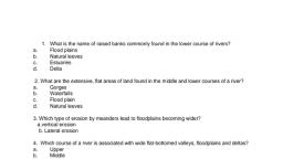
Erosional Features/, landforms of River, •, •, •, •, •, , Potholes, Waterfall, Valleys, Mesa and Butte, River Terraces
Page 71 :
Potholes
Page 72 :
• Depressions in river bed having different size, and shape, • Result of process of erosion of river bed, • Generally cylindrical or bowl shaped, • Few cm to many mts in diameter & depth, • Commonly developed in rocks having, fractures joints etc
Page 76 :
Waterfall, • A waterfall is a place where water flows over a, vertical drop or a series of steep drops in the, course of a stream or river., • It develop when a change of lithology (rock, type) takes place along the river course., • Alternate hard and soft rock layers present, • Soft rock – Max & fast erosion – Sudden drop, Rapids: Waterfall occurs in a series of steps, they, are termed as cascades or rapids
Page 79 :
Valleys, • An elongated depression between uplands,, hills, or mountains, especially one following, the course of a stream., • Types, A) V shaped valley, B) Gorge & Canyons
Page 80 :
A) V Shaped Valley, • Formed by downcutting and bank erosion by, the river, • The max rate of erosion in river is at bottom, so it results in formation of perfect V shaped, valley, • Found in youth stage, • Speed max, tools angular large = deepning of, valley
Page 83 :
Gorge & Canyons, • Gorges are very deep and narrow valleys with, very steep or vertical slope on each side, • Length varies from few mts to several km, • A canyon is a specific type of gorge where the, layers cut down by a river are essentially, stratified and horizontal in attitude, gives step, like pattern.
Page 86 :
4) Mesa & Butte, • Developed in horizontally layered rocks, • Isolated table land area with steep sided, slopes, • Top rock layer is hard and flat so give terrace, like appearance, • Large sized caps are called Mesa whereas, small sized patches are called butte
Page 89 :
5) River Terraces, • Step like flat surfaces that occurs on both the, sides of many river channels, • May formed in hard or soft rock, • It is usually covered by alluvial soil, • Mature stage, • Two types, a) Paired Terraces b) Unpaired Terraces
Page 93 :
River Transportation, • River need energy to transport material in it, • Level of energy in river changes from source to, mouth, • When energy level high – large rocks and, boulders can be transported, • Energy level low – only small particles can be, transported
Page 94 :
• Transportation of sediments in river carried, out by 4 different ways, , A), B), C), D), , Traction, Saltation, Suspension, Solution
Page 96 :
A) Traction:, Transportation of heavy material like boulders,, rock masses along the base of river is, considered as traction, The movement of material here occurs in two, ways, a) Rolling : Rounded material eg: boulders, b) Sliding: Angular material eg: Rock fragments
Page 97 :
B) Saltation:, Medium sized particles such as gravels and, course sand are lifted and dropped along river,, so they bounce along the river bed in a series, of beds, C) Suspension:, Smaller particles such as silt and fine sand are, carried along without contact with the river, bed. Materials carried in suspension usually, forms the gratest part of the total river bed
Page 98 :
D) Solution:, Dissolved material containing minerals like, calcium and sodium are carried in the water., They can not be seen by a naked eye. After, evaporation of water they settle down on river, bottom.
Page 99 :
River Depositional Process, • Where the capacity of river water drops,, deposition of river material takes place. Following, factors affects the deposition process, - Reduction in slope, - Reduction in velocity of river water, - Decrease in volume of water, - Change in river course, These conditions are favorable for river, deposition. Such deposits are called fluvial, deposits.
Page 100 :
River Depositional Features, 1) Alluvial Fans:
Page 102 :
• Alluvial fans are always formed at the base of, foothills where there is sudden drop in the, channel slope., • Alluvial fans have gentle slope than alluvial, cones, • Alluvial fans have avg slope less than 10, • Alluvial cones have avg slope 150, • Alluvial cones are made up of coarse material, than alluvial fans, • Such formations are varies in width and, thickness from few mts to few km
Page 103 :
2) River Meandering
Page 106 :
• When a stream flows along a curved, zigzag path, acquiring a loop shaped course, it is said to, meander., • Mature and old stage, • Both erosional & depositional feature, • Shape usually semicircular, sometimes circular, • Each loop of a meander belt has two types of, slopes, 1) Concave Slope: Max erosion due to water, action, vertical cliffs are developed, 2) Convex Slope: Gentle slope, deposition of sand, and gravels, sometimes soil also deposited.
Page 107 :
3) Ox-bow Lake
Page 109 :
• As the outer banks of a meander continue to be, eroded through process such as hydrualic action, the neck of a meander becomes narrow and, narrower., • Due to this the two outer bends meet and the, river cuts through the neck of the meander., • The water now takes its shortest way rather than, flowing around the bend., • Deposition gradually seals off the old meander, bend forming new straight channel., • Due to deposition, the old meander bend is left, isolated from the main channel as an ox- bow, lake.
Page 110 :
4) Natural Levees & Flood Plain, Deposits
Page 111 :
• The narrow belt of ridges of low height parallel to, the channel, build by deposition of sediments by, the flood is called natural levees., • Natural levees limit the lateral spread of river, water except during the flood., • These are helpful to control the flood,, • Generally contain silt and soil material., • An area of flat land near a river that is often, flooded when the river becomes too full., • An area of low lying ground adjacent to a river, formed mainly of river sediments and subject to, flooding
Page 112 :
5) Delta
Page 113 :
• The depositional features of almost triangular, shape at the mouth of a near to sea is called, delta., • Structure of Delta:, - A typical delta is commonly made of three, layers of which only the top layer is subaerial,, that is exposed on the surface, The three sets (layers) are, a) The bottom set b) The fore set, &, c) The top set
Page 115 :
• A) The Bottom Set:, - Formed at the base of delta, - Gentle seaward slope, - Made up of fine sized particles, - Formed at the initial stage of delta formation, B) The Fore Set:, - Intermediate layer, - Very steep slope towards sea, - Made up of thick layers of sand and clay, C) The Top Set:, - Top layer of delta, - Slope is very gentle, generally horizontal, - Formed in recent time
Page 116 :
•, -, , Condition for formation of Delta:, Suitable large place near shallow sea, Long courses of river, Medium to fine size of sediments, Large amount of sediment supply, Stable condition of sea coast, Constant rate of erosion in catchment area of, river.
Page 117 :
Civil Engineering Significance of River, Erosion and Deposition