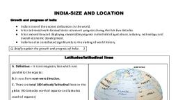
Page 1 :
oN, , , , 64, , , , " age 4, J a Shiwaliks. It js 4,, e slopes of the : kn, 16 km in width lying parallel to th belt. South of this belt, the gf, of about 8 to : in this bhabar iontkniown a, as bhabar. All the streams disappear 1 and marshy region : teraj, and rivers re-emerge and create a wet, swampy formed of older alluvium. The :, The largest part of the northern plain is terrace like feature. This, hare i he rivers and present a deposits locally ky, i, above the flood plains of t le riv : ntains calcareous dep: ly om, known as bhangar. The soil in this region co, as kankar. ing : (i) The Indian Desert, (jj), Q. 6. Write a short note on the ee T The, Central Highlands, (iii) The Island Broupso desert fies towards the western marg:, Ans. (i) The Indian Desert—The ee td covered with sand dunes, 7., of the Aravali Hills. It is an undulating sandy ae year. It has arid climate with i, region receives very low rainfall below 150 oe season. Soon after they disap, vegetation cover. Streams appear during the rainy fer thie cea sLunieisjthe oat lag, into the sand as they do not have enough water to re:, river in this region. sae, tudinal dunes becom,, , Barchans (crescent shaped dunes) cover larger areas but longitu s, , more prominent near the Indo-Pakistan boundary. ; jing to the nea, , (ii) The Central Highlands—The part of the Peninsular pat ly i ae Con, , the Narmada river covering a major area of the Malwa plateau S) A ¥e south ail, Highlands. The Vindhyan range is bounded by the Central Highlan iS = an, the Aravalis on the northwest. The further westward extension gradually me with, the sandy and rocky desert of Rajasthan. The flow of the rivers draining this region,, namely the Chambal, the Sind, the Betwa and Ken is from southw est to northeas,, thus indicating the slope. The Central Highlands are wider in the west but narrower in, the east., , (iii) The Island Groups of India—Two groups of islands are situated in India—, , (a) Lakshadweep—The Lakshadweep islands group lie close to the Malabar Coast, of Kerala. This group of islands is composed of small coral islands. Earlier they wer, known as Laccadive, Minicoy and Amindive. In 1973 these were named as Lakshadweep,, It covers small area of 32 sq. km. Kavaratti island is the administrative headquarters of, Lakshadweep. This island group has great diversity of flora and fauna. The Pitli island,, , P. group, which is uninhabited, has a bird sanctuary., , (b) Andaman and Nicobar Islands —This elongated chain of islands is located, in the Bay of Bengal extending from north to south They are bigger in size and are, more numerous and scattered. The entire group of islands is divided into two broad, categories—The Andaman in the north and the Nicobar in the south. It is believed that, these islands are an elevated portion of submarine mountains., of great strategic importance for the country. Th, in this group of islands too. These islands lie, equatorial climate and have a thick forest cover., , Map Skills, On an outline map of India show the following :, , (i) Mountain and hill ranges—the Karakoram, the Zaskar, the Patkai Bum, the, Jaintia, the Vindhya range, the Aravali and Cardamom hills. i, , (ii) Peaks—K2, Kanchenjunga, Nanga Parbat and the Anai Mudi., , (iii) Plateaus—Chhotanagpur and Malwa,, , (iv) The Indian Desert, Western, , These island groups are, ere Is great diversity of flora and fauna, close to equator and they experience, , Ghats, Lakshadweep islands,