Page 1 :
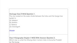
3, , DRAINAGE, , T, , he term drainage describes the river, system of an area. Look at the physical, map. You will notice that small streams, flowing from different directions come together, to form the main river, which ultimately drains, into a large water body such as a lake or a sea, or an ocean. The area drained by a single river, system is called a drainage basin. A closer, observation on a map will indicate that any, elevated area, such as a mountain or an upland,, separates two drainage basins. Such an upland, is known as a water divide (Figure 3.1)., , mA, am, treea, S, Sr, , BB, am, m, treea, S, Sr, , W, at, , er, , Di, , vi, de, , DRAINAGE SYSTEMS IN INDIA, The drainage systems of India are mainly, controlled by the broad relief features of the, subcontinent. Accordingly, the Indian rivers, are divided into two major groups:, • the Himalayan rivers; and, • the Peninsular rivers., Apart from originating from the two major, physiographic regions of India, the Himalayan, and the Peninsular rivers are different from, each other in many ways. Most of the, Himalayan rivers are perennial. It means, that they have water throughout the year., These rivers receive water from rain as well, as from melted snow from the lofty, mountains. The two major Himalayan rivers,, the Indus and the Brahmaputra originate, from the north of the mountain ranges. They, have cut through the mountains making, gorges. The Himalayan rivers have long, courses from their source to the sea., , Figure 3.1 : Water Divide, , The world’s largest drainage, basin is of the Amazon river, , • Which river has the largest basin in India?, Figure 3.2 : A Gorge, , 2021–22
Page 2 :
They perform intensive erosional activity in, their upper courses and carry huge loads of, silt and sand. In the middle and the lower, courses, these rivers form meanders, oxbow, lakes, and many other depositional features, in their floodplains. They also have welldeveloped deltas (Figure 3.3)., , The Himalayan Rivers, The major Himalayan rivers are the Indus, the, Ganga and the Brahmaputra. These rivers are, long, and are joined by many large and, important tributaries. A river alongwith its, tributaries may be called a river system., The Indus River System, The river Indus rises in Tibet, near Lake, Mansarowar. Flowing west, it enters India in the, Ladakh. It forms a picturesque gorge in this, part. Several tributaries, the Zaskar, the Nubra,, the Shyok and the Hunza, join it in the Kashmir, region. The Indus flows through Baltistan and, Gilgit and emerges from the mountains at Attock., The Satluj, the Beas, the Ravi, the Chenab and, the Jhelum join together to enter the Indus near, Mithankot in Pakistan. Beyond this, the Indus, flows southwards eventually reaching the, Arabian Sea, east of Karachi. The Indus plain, has a very gentle slope. With a total length of, 2900 km, the Indus is one of the longest rivers, of the world. A little over a third of the Indus, basin is located in India Ladakh, Jammu and, Kashmir, Himachal Pradesh and Punjab and the, rest is in Pakistan., , Source of River, Upper Course, , Middle Course, , Meander, Ox-Bow Lake, , Lower, Course, , Delta, , Figure 3.3 : Some Features Made by Rivers, , A large number of the Peninsular rivers are, seasonal, as their flow is dependent on rainfall., During the dry season, even the large rivers, have reduced flow of water in their channels., The Peninsular rivers have shorter and, shallower courses as compared to their, Himalayan counterparts. However, some of, them originate in the central highlands and flow, towards the west. Can you identify two such, large rivers? Most of the rivers of peninsular, India originate in the Western Ghats and flow, towards the Bay of Bengal., , • According to the regulations, of the Indus Water Treaty (1960), India can, use only 20 per cent of the total water carried by, the Indus river system. This water is used for, irrigation in Punjab, Haryana and the southern, and the western parts of Rajasthan., , The Ganga River System, The headwaters of the Ganga, called the, ‘Bhagirathi’ is fed by the Gangotri Glacier and, joined by the Alaknanda at Devaprayag in, Uttarakhand. At Haridwar, the Ganga emerges, from the mountains on to the plains., , 18, , CONTEMPORARY INDIA-I, , 2021–22
Page 3 :
Figure 3.4 : Major Rivers and Lakes, , DRAINAGE, , 19, , 2021–22
Page 4 :
the northernmost point of the Ganga delta. The, river bifurcates here; the Bhagirathi-Hooghly, (a distributary) flows southwards through the, deltaic plains to the Bay of Bengal. The, mainstream, flows southwards into, Bangladesh and is joined by the Brahmaputra., Further downstream, it is known as the, Meghna. This mighty river, with waters from, the Ganga and the Brahmaputra, flows into, the Bay of Bengal. The delta formed by these, rivers is known as the Sundarban Delta., Figure 3.5 : Confluence of Bhagirathi and Alaknanda at, Devaprayag, , The Ganga is joined by many tributaries, from the Himalayas, a few of them being major, rivers, such as the Yamuna, the Ghaghara, the, Gandak and the Kosi. The river Yamuna rises, from the Yamunotri Glacier in the Himalayas., It flows parallel to the Ganga and as a right, bank tributary meets the Ganga at Allahabad., The Ghaghara, the Gandak and the Kosi rise, in the Nepal Himalaya. They are the rivers,, which flood parts of the northern plains every, year, causing widespread damage to life and, property, whereas, they enrich the soil for, agricultural use., The main tributaries, which come from the, peninsular uplands, are the Chambal, the, Betwa and the Son. These rise from semi-arid, areas, have shorter courses and do not carry, much water in them. Find out where and how, they ultimately join the Ganga., , • The Namami Gange Programme, is an Integrated Conservation Mission approved as, a ‘flagship programme’ by the Union Government, in June 2014 to accomplish the twin objectives of, effective abatement of pollution, conservation and, rejuvenation of the national river, Ganga. You may, explore about this project at http://nmcg.nic.in/, NamamiGanga.sspx#, , • The Sundarban Delta derived, its name from the Sundari tree, which grows well, in marshland., • It is the world’s largest and fastest growing delta., It is also the home of Royal Bengal tiger., , The length of the Ganga is over 2500 km., Look at Figure 3.4; can you identify the type of, drainage pattern formed by the Ganga river, system? Ambala is located on the water divide, between the Indus and the Ganga river systems., The plains from Ambala to the Sunderban, stretch over nearly 1800 km, but the fall in its, slope is hardly 300 metres. In other words, there, is a fall of just one metre for every 6 km., Therefore, the river develops large meanders., The Brahmaputra River System, The Brahmaputra rises in Tibet east of, Mansarowar lake very close to the sources of, the Indus and the Satluj. It is slightly longer, than the Indus, and most of its course lies, outside India. It flows eastwards parallel to, the Himalayas. On reaching the Namcha, Barwa (7757 m), it takes a ‘U’ turn and enters, India in Arunachal Pradesh through a gorge., Here, it is called the Dihang and it is joined by, the Dibang, the Lohit, and many other, tributaries to form the Brahmaputra in Assam., , Enlarged with the waters from its right and, left bank tributaries, the Ganga flows, eastwards till Farakka in West Bengal. This is, , 20, , • Brahmaputra is known as, the Tsang Po in Tibet and Jamuna in Bangladesh., , CONTEMPORARY INDIA-I, , 2021–22
Page 5 :
In Tibet, the river carries a smaller volume of, water and less silt as it is a cold and a dry area., In India, it passes through a region of high, rainfall. Here the river carries a large volume of, water and considerable amount of silt. The, Brahmaputra has a braided channel in its entire, length in Assam and forms many riverine islands., Do you remember the name of the world’s largest, riverine island formed by the Brahmaputra?, Every year during the rainy season, the, river overflows its banks, causing widespread, devastation due to floods in Assam and, Bangladesh. Unlike other north Indian rivers,, the Brahmaputra is marked by huge deposits, of silt on its bed causing the riverbed to rise., The river also shifts its channel frequently., The Peninsular Rivers, The main water divide in Peninsular India is, formed by the Western Ghats, which runs from, north to south close to the western coast. Most, of the major rivers of the Peninsula, such as, the Mahanadi, the Godavari, the Krishna and, the Kaveri flow eastwards and drain into the, Bay of Bengal. These rivers make deltas at, their mouths. There are numerous small, streams flowing west of the Western Ghats., The Narmada and the Tapi are the only long, rivers, which flow west and make esturies. The, drainage basins of the peninsular rivers are, comparatively smaller in size., The Narmada Basin, The Narmada rises in the Amarkantak hills, in Madhya Pradesh. It flows towards the west, in a rift valley formed due to faulting. On its, way to the sea, the Narmada creates many, picturesque locations. The ‘Marble rocks’,, near Jabalpur, where the Narmada flows, through a deep gorge, and the ‘Dhuadhar, falls, where the river plunges over steep rocks,, are some of the notable ones., , • The Narmada river, conservation mission has been undertaken by the, government of Madhya Pradesh by a scheme named, Namami Devi Narmade. You may visit their website., http://www.namamidevinarmade.mp.gov.in to, learn more about it., , All tributaries of the Narmada are very short, and most of these join the main stream at right, angles. The Narmada basin covers parts of, Madhya Pradesh and Gujarat., The Tapi Basin, The Tapi rises in the Satpura ranges, in the, Betul district of Madhya Pradesh. It also flows, in a rift valley parallel to the Narmada but it is, much shorter in length. Its basin covers parts, of Madhya Pradesh, Gujarat and Maharashtra., The coastal plains between Western Ghats, and the Arabian Sea are very narrow. Hence,, the coastal rivers are short. The main west, flowing rivers are Sabarmati, Mahi,, Bharathpuzha and Periyar. Find out the states, in which these rivers drain the water., The Godavari Basin, The Godavari is the largest Peninsular river. It, rises from the slopes of the Western Ghats in, the Nasik district of Maharashtra. Its length is, about 1500 km. It drains into the Bay of Bengal., Its drainage basin is also the largest among the, peninsular rivers. The basin covers parts of, Maharashtra (about 50 per cent of the basin, area lies in Maharashtra), Madhya Pradesh,, Odisha and Andhra Pradesh. The Godavari is, joined by a number of tributaries, such as the, Purna, the Wardha, the Pranhita, the Manjra,, the Wainganga and the Penganga. The last three, tributaries are very large. Because of its length, and the area it covers, it is also known as the, Dakshin Ganga., The Mahanadi Basin, The Mahanadi rises in the highlands of, Chhattisgarh. It flows through Odisha to reach, , DRAINAGE, , 21, , 2021–22
Page 6 :
the Bay of Bengal. The length of the river is, about 860 km. Its drainage basin is shared by, Maharashtra, Chhattisgarh, Jharkhand,, and Odisha., The Krishna Basin, Rising from a spring near Mahabaleshwar, the, Krishna flows for about 1400 km and reaches, the Bay of Bengal. The Tungabhadra, the, Koyana, the Ghatprabha, the Musi and the, Bhima are some of its tributaries. Its drainage, basin is shared by Maharasthra, Karnataka, and Andhra Pradesh., The Kaveri Basin, The Kaveri rises in the Brahmagri range of the, Western Ghats and it reaches the Bay of Bengal, in south of Cuddalore in Tamil Nadu. The total, length of the river is about 760 km. Its main, tributaries are Amravati, Bhavani, Hemavati, and Kabini. Its basin drains parts of Karnataka,, Kerala and Tamil Nadu., • The river Kaveri makes the, second biggest waterfall in India, known as, Shivasamudram Falls. The hydroelectric power, generated from the falls is supplied to Mysuru,, Bengaluru and the Kolar Gold Field., •, , The name of the biggest waterfall, , in India., , Besides these major rivers, there are some, smaller rivers flowing towards the east. The, Damoder, the Brahmani, the Baitarni and the, Subarnrekha are some notable examples., Locate them in your atlas., • 71 per cent of the world’s, surface is covered with water, but 97 per cent of, that is salt water., • Of the 3 per cent that is available as freshwater,, three quarters of it is trapped as ice., , Imagine that if Srinagar, Nainital and other, tourists places did not have a lake would they, have been as attractive as they are today? Have, you ever tried to know the importance of lakes, in making a place attractive to tourists? Apart, from attraction for tourists, lakes are also useful, to human beings in many ways., • Lakes of large extent are called seas,, like the Caspian, the Dead and the Aral seas., , India has many lakes. These differ from, each other in size and other characteristics., Most lakes are permanent; some contain water, only during the rainy season, like the lakes in, the basins of inland drainage of semi-arid, regions. There are some lakes which are the, result of the action of glaciers and ice sheets,, while others have been formed by wind, river, action and human activities., A meandering river across a floodplain, forms cut-offs that later develops into ox-bow, lakes. Spits and bars form lagoons in the, coastal areas, e.g. the Chilika lake, the Pulicat, lake and the Kolleru lake. Lakes in the region, of inland drainage are sometimes seasonal; for, example, the Sambhar lake in Rajasthan, which, is a salt water lake. Its water is used for, producing salt., Most of the freshwater lakes are in the, Himalayan region. They are of glacial origin., In other words, they formed when glaciers, dug out a basin, which was later filled with, snowmelt. The Wular lake in Jammu and, Kashmir, in contrast, is the result of tectonic, activity. It is the largest freshwater lake in, India. The Dal lake, Bhimtal, Nainital, Loktak, and Barapani are some other important, freshwater lakes., , LAKES, You may be familiar with the valley of Kashmir, and the famous Dal Lake, the house boats and, shikaras, which attract thousands of tourists, every year. Similarly, you may have visited, some other tourist spot near a lake and enjoyed, boating, swimming and other water games., 22, , Figure 3.6 : Loktak Lake, , CONTEMPORARY INDIA-I, , 2021–22
Page 7 :
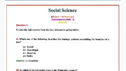
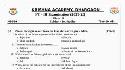
Apart from natural lakes, the damming of, the rivers for the generation of hydel power has, also led to the formation of lakes, such as Guru, Gobind Sagar (Bhakra Nangal Project)., , National River Conservation Plan, (NRCP), , The river cleaning programme in the, country was initiated with the launching, of the Ganga Action Plan (GAP), in 1985. The Ganga Action Plan was, expanded to cover other rivers under the, National River Conservation Plan, (NRCP) in the year 1995. The objective, of the NRCP is to improve the water, quality of the rivers, which are major, water sources in the country, through, the implementation of pollultion, abatement work., Source: http://nrcd.nic.in/nrcp.pd as on, 25.07.17, , Activity, Make a list of natural and artificial, lakes with the help of the atlas., , Lakes are of great value to human beings., A lake helps to regulate the flow of a river., During heavy rains, it prevents flooding and, during the dry season, it helps to maintain, an even flow of water. Lakes can also be used, for developing hydel power. They moderate the, climate of the surroundings; maintain the, aquatic ecosystem, enhance natural beauty,, help develop tourism and provide recreation., , ROLE OF RIVERS IN THE ECONOMY, Rivers have been of fundamental importance, throughout the human history. Water from, rivers is a basic natural resource, essential, for various human activities. Therefore,, riverbanks have attracted settlers from ancient, times. These settlements have now become big, cities. Make a list of cities in your state which, are located on the bank of a river., Using rivers for irrigation, navigation,, hydro-power generation is of special, significance — particularly to a country like, India, where agriculture is the major source, of livelihood of the majority of its population., , RIVER POLLUTION, The growing domestic, municipal, industrial, and agricultural demand for water from rivers, naturally affects the quality of water. As a, , result, more and more water is being drained, out of the rivers reducing their volume. On the, other hand, a heavy load of untreated sewage, and industrial effluents are emptied into the, rivers. This affects not only the quality of water, but also the self-cleansing capacity of the river., For example, given the adequate streamflow,, the Ganga water is able to dilute and assimilate, pollution loads within 20 km of large cities., But the increasing urbanisation and, industrialisation do not allow it to happen and, the pollution level of many rivers has been, rising. Concern over rising pollution in our, rivers led to the launching of various action, plans to clean the rivers. Have you heard about, such action plans? How does our health get, affected by polluted river water? Think about, “life of human beings without fresh water”., Arrange a debate on this topic in the class., , EXERCISE, 1. Choose the right answer from the four alternatives given below., (i) In which of the following states is the Wular lake located?, (a) Rajasthan, (c) Punjab, (b) Uttar Pradesh, (d) Jammu and Kashmir, , DRAINAGE, , 23, , 2021–22
Page 8 :
(ii) The river Narmada has its source at, (a) Satpura, , (c) Amarkantak, , (b) Brahmagiri, , (d) Slopes of the Western Ghats, , (iii) Which one of the following lakes is a salt water lake?, (a) Sambhar, , (c) Wular, , (b) Dal, , (d) Gobind Sagar, , (iv) Which one of the following is the longest river of the Peninsular India?, (a) Narmada, , (c) Godavari, , (b) Krishna, , (d) Mahanadi, , (v) Which one amongst the following rivers flows through a rift valley?, (a) Mahanadi, , (c) Krishna, , (b) Tungabhadra, , (d) Tapi, , 2. Answer the following questions briefly., (i) What is meant by a water divide? Give an example., (ii) Which is the largest river basin in India?, (iii) Where do the rivers Indus and Ganga have their origin?, (iv) Name the two headstreams of the Ganga. Where do they meet to form the Ganga?, (v) Why does the Brahmaputra in its Tibetan part have less silt, despite a, longer course?, (vi) Which two Peninsular rivers flow through trough?, (vii) State some economic benefits of rivers and lakes., 3. Below are given names of a few lakes of India. Group them under two categories, – natural and created by human beings., (a), , Wular, , (b), , Dal, , (c), , Nainital, , (d), , Bhimtal, , (e), , Gobind Sagar, , (g), (i), (k), (m), , (f), , Loktak, , Barapani, , (h), , Chilika, , Sambhar, , (j), , Rana Pratap Sagar, , Nizam Sagar, , (l), , Pulicat, , Nagarjuna Sagar, , (n), , Hirakund, , 4. Discuss the significant difference between the Himalayan and the Peninsular, rivers., 5. Compare the east flowing and the west flowing rivers of the Peninsular plateau., 6. Why are rivers important for the country’s economy?, Map Skills, (i), , On an outline map of India mark and label the following rivers: Ganga,, Satluj, Damodar, Krishna, Narmada, Tapi, Mahanadi, and Brahmaputra., , (ii), , On an outline map of India mark and label the following lakes: Chilika,, Sambhar, Wular, Pulicat, Kolleru., , 24, , CONTEMPORARY INDIA-I, , 2021–22
Page 9 :
Project/Activity, Solve this crossword puzzle with the help of given clues., Across, 1., 2., 3., 4., 5., 6., 7., 8., , Nagarjuna Sagar is a river valley project. Name the river?, The longest river of India., The river which originates from a place known as Beas Kund., The river which rises in the Betul district of MP and flows westwards., The river which was known as the “Sorrow” of West Bengal., The river on which the reservoir for Indira Gandhi Canal has been built., The river whose source lies near Rohtang Pass., The longest river of Peninsular India?, , Down, 9., 10., 11., 12., 13., 14., 15., , A tributary of Indus originating from Himachal Pradesh., The river flowing through fault, drains into the Arabian Sea., A river of south India, which receives rainwater both in summer and winter., A river which flows through Ladakh, Gilgit and Pakistan., An important river of the Indian desert., The river which joins Chenab in Pakistan., A river which rises at Yamunotri glacier., , DRAINAGE, , 25, , 2021–22