Notes of 9 C,D,E,F,G, Social Science & Social Science A+ BLOG-CLASS-9-SOCIAL SCIENCE II-CHAPTER-2-THE SIGNATURE OF TIME-QUESTION &ANSWERS.pdf - Study Material
Page 1 :
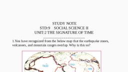
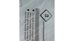
A+ SOCIAL SCIENCE II STD - IX, Chapter – 2, THE SIGNATURE OF TIME, 1. You have recognized from the below map that the earthquake zones, volcanoes, and mountain ranges, overlap. Why is this so?, , , , , , The Earth surface is composed of many individual plates (lithospheric plates) that move and interact,, constantly changing and reshaping Earth's outer layer., Earthquake zones, volcanoes and distribution of mountains occur because of movement of, lithospheric plates at the plate boundaries., That is why the earthquake zones, volcanoes, and mountain ranges overlap, , 2. What is lithosphere?, The outermost layer of the earth, the crust, together with the upper part of the mantle is known as the, lithosphere, 3. What is the average thickness of the lithosphere?, 100 KM, 4. Define lithospheric plates, The portions of the lithosphere which are several thousand kilometres wide and roughly 100, kilometres thick are called lithospheric plates, 5. What is asthenosphere?, The part beneath the lithosphere, where the materials exist in a partially molten state is known as, asthenosphere., 6. Define Magma, Magma is a part of the mantle which remain molten due to the high temperature at the earth’s interior, and undergoes continuous convection. This causes the movement of lithospheric plates., 7. Who put forward the idea of continental drift?, Alfred Wegener, 8. Write an example for the Fold mountain range. How it is formed?, , A+ BLOG- www.apluseducare.blogspot.com Whatsapp 9746544422, , Page 1
Page 2 :
A+ SOCIAL SCIENCE II STD - IX, , , The Himalaya. It is formed along the convergent margins between the Indian plate and the Eurasian, plate., 9. Make a flow chart about the different lithospheric plates, Lithospheric plates, , Major Plates, , Minor Plates, , Pacific, Eurasian, African, North America, South America, Antarctic, Indo-Australian, , Philippine, Cocos, Nasca, Caribbean, Scotia, Arabian, , 10. Prepare a flow chart about plate margins and created landforms, , 11. Which is the largest lithospheric plate?, The Pacific plate, 12. Name the lithospheric plate which involves oceanic parts alone., The Pacific plate, 13. What are called subduction zones?, If there is any difference in density between the plates along a convergent margin, the denser plate, will submerge under the lighter one. These zones are called subduction zones., , A+ BLOG- www.apluseducare.blogspot.com Whatsapp 9746544422, , Page 2
Page 3 :
A+ SOCIAL SCIENCE II STD - IX, 14. Identify the plate margins where the world's major fold mountains are formed?, Fold mountains, , Plates, , The Himalayas, , The Indian plate and the Eurasian plate., , The Alps, , The Eurasian plate and the African plate, , The Andes, , The South American and the Nasca plate, , The Atlas, , The Eurasian plate and the African plate, , 15. Write an example for the Ocean trenches that are developed in subduction zones. Identify the plates, responsible for this, The Challenger Deep in the Pacific Ocean, Philippine plates are responsible for Challenger deep in Pacific Ocean where the Pacific plate is, subducting beneath the Philippine plate., 16. How Mid-Atlantic Ridge formed?, The Mid-Atlantic Ridge has been formed as a result of the divergence of the plate margin between, the African plate and the South American plate., 17. What are Mid Oceanic ridges?, Magma comes out through the gap formed due to the divergence of plates and solidifies to form, mountains. These types of mountains are known as Mid Oceanic ridges., 18. How fault zones are formed? Write an example, Landforms are not generally created along the margins where the plates slide past each other. But, such margins are fault zones., The San Andreas Fault Zone in North America, 19. The plate margins are generally vulnerable to earthquakes, volcanoes, and faults. Why?, Because the plate margins are weaker than other areas, 20. Make a flow chart related to Earth Movements, , 21. What is an earthquake? /How do earthquakes occur?, Rocks in the deeper part of the earth undergo displacement and faults due to plate movements and, other causes., A+ BLOG- www.apluseducare.blogspot.com Whatsapp 9746544422, , Page 3
Page 4 :
A+ SOCIAL SCIENCE II STD - IX, , , , , , Under such situations, severe pressure is exerted on the earth's lithosphere., Seismic waves are generated, These waves create tremors on the earth's surface., These tremors are experienced by us as earthquake., , 22. What is the difference between uplift and subsidence?, As a result of the earth movements, some regions on the earth's crust are either raised or lowered., Raising of the crustal portions are called uplift and lowering of the crust are called subsidence., 23. What are the reasons for the occurrence of earthquakes?, Plate movements, Faulting, Collapse of the roofs of mines, Pressure in reservoirs, Volcanic eruptions, 24. Define Focus and Epicentre of an earthquake, The deep points inside the earth where the earthquake occurs are known as focus., The point vertically above it on the earth's surface is known as epicentre., 25. Which are the different types of seismic waves?, Primary waves, secondary waves and surface waves., 26. Which one of the seismic waves cause maximum destruction on the earth's surface?, The surface waves, 27. Which is the scale used to measure the intensity of earthquakes?, The Richter scale, 28. Which is the instrument used for recording seismic waves?, Seismograph, 29. What are tsunamis?, Tremor waves originating due to earthquakes, volcanic eruptions, meteor impact. etc. in the ocean, floor generates huge sea waves rising to several metres. Such waves are called Tsunamis, 30. What is the term meaning of Japanese word ‘Tsunami’?, Harbour waves, 31. Write the impact of Tsunami., The coastal regions mainly affected by the disastrous effects of Tsunamis., The visible impact of Tsunami is the damage and destruction to life and property caused by it, 32. Kerala coast was also affected by Tsunami on 26 December 2004.What was the reason for that?, It was caused by the intense earthquake waves originated from Sumatra in Indian Ocean, 33. What are the use of Tsunami surveillance and warning systems?, Aims to identify the areas prone to Tsunami, To extend warning to the coastal areas so as to prevent loss of life., , A+ BLOG- www.apluseducare.blogspot.com Whatsapp 9746544422, , Page 4
Page 5 :
A+ SOCIAL SCIENCE II STD - IX, 34. Name the real time Tsunami monitoring system introduced by NOAA., Dart (Deep ocean Assessment and Reporting of Tsunami), 35. Write the full form of NOAA, National Oceanic and Atmospheric Administration, 36. What are the measures we can take to mitigate the impact of Tsunamis?, Recession in sea level may be an indicator of Tsunami. If so, move on to safer locations., Take official warnings seriously., Don’t arrive at self conclusion that the dangerous situation is over, wait for official declaration., Once trapped by Tsunami waves try to escape holding any floating materials firmly., 37. How volcanoes are formed?, Volcanoes are formed by molten rock material coming out through the fissures along the plate, margins., 38. What do you mean by 'the Pacific Ring of Fire?, Nearly 80% of the world's volcanoes are situated around the Pacific Ocean. This zone containing, more than 452 volcanoes is known as 'the Pacific Ring of Fire'., 39. How are volcanoes useful to mankind?, The soil formed by the weathering of lava rocks is fertile., Example: the black soil of the Deccan plateau., Volcanic ash is a good manure., Geysers are formed in many volcanic regions. Such regions are being developed as tourist centres., Example: The Old Faithful Geyser, Yellow Stone National Park – North America., 40. Is there any chance of Volcanic eruptions in Kerala?, Located at the extreme southern tip of the Indian subcontinent, Kerala lies near the center of the, Indian Plate; the state is subject to comparatively little seismic or volcanic activity., , Prepared by, PRIYA B, HST(SS), CSHSS, THRISSUR, More Resources, Visit https://apluseducare.blogspot.com/, Telegram Group: https://t.me/joinchat/ELv60hbE_g9Hvimlp0s1BA, , A+ BLOG- www.apluseducare.blogspot.com Whatsapp 9746544422, , Page 5
 Learn better on this topic