Page 1 :
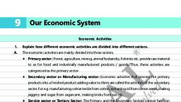
2nd Proof, , Standard, , 12, , : 6 | Social Science, , Understanding the Map, Introduction, , 1., , Tourists can receive information of the tourist destinations by reading different maps. ( or )( ), , 2., , GPS means _______________ ., , (A), , (A) Globe Positioning System, , (B) Globe Private System, , (C) Globe Private System, , (D) Good Privacy Service, , 3., , The globe of the earth is useful to study the whole earth. ( or ), , ( ), , 4., , What will be more helpful to study about Patan city of Gujarat ?, , (B), , (A) Globe, , (B) Map, , (C) Pictures, , 5., , Why are maps more useful than a globe?, , A., , Because of the following reasons maps are more useful than a globe:, , (D) All of them, , Maps can show more details., Many maps when put together make an atlas and show various continents, countries and can, , provide information about any particular aspect., Maps can be drawn in small scale as well as in large scale., Maps can be folded / rolled and are easily portable., , 6., , Mappa Mundi is a word of the Latin language.***, , 7., , The word map is derived from the Latin word Mappa Mundi., , 8., , What is the meaning of ‘Mappa Mundi’ ?, , A., , The meaning of ‘Muppa Mundi‘ is the piece of cloth that can be held in the hand., , 9., , What is a map ?, , A., , A drawing of the earth’s surface or any one part of it on the plain flat paper is known as a map., Atlas Map, , 10., A., 11., A., , What is an Atlas ?, An atlas is a collection of maps showing various details of earth or its one part., What details does an atlas contain ?, An atlas contains political, administrative, natural and cultural details., , 12., , Map shows physical details like mountains, plateaus, plains, rivers, lakes, etc., , 13., , Transportation and industries are the cultural details that can be shown in a map. ( or ) ( ), , 14., , Transportation, industries, farming and irrigation are shown in the cultural map. ***, , 15., , Oceans are shown in the cultural map. ( or )***, I am ‘Confident’... I am a Change Maker., , ( ), 45
Page 2 :
2nd Proof, , Chapter 12 : Understanding the Map, Types Of Map, 16., A., 17., A., , How many types of maps are there ?, There are two types of maps : (1) Thematic map and (2) Scale Based map., Write the types of Thematic maps.***, Thematic maps are categorized into two main sections based on the natural and cultural details, depicted in them – Natural maps and Cultural maps., , 18., A., , What are scale based maps?, Map that shows physical details is called scale based map. It shows natural landforms like mountains,, plateaus, plains, rivers, oceans etc. This type of map also shows details of wild animals, vegetation,, forests, minerals etc., , 19., , Mountains, plateaus are shown in ______________ map., (A) Political, , (B) Climate, , (C) Topographic, , 20., , Wild animals and vegetation are part of the physical maps. ( or ), , 21., , What details are shown in the topographic map ?, , A., 22., , 24., A., , (D) Historical, ( ), , Landscapes like mountains, plateaus plains, waterways etc. are shown in topographic maps., Which of the following details is shown in the climate map ?, (A) Rainfall, , 23., , (C), , (B) Wind, , (C) Temperature, , Which map is used to show the information about celestial bodies ?, (A) Topographic map, , (B) Industrial map, , (C) Astronomical map, , (D) Cultural map, , (D), (D) All of them, (C), , Write a short note on a scale based map., Map that shows physical details is called a scale based map. A scale based map displays natural, landforms like mountains, plateaus, plains, rivers, oceans etc. Maps showing the details of wild, animals, vegetation, forests, minerals etc. are part of scale-based maps. It can be of three types., (1) Topographic Map : Landscapes like mountains, plateaus, plains, water ways, etc. are shown, in this type of map., (2) Climate map : This type of map focuses on the details of climate, temperature, rainfall, winds,, etc., (3) Astronomical Map : Information about celestial bodies like planets, satellites, galaxies, stars, (constellations) etc. are shown in this type of map., , 25., A., , What is meant by cultural maps ?, The map which outlines the man made details is called a cultural map. This map outlines various, human activities. The map of the state, farming, population, transportation are the examples of, cultural maps., , 46, , I am ‘Confident’... I am a Change Maker.
Page 3 :
2nd Proof, , Standard, 26., , Cultural map outlines various human activities. ( or ), , 27., , Man made details are shown in cultural maps., , 28., , In which map details of farming, population, transportation, etc. are shown ?, , 29., A., , : 6 | Social Science, ( ), , (A) Topographic map, , (B) Physical map, , (C) Climate map, , (D) Cultural map, , (D), , Which map is called a political map ?, A map which shows the details of a continent, country, local administration and their frontier is, called a political map., , 30., , Industrial map shows the details of the industrial sector and production. ( or ), , 31., , Which details are shown in an industrial map?, , A., 32., A., 33., A., , ( ), , Industrial map shows the details of the industrial sector, phased history of industries, production, etc., What is a historical map?, A map which shows the history of regional and national administration is called a historical map., Differentiate between scale-based maps and cultural maps.***, A map that shows physical details is called a natural map. It shows natural landforms like mountains,, plateaus, plains, rivers, oceans, etc. It also shows wild animals, vegetation, forests, minerals etc., When the map outlines the man-made details it is called a cultural map. This map outlines various, human activities. The map of the state, farming, population, transportation are the examples of, cultural maps., , 34., , Match the following :, A, , B, , Answer, , (1) Astronomical map, , (A) mountain, plateaus, , (1) - B, , (2) Political map, , (B) planets, satellites, , (2) - D, , (3) Topographic map, , (C) industrial sector, , (3) - A, , (4) Industrial map, , (D) continent, country, , (4) - C, , Types Of Maps On The Basis Of Scale, 35., , 36., , Generally, if the scale of a map is _______________ then that map is called a large scale map. ( A ), (A) less than 1 cm : 50 km, , (B) more than 1 cm : 50 km, , (C) less than 1 cm : 10 km, , (D) more than 1 cm :100 km, , Map of which of the following is an example of a large-scale map., (A) Village, , 37., A., , (B) District, , (C) City, , (D), (D) All of them, , What is a large scale map ?, Generally if the scale of the map is less than 1 cm : 50 km then that map is called a large-scale map., I am ‘Confident’... I am a Change Maker., , 47