Page 1 :
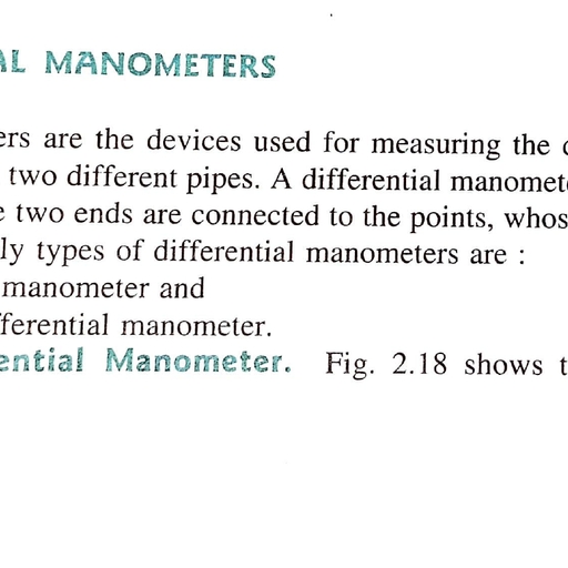
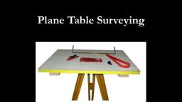
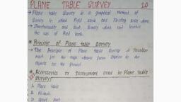
Plane Table Surveying, , 131, , Procedure, , (a) Suppose A and B are two stations. The plane table is set up over A. The, , table is levelled by spirit level and centred by U-fork so that the point a is, i1st over station A. The north line is marked on the right-hand top corner, , of the sheet by trough compass., (b) With the alidade is touching a, the rangng rod at B is bisected and a ray, , is drawn. The distance AB is measured and plotted to any suitable scale., So, the point b represents station B., (c)The table is shifted and set up over B. It is levelled and centred so that b, is just over B. Now the alidade is placed along the line ba, and the ranging, rod at A is bisected by turning the table clockwise or anticlockwise., At this time the centring may be disturbed, and should be adjusted, , immediately if required. When the centring, levelling and bisection of, the ranging rod at A are perfect then the orientation is said to be perfect, , (Fig. 4.9)., , Alidade, O, , b, , a, , Alidade, , O, b, , S Sight Vane, O= Object Vane, B, , Fig. 4.9, , 4.4, , Orientation by Backsighting, , PROCEDURE OF SETTING UP A PLANE, , TABLE OVER A STATION, The following steps have to be performed in order to set up a plane table over, , a station:, , ., , Fixing, , the Table, p, o d stand is placed, tne table is, fixed on it by, , on, , Tripod Stand, , the required station with its, wing nut at the bottom., , over, , a, , the, , legs well apart., , Then
Page 2 :
Surveying und Levelling, , 132, , 2. Levelling the Table, The table, , is, , levelled, , by placing, , the spirit level, , bubble, , is, , brought, , positions on the table. The, the legs., positions of the table by adjusting, , at diflerent, , to, , corners, , the centre of, , its, , an, and varou, run, , run, , al, , CVCr, , 3. Centring the Table, The drawing sheet is fixed on the table. A suitable point P 1s selected on the, , neet, , to represent the station P on the ground. A pin 1s then fixed on this selected point, , The upper pointed end of the U-fork is made in contact with the station pin and, the plumb bob which is suspended from the hook at the lower end is brouoh:, , just over the station P by turning the table clockwise or anticlockwise or slighl, adjusting the legs. This operation is called centring. The table is then clamped, , Care should be taken not to disturb the levelling., , 4. Marking the North Line, The trough compass is placed on the right-hand top corner with its north end, approximately towards the north. Then the compass is turned clockwise or, , anticlockwise so that the needle coincides exactly with the 0-0 mark. Now a line, representingthe north line is drawn through the edge of the compass. It should, be ensured that the table is not turned., , 5. Orientation, When, , plane table, , survey is to be conducted by connecting several stations, the, orientation must be performed at every successive station. It, may be done by, a, magnetic needle or by the backsighting method. The backsighting process is, always preferred, because it is reliable. During orientation, it should, always be, remembered that the requirements of centring,, levelling, and orientation must be, , satisfied simultaneously., , 4.5, The, , METHODS OF PLANE TABLING, following, , are, , the four, , methods of plane tabling:, , 1. Radiation,, , 2. Intersection,, 3. Traversing, and, 4. Resection., , 1. Radiation, This method is, suitable for, the objects from a, method, rays are drawn from locating, single station. In this, the, station to the, the station to the, objects, and the distances firom, objects are measured and, to any suitable, plotted, respective rays., scale along the
Page 3 :
Plane Table Surveying, 133, Procedure, , P is a, (a) DSuppose, are visible., , The, , ), , the, , plane, , station, , table, , the, , ground from where the objects A, B,, , Set up over the, , 1S, , table, which, , on, , station P. A, , is then levelled and, , sheet to represent the station P., , (cThe north line, , is marked, , on, , the, , ), , sheet is fixed, , on, , on, , the, , centred. A point p is selected, , right-hand top, , trough compass circular box compass., With the alidade touching p, the ranging rods at, or, , drawing, , and the rays drawn., , corner, , C and, , of the sheet, , A, B, C and D, , are, , with, , bisected, , (e) The distances PA, PB, PC, and PD are measured and, plotted to any suitable, scale to obtain the points a, b, c, and d,, representing the objects A, B, C, and D (Fig, 4.10), on paper., B, , P, , D, , Fig. 4.10, , Plain Tabling by Radiation, , 2. The, , Intersection Method, This method is suitable for locating inaccessible, points by, rays drawn from two instrument stations., , the intersection of the, , Procedure, a) Suppose A and B are two stations and P is an object on the far bank of, a river. Now it is required to fix the position of P on the sheet by the, , intersection of rays, drawn from A and B., (6) The table is set up at A. It is levelled and centred so that a point a on the, sheet is just over the station A. The north line is marked on the, right-hand, top corner. The table is then clamped., , (C)With the alidade touching a, the object P and the ranging rod at B are, bisected, and rays are drawn through the fiducial edge of the alidade., , a) The distance AB is measured and plotted to any suitable seale to obtain, , the point b., e, , The table is shifted and centred over B and levelled properly. Now the, , alidade is placed along the line ba and orientation is done by backsighting., and, At this time, it should be remembered that the centring, leveling, orientation must be perfect simultaneously.
Page 4 :
Surveying and Levelling, , 134, , (With the alidade is touching b, the object P is bisected and, is a, and aa rav, is, ray, drawn,., Suppose this ray intersects the previous ray at a point p. This point., p is, , the required plotted position of P (Fig. 4.11)., P, , River, , a, , A, , B, , Fig. 4.11, , Plain Tabling by Intersection, , 3. The Traversing Method, This method is suitable for connecting the traverse stations. This is similar to, compass traversing or theodolite traversing. But here, fielding and plotting are done, , simultaneously with the help of the radiation and intersection methods., , Procedure, (a) Suppose A, B, C and D are the traverse stations., (b) The table is set up at the station A. A suitable pointa is selected on the, sheet in such a way that the whole area, may be plotted in the sheet. The, table is centred, levelled and clamped. The north line is marked on the, , right-hand top corner of the sheet., (c) With the alidade touching the point a, the ranging rod at B is bisected and., a ray is drawn. The distance AB, is measured and plotted to any suitable, Scale., , (d), , The table is shifted and centred, , over, , back-sighting and clamped., (e) With the alidade touching the point b,, and, a, , scale., , B. It is then, , levelled, oriented by, , the ranging rod at C is bisected, ray is drawn. The distance BC is measured and, plotted to the same, , () The table is shifted and set up at C and the same, procedure, gIn this manner, all stations of the traverse are connected., , is, , repeated.
Page 5 :
Plane Table Surveying, , (, , 135, , At the end, the finishing point may not coincide with the starting point, and there may be some closing error. This error is adjusted graphically, , by Bowditch's rule given in Sec. 3.13)., )After making the corrections for closing error, the table is again set up, , at 4. After centring, levelling and orientation, the surrounding details are, located by radiation., , ), , The table is then shifted and set up at all the stations of the traverse, , and after proper adjustments the details are located by the radiation and, intersection methods (Fig. 4.12)., , d, , C, , c, , b, , b, , A, , B, Fig. 4.12, , Plain Tabling by Traversing, , 4. The Resection Method, This method is suitable for, establishing, , new, , stations, , at a, , missing details., , place, , in order to locate, , Procedure, (a) Suppose it is required to establish a station at the position P. Let us select, two, , points A and B on the ground., , The distance AB is measured and plotted, any suitable scale. This line AB is known as the base line., (6) The table is set up at 4. It is levelled, centred and oriented by bisecting, to, , the, , ranging, , rod at B. The table. is then, , clamped., , (C)With the alidade touching point a, the ranging rod at P is bisected and a, 1s drawn. Then a point Pi is marked on this, ray by estimating with, Tray, the eye., a) The table is shifted and centred in such a way that P, , is just over P. It is, , then oriented by backsighting the, ranging rod at A., eWith the alidade touching the point b. the ranging rod at B is bisected and, , a ray is drawn. Suppose this ray intersects the previous ray at a pont, s, , point represents the position of the station P, , on the sheet. 1hen the
Page 6 :
Surveying and Levelling, , 136, , P is, of the station, actual position, , plumb, , bob, , the, marked o n, , ground, , by U-for, U-fork, , an, , (Fig. 4.13)., , P, P, , >B, Fig., , 4.13, , SPECIAL METHODS, , 4.6, , OF, , important object, , Resection, , RESECTION, , be noticed that, table traversing, it may, station pegs are, to oversight. If no, has not been located due, order to, are applied in, , of, Sometimes, after the completion, an, , by, , Plain Tabling, , plane, , resection, , special methods of, methods, the missing object. The, establish a new station for plotting, and (2) the three-point problem., () the two-point problem,, , found, , on, , the, , field,, , some, , are, , based, , on, , 1. The Two-point Problem, , been plotted, points whose positions have already, these points, a new station, selected. Then, by perfectly bisecting, is established at the required position., In this, on the, , problem,, plan are, , two well-defined, , Procedure, , (a) Suppose, , P, , andQ, , are, , two well-defined, , points, , whose, , positions, , are, , plotted, , on map as p and q. It is required to locate a new station at A by perfectly, , bisecting P and Q., , (c), , is set, station B is selected at a suitable position. The table, is then clamped., up at B, and levelled and oriented by eye estimation. It, and, With the alidade is touching p and q, the points P and O are bisected, , (d), , rays are drawn. Suppose these rays intersect at b., With the alidade centred on b, the ranging rod-at A is bisected and, , (6), , An, , auxiliary, , a, , ray, , is drawn. Then, by eye estimation, a point a is marked on this ray., (e) The table is shifted and centred on A, with a just over A. It is levelied, 1S, and oriented by backsighting. With the alidade touching p, the point P, at the, bisected and a ray is drawn. Suppose this ray intersects the line ba,, , point a, as was assumed previously., (1) With the alidade centred on a, the point, , Suppose this ray intersects the ray bq, , at, , is bisected and a ray is drawn., a, , point q. The triangle pq41, , known as the triangle of error, and is to be eliminated., , 1s
Page 7 :
Plane Table Surveying, , 137, , (oThe alidade is placed along the line pqi and a ranging rod R is fixed at, some distance from the table. Then, the alidade is, placed along the line, Dg and the table is turned to bisect R. At this, position, the table is said, to be perfectly oriented., Ch)., , Finally, with the alidade centred on p and q, the points P and Q are bisected, and rays are drawn. Suppose these rays intersect at a, point a. This would, , represent the exact position of the required station A (Fig. 4.14). Then the, station A is marked on the ground., , P, , b, , R, , A, , B, , Fig. 4.14, , 2. The, , Two-point Problem, , Three-point Problem, , In this, , been, , problem, three well-defined points are selected whose positions have already, plotted on the map. Then, by perfectly bisecting these three well-defined, , points, a new station is established at the required position., , No auxiliary station is required in order to solve this problem. The table is, , directly placed at the required position. The problem may be solved by three, ethods: (a) the graphical or Bessel's method, (b) the mechanical method, and, (c) the trial-and-error method., , (a) The, ), , Graphical Method, , Suppose A, Band C are three well-defined points which have been plottea, as a, b, and c. Now it is required to locate a station at P., , T h e table is placed at the required station P, , and levelled. The alidade is, , The table is, and ray, , placed along the line ca and the point A is bisected., bisected, With the alidade centred on C, the point B is, [Fig. 4.15(a)]., , clampea., 1s drawn
Page 8 :
138, , Surveying and Levelling, , (1) Again the alidade is placed along the line ae and the point C is bisected, , and the table is clamped. With the alidade touching a, the point B is, bisected and a ray is drawn. Suppose this ray intersects the previous ra, , ray, , d [Fig. 4.15(b)]., (iv) The alidade is placed along db and the point B is bisected. At this position, at a, , point, , the table is said to be perfectly oriented. Now the rays Aa, Bb and Ce, , are drawn. These three rays must meet at a point p which is the required, , point on the map. This point is transferred to the ground by a U-fork and, plumb bob [Fig. 4.15(c), B, B, , A, , C, b, b, , P, lst Operation, , 2nd Operation, , (a), , 3rd Operation, , b), , Fig., , 4.15, , (c), , Solving Three-point Problem, Graphically, , (b) The Mechanical Method, i) Suppose A, B and C are three, well-defined points which have been, on the, map as a, b, and c. It is, required to locate a station at P. plotted, i) The table is placed at P and, levelled. A tracing, and a point is, paper is fixed on the map, p, marked on it., (iii) With the alidade centred, on P, the, points 4, B and C are bisected ana, rays are drawn. These, , (iv), , rays may not pass, the orientation is, through the points a, b andc as, done, Now the, [Fig. 4.16(a)]., tracing paper is unfastened and, moved over the map in sucn a, way that the three, rays, a, b, and c. Then the, pass through the, point, is, positions, p, pricked with a pin to giveplotted, p on the map. p is the, an, impresS, required point on the map. The, then removed, , approximately, , simultaneously, , [Fig. 4.16(b)]., , (v) Then the alidade 1s centred, C. These rays must, pass, , on p and the, rays are drawn, through the points a, b and, c., , tracing paper, , towards A,, , B anu
Page 9 :
Plane Table Surveying, 139, , B, , B, , /C, , A, , b, , P1, P, , P, , (a), , (6), , Fig., , 4.16, , (c)The Method, (a) Suppose A,, , of Trial and Error, B and C, , three well-defined, points which have been plotted, the map. Now it is, required to establish a station at P, The table is set up at P and, levelled. Orientation is done, by eye estimation., With the alidade, rays Aa, Bb and, Cc are drawn. As the, orientation is, approximate, the rays may not intersect at a point, but, may form a small, , as, , (b), (c), , Solving Three-point Problem, Mechanically, , a,, , b, and, , are, , c on, , triangle-the triangle of error., , (d), , To get the actual, , point,, , this triangle of error is to be, eliminated. By, the, repeatedly turning, table clockwise or, the triangle is, eliminated in such a way that the rays Aa, anticlockwise,, Bb, and Ce, meet at a, point p. This is the required point on the map. This finally, is, point transfered, to the ground, by U-fork and plumb bob (Fig. 4.17)., B, , --, , Triangle of, Error, , Fig. 4.17, , Solving Three-point, , Problem, , by Trial and, , Error