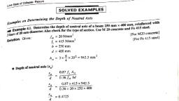
Page 1 :
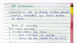
INTRODUCTION, Surveying-Main Division of Surveying--Measurements and their Units-InstruPinci, ments used for taking measurements-General Classification of Surveys-Basic, No.1., in, ples of Surveying-Work of a Surveyor-Precision Surveying-Exercise, , 1.1. Surveying-Definition and Object:, Surveying, , the, measurements in the horizontal and vertical, drawn to convenient reduced size on papers, , is the art of determining relative, , surface of the earth by taking, plane. The measurements are, known as maps or plans., , deals with the, The part of surveying which, on, and the, , Vplane is, are, , known, , as, , levelling, , papers, , positions of objects on, , measurements in the verticl, which these measurements, , drawn are called sections and elevations., , Surveying and levellmg are, , considered to be two different, , operations, , but in the wider sénse, the term surveying includes levelling., or a plan of the area, The main obyect of surveying is to obtain a map, has been practised from, surveyed. The art of surveying and map making, , the very ancient times., , The earliest surveys known' were, , performed only, , the boundaries of land, but their application, for the purpose of establishing, the time has progressed. Now-ahas become increasingly important as, such as a road,, any engineering project, days for the purpose of designing, scheme etc., an engineer would, railway, canal, water supply or sanitary features of the earth's surface in, first item, the, Tequire to study, as the very, and prepare a map of that area. The, which the project is to be located,, is based upon the accurate and complete, of any engineering project, with the, SUCcess, must be thhoroughly familiar, , SUrvey work., , An, , engineer theretore,, , principies and practice of surveying., , 1.2. Main Division of Surveying:, Surveying, , following, may be divided into the, , 1. Plane Surveying., 2. Geodetic Surveying., , two main classes:
Page 2 :
SURVEYING, A TEXT BOOK OF, , AND LEVELLIN, , Therefore, a line joining any, generally assumed to be a spheroid'., circle and not a straial., an arc of a great, points on the surface of the carth is, horizontal, a, plane, and ini, line. Bul a survey plan is a projection upon, must, be horizontal, drawn, construction all linear and angular measurements, , MEAN SPHEROIDAL SURFACE OF EARTH, ACTUAL SURFACE OF EARTH, , SPHERICAL TRIANGLE, PLANE TRIANGLE, PLANE ANGLE, SPHERICAL ANGLE, , 3, , INTRODUCTION, , 1. Plane Surveying. The earth is somewhat elliptical in nature hue is, , the Great Trigonometrical, agencies such as in India, it is conducted by, Survey (G.T.S.) department of India., 1.3. Measurements and their Units, linear and angular, In surveying, a surveyor has to generally deal with, measure, , planes. Linear, distances, as horizontal, known, are, horizontal, plane, ments taken in the, distances., vertical, whereas those taken in the vertical plane are called, and vertical, Similarly the angular measurements are horizontal angles, angles when taken in the horizontal and vertical planes respectively., measurements both in the horizontal and vertical, , Linear Measurements. There are two main systems of measure, , ments, , 1. M.K.S. (Metre, kilogram, second) or Metric System., 2. F.P.S. (Foot, Pound, second) or British System., The unit of length is a metre in M.K.S. system and a foot it, F.P.S. system. Previously India followed F.P.S. system of measure, the, ments but from 1956, according to the Weights and Measures Act,, , 18 km, , 18.1 km, , When the surveys extend over limited areas, the difference2 in length, between the arc and the subiended chord for any two points on the earth is, , Metric system has become the only recognised system in India. Therefore, a metre is the basic unit of length now-a-days and the units of area and, volume are derived from it. The units of length, area and voiume in, Metric system and their conversion to British system are given in the, , of the earth is neglected assuming the earth's surface to be plane, are called, plane surveys. The degree of accuracy obtained in this type of surveying is, , following tables, , Fig. 1.1, , very small and can be neglected. The surveys, where the 'effect of curvature, , comparatively low. Generally areas less than 260 sq. km (100 sq. miles) are, ureated as plane. However, the controlling factor should be the, degree of, accuracy required rather than the area of the survey. The scope and use of, plane surveying is very wide as it is employed in majority of surveys, conducted for the purpose of Engineering works., 2. Geodetic Surveying. When the, surveys extend over large areas or, the degree of accuracy required is, great, the curvature of the earth cannot, be ignored. Those sunveys, where the, curvature of the earth is taken into, account, are called Geodetic Sunveys., They are also known as Trigonometrical surveys as uhey involve the, knowledge of, , Table 1.1. Units of Length, , 10 Millimetres, 10 Centimetres, , 10 Decimetres, , (dm) or 100 cm, , = I metre, , 10 Metres, , (m), , = 1 Decametre, , 10 Decametres, , (dam) or 100 m, , = 1 Hectometre, , 10 Hectometres, , (hm) or 1000 m, , = 1 Kilometre, , ., , The, , calculation work is much, simplified if the earth, spheroid instead of its actual elliptical shape., 2 The difference in length between the are and the, , surface of the earth is, in 91 km., , only abxvut, , 0.1, , m, , in 18.2 km. 0.3, , is, , assumed, , sublended chord, , m, , to, , be, , m, , (cm), , (dm), (m), (dam), (hm), (km), , I foot = 0.3048 m, , I mile, , 1.6093 Km, Table 1.2 Units of Area, (Sq. mm), , = 1 Sq. Centimetre, , (Sq. cm), , 100 Sq Centimeters, , (Sq. cm), , = I Sq. Decimetre, , (Sq. dm), , 100 Sq. Decimetres, , (Sq. dm) or, , 100 Sq. Millimetres, , a, , on the, , in 54.5 km, and 0.5, , = 1 Decimetre, , Conversion: l inch = 2.54 cm, , Trigonometry during, , different operations., Geodetic Surveying is generally, to locate the, widely distant, control points for different surveys to beadopted, conducted in between these, It requires the use of, points., very refined instruments as well as methods of, observation and adjusunent. It is conducted, only through Government, , = 1 Centimetre, , (mm), (cm), , 100 Sq. Metres, , 10 Sq. em, , = 1 Sq. metre, , (Sq. m), , (Sq.m.), , = 1 Are, , (a), (ha), , i00 Ares, , (a) or 10* Sq. m, , = I Hectare, , MO0 IHectares, , ha)or 10° Sq. m, , =, , I, , Sq., , Kilometre, , (Sq. km)
Page 3 :
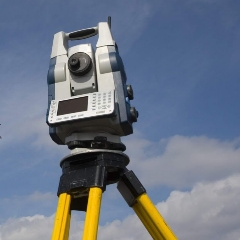
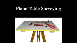
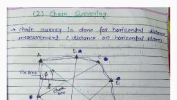
ELLING, , Coversion: 1 Sq. inch =64516, Sq. . =0.0929, , Sq. cm, , INTRODUCTION, , Sq.m, , ISq. mile = 2.59 Sq. Km, I acre, , 1.5,, , According to the instrument used. such as, , Table 1.3 Units of Volume, 1000 cu millimetres, , (cu. mm), , 100 cu. oentimetres (cu. cm), 1000 cu. derimetres (cu. dm) or, , Comversion, , I çu. inch, , 10 cu., , General Classification of Survoys, , Surveys may be classified in different ways:, , 0.4047 hectare, , =, , em, , =, , I cu., , =, , l, , =l, , cu., cu., , Chain Survey, (ii) Compass Survey, (ii) Plane table Survey, , centimetre (cu. cm), decimetre (cu dm), metre (cu. m), , (iv) Theodolite Survey, etc., 2., , 16.387 cu. em., , =, , copper, coal etc. within the earth's crust, , VIcu. ft =0.0283 cu. m., , Angular Measurements., , equal to the angle subtended, length to its radius., radians, I nght angie, A degree, , is, , =, , (ii), , A adian is the unit of, plane, at the centre of a, circle by an, , 100 grades or 90, , I minute, , =, , 4., , taking Measurements:, , The instruments, commonly used for taking surveying measurements, may be divided into the, following main classes:, 1. Instruments used for, ranging and laying out survey lines such as, ranging rods. line ranger, cross-staff,, , optücal square etc., , 2. Instrumcnts used for direct, measurements of, tape, steel band etc., , lengths such às chain,, , 3. Instruments used for, measurement of, tacheometer, subtense bar, Electronic Distance length indirecly such as, Measuring Instruments etc., 4., , Instruments used for detennining direction, of lines such as, ic compass, box-sextant,, theodolite etc., 5., , Instruments used for measuring slopes and, , level etc., 6., , 7., , prismat-, , heights such as clinometer,, , used for, , surveying and ploting simultaneously such as', , Instruments, , used for, , surveying by photographic means such as pho-, , to-theodolite., , i) Traverse Survey., According to the place of work, such as, Land Survey for objects on earth's surface, ), (i) Hydrographical or Marine Survey for objects under water., (i) Aerial Survey by Aeroplane in air., , Land Survey can be further sub-divided into the following classes, (a) Topographical Survey. This is used for determining the natural, features of the country such as lakes, rivers, hills, woods and nallahs etc., and also the artificial objects such as canals, railways, roads, towns and, , villages etc., Tals S, 2500, :10Q000, b) Cadasfral Survey. This is usually ploted to a larger scale than, Additional details such as boundaries of ficlds, houses and other property are determined. 3S00 1:1000d, (c) Ciry Survey. This is performed in connection with town planning, schemes such as drainage, water supply etc. and for laying out plots, , topographical survey., , roads, streets etc., , .hhhd) Engineering Survey. This is camied outfor determining the fea, sibility of any engineering project and collection of field-data as required, for the design etc. Doai lud draucis otan Ensiniinin Rreset inn, 1.6 Basic, , Principles of Surveying:, , The following two basic principles of surveying should be kept in, , Instruments, , plane table., , According to the method employed. such as, , Triangulation Survey., , 60 seconds ("), , Instruments used for, , Geologial Survey to determine different strata in the earth's, , (iv) Military Survey to determine points of strategic importance., , degrees., , =, , (), , gold., , (ii) Archaeological Survey to trace customs or relics of the past., 3, , rnght angles, , as, , crust., , angle and is, arc equal in, , the basic unit of, angle used in India., ), 60 minutes (), , 1 degree, , 1.4., , =2, , According to the purpose of Survey, such as, (i) Mine Survey to explore the mineral wealth such, , view while determining the relative positions of points on the surface of, , theearth, , 1. Determining sultable method for Locating a Point. Itisalways, points ir the field and to measure the distance, , pra ticable to select two
Page 4 :
BOOK OF, , between them. These can, be, a, , SURVEYING, , AND LEVELLI, LLING, , convenient position. From represented on paper by two points, points others can be located these initial points also known as placed., by two suitable, drawn in their relative, refere, in the, positions on the shect.measurements, tum to fix the, Points so obtained ficld an, and, positions of others., serve, e, in, The common, methods of locating a, two reference, points such as A and B point such as C with respect, are, , B, , illustrated in fig. 1.2., , to, , INTRODUCTION, 2., , essential, , Working, to, , from whole, , establish, , to the, , part. 1In surveying an area, it 1s, system of control points with great, points can then be established by less precise, , first of all, , a, , precision. Minor control, methods and the details can be, located afterwards by the method triangulation or traversing between the control points. This way theot minqo, errors are automatically, controlled and localised and do not accumulate., On, the other hand, if we work from, part to the whole, the small, magnified and become uncontrollable at the end., , 8, , errors are, , Work of a Surveyor:, , 1.7., , 90, , The work, , of a surveyor can be divided into the following three parts, , 1. Field-work, , 2. Office-work., 3. Care and, , adjustment of instruments., taking measurements for details, record-, , 1. Field-work. It consists in, , A (c), , (d), , ing field-notes and setting out of works., , A, , 2. Office-work. It consists in, preparing maps, plans and sections, from the data collected in the field and also calculating the areas and, , (a), , volumes and designing the various structures., , Fig. 1.2., , Distances AC, , and, are measured,, and C is, intersection point of two arcs BC, plotted as the, with centres A and B, and radii the measured, distances. This method is, , (b), , Perpendicular, the, , ploted by, is, , used for, , use, , of, , much used in chain, , CD and, , a set, , locating details., , distance, , surveying., , AD or, , BD measured and, , square. This method is temed, , (c) Distance AC and the, , as, , C is, , offsetting and, , angle BAC are measured, and C is, , 3. Care and adjustment of Instruments. The surveyor must be, thoroughly familiar with the instruments which he wil be called upon to, He must also know the methods of, ments., , use., , testing, , and, , adjusting, , the instnu-, , Delicate and very costly instruments such as a theodolite, a level etc., must be handled with great care and accuracy. Even a minor, injury is, liable to make them out of order and the same can only be set to the, , This method is used by, in, , original position by costly and time consuming repairs. Before taking the, instrument out from the box, the corect position of its vanious parts should, , ABC and BAC are, measured, and C is, or by solution of, by a protriangle ABC. This method plotted, is, much, used in, triangulation for very extensive work., (e) Angle BAC and distance BC, are, and C is plotted by, protractor or trigonometrically. This methodmeasured,, is of minor, in exceptional cases., utility and is used, One or more than one of the, above methods may be, same survey, employed in the, to the instruments, according, available for the angular and, linear measurements. A, survey may therefore be conducted in, several, ways by different combinations of methods, and instruments, upon the purpose of survey, the degree of, depending, accuracy required, the nature of, the country, the extent of the, survey and the time available., , experienced while replacing the instrument The instrument should be set, on its well spread and stable tripod stand and should never be left unguard-, , means of, , a, , proractor, , Iraversing., (d) Angles, tractor, , or, , trigonometrically., , plotted, , be, , noted and if necessary a rough sketch be made so hat no difficulty is, , ed. The instrument should be protected from the sun, dust and rain etc., , The lenses should always be kept clean and the movable parts should, be cleaned and lubricated with refined watch oil at frequent intervals., A thorough knowledge of the theory of surveying and skill in its, go0od judgement and organisation are the principal requisites of a, practice,, good surveyor which can only be acquired by taking keea interest in the, field-work., , 1.8. Preclsion in Surveying, of, The, accuracy required in survey work mainly depends upon, the purpose of survey and the scale of plotting. Since the land in cities, , degree
Page 5 :
9, , A TEXT BOOK OF SURVEYING AND LEVELLING, , is much more valuable than that in rural areas, so gm, reate, accuracy is required in the survey of urban areas and measurements, be made up to the nearest centimetre. But in the survey of fields, mea, and, , mu, , ing upto smaller fractiors is sheer wastage of time. They may be taken, the, nearest decimetre. At the same time, it may be pointed out thate, accurate surveys take much time and are more expensive. Summing, the various factors, the accuracy required in survey-Work depends, up, , thefollowing:, i), ii), , the nature and size of the country to be surveyed,, the instruments and methods of observation, , employed,, , (vi) the time available and,, , plotting., , Keeping in view the above factors,, , the surveyor may decide upon the, , method and instruments most suitable for, , particular case. By properly, planning and methodically conducting the survey-work, we can attain, the, required degree of accuracy at a minimum cost and in a minimum time., , Exercise No. 1, , Assess what you have learnt, Fill in the blankS, G), , Surveying, , is the, , the earth., , (i) The part of, , art, , of, , surveying, , plane is known as, (i) The main oibject of, , determining-, , -of objects on the surface of, , which deals with measurements in the vertical, , survoying, , is, , to, , obtain-, , -of the area to be sur, , veyed., iv) Generally areas less than- a r e treated, as plane., (v) The survey, where curvature of the earth is taken into, , account is, , known, X(vi) nradians =, grades=, degrees., (vii) In survey, wben work is done from, to the whole, the smaller, part, errors, are, as-, , (vii) By properly planning and, methodically conducting the, work,, can attain the, required degree of accuracy at a--costsurvey, and in atime., Ans., , (a), (b), , (ii), , 7., , (v) the funds available, the scale used for, , done ?, ? What for is it, 2. What is surveying, following:, mean by the, 3. (i) hat do you, Linear Measurements., Angular Measurements., , Name the, , instruments, , area., , (iv) the souroes of eror,, , (vii), , Theory Problems., , used for, , taking above, , measurements., , measurements., units of, , about the, (ii) Explain briefly, surveying?, 4. How will you classify, them briefly?, surveyor. Explain, duties, surveying an, ofa, 5. Name the, observed while, be, to, fundamental principles, & 94), 6. Explain the, (Pb. U. 1987, 91, , (i) the purpose of the survey,, , 1., , INTRODUCTION, , towns, , wo, , (i) relative position (ii) levelling (ii), map or plan (iv) 260 sq. km., Geodetic, (vi) 2; 200; 180 (vii), magnified, and (viii) minimum; minimum,(V, , How can you obtain, , surveying?, the required precision in
 Learn better on this topic