Page 1 :
AGRO-235 Rainfed Agriculture and Watershed Management, , Theory notes on, Course No. AGRO-235 (1+1=2), Rainfed Agriculture and Watershed Management, , Dr. Jivan R. Katore, Assistant Professor, Agronomy, College of Agriculture, Nagpur, , Teaching Schedule, Sr. No., 1, 2, 3, 4, 5, 6, 7, 8, 9, 10, , Topic, Rainfed agriculture: Introduction, types, History of, rainfed agriculture and watershed in India, Problems and prospects of rainfed agriculture in India, Soil and climatic conditions prevalent in rainfed areas, Soil and water conservation techniques, Drought: types, effect of water deficit on physiomorphological characteristics of the plants, Crop adaptation and mitigation to drought, Water harvesting: importance, its techniques, Efficient utilization of, water through soil and crop management practices, Management of crops in rainfed areas, Contingent crop planning for aberrant weather conditions, Concept, objective, principles and components of, watershed management, , Page No., , REFERENCE BOOKS, 1., 2., 3., 4., 5., 6., , Principles of Agronomy : S. R. Reddy, Sustainable Development of Dryland Agriculture in India. : R.P.Singh, Dry farming technology in India. : P.Rangaswamy, Dryland Resources and Technology, Vol. 8 L.L.Somani, W.Kausal, Physiological aspects of dryland farming. U.S. Gupta, Dry farming in India. N.V. Kanitkar, S.R. Sirur and Gokhale Agronomy by S.C. Panda 2006., Agrobios Publication, New Delhi., 7. Guide for competitive agriculture by R.K. Sharma, N. Pandey, A.P. Singh, R.S. Maitry, 8. A Lecture note on Dryland farming and watershed management by Dr. T.Y. Reddy and Dr., G.P. Reddy, ANGARU, Hyderabad, , Prepared by: Dr. Jivan R. Katore, Assistant Professor, Agronomy, College of Agriculture, Nagpur, Page | 1
Page 2 :
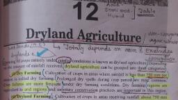
AGRO-235 Rainfed Agriculture and Watershed Management, , 1. Rainfed agriculture: Introduction, types, History of rainfed, Agriculture and Watershed in India, Introduction, Dryland agriculture has a distinct place in Indian agriculture, occupying around 67 %, of the cultivated area, contributing to nearly 44 % of foodgrains and supporting 40 % of, human and 60 % of livestock population. Most (80-90 %) of the pulses, oilseeds and millets, are confined to dryland ecosystems., Dryland Agriculture refers to growing of crops entirely under rainfed conditions‖., Based on the amount of rainfall received, dryland agriculture can be grouped into three, categories:, 1. Dry Farming: Cultivation of crops in areas where average annual rainfall is less than 750, mm per annum. Crop failure is most common due to prolonged dry spells during the crop, period. These are arid regions with a growing season (period of adequate soil moisture) less, than 75 days. Moisture conservation practices are necessary for crop production., 2. Dryland Farming: Cultivation of crops in areas receiving rainfall from 750 to 1150 mm per, annum. In spite of prolonged dry spells crop failure is relatively less frequent. These are semi, arid tracts with a growing period between 75 and 120 days. Moisture conservation practices, are necessary for crop production. However, adequate drainage is required especially for, vertisols or black soils., 3. Rainfed Farming : Cultivation of crops in regions receiving more than 1,150 mm per, annum. Crops are not subjected to soil moisture stress during the crop period. Emphasis is, often on disposal of excess water. These are humid regions with growing period more than, 120 days., , Prepared by: Dr. Jivan R. Katore, Assistant Professor, Agronomy, College of Agriculture, Nagpur, Page | 2
Page 3 :
AGRO-235 Rainfed Agriculture and Watershed Management, , Dry Farming, Dryland Farming and Rainfed Farming, Particular, Rainfall/annum, (mm), Moisture, Availability, Crop growing season, Growing region, Cropping, systems, Dry spells, Crop failure, Constraints, Measures, required, , Dry Farming, < 750, , Dryland Farming, 750 - 1150, , Rainfed Farming, > 1150, , Acute shortage, , Shortage, , Enough, , < 75 days, , 75 – 120 days, , > 120 days, , Arid, Single crop/ Inter, cropping, Most common, More frequent, , Semi arid, Single crop/, multi, cropping, Less frequent, Less frequent, Wind erosion/ water, erosion, Moisture conservation, Practices & drainage, for vertisols, , Humid, Inter cropping/, double cropping, No occurrence, Rare, Water erosion, , Wind erosion, Moisture, conservation, practices, , Proper drainage, require, , The chronology of events in dryland agricultural research in India is as follows., Year, 1920, 1923, 1933, 1934, 1935, 1944, 1953, 1954, 1959, 1970, 1972, 1976, 1983, 1985, 1990, 2006, , chronology of Events, Scarcity tract development given importance by the Royal Commission on, Agriculture, Establishing Dryland Research Station at Manjri (Pune), Research Stations established at Bijapur and Solapur, Research Stations established at Hagari and Raichur, Research Station established at Rohtak (Punjab), Monograph on dry farming in India by N.V. Kanitkar, Bombay,Hyderabad, Establishing Central Soil Conservation Board, Establishing Soil and water conservation research institute at Dehradhun,, with Soil Conservation Centres, Central arid zone research institute (CAZRI), Jodhpur, Research Centres established under AICRPDA in 23 locations, Establishment of ICRISAT, Hyderabad, Establishment of Dryland Operational Research Projects, Starting of 47 model watersheds under ICAR, Central Research Institute for Dryland Agriculture (CRIDA) at Hyderabad, National watershed development project for rainfed agriculture, (NWDPRA), National Rainfed Area Authority (NRAA), , Prepared by: Dr. Jivan R. Katore, Assistant Professor, Agronomy, College of Agriculture, Nagpur, Page | 3
Page 4 :
AGRO-235 Rainfed Agriculture and Watershed Management, , 2. Problems and prospects of rainfed agriculture in India, Problems or constraints for crop production in dry farming regions Most of the, cropping in the arid and semi arid regions continues to be under rainfed conditions. A, majority of the farmers are small farmers with meager resources. The poor resource, base permits only low input subsistence farming with low and unstable crop yields. The, low productivity of agriculture in dry farming regions is due to the cumulative effect of, many constraints for crop production. The constraints can be broadly grouped in to, 1) Inadequate and Uneven Distribution of Rainfall, In general, the rainfall is low and highly variable which results in uncertain crop, yields. Besides its uncertainty, the distribution of rainfall during the crop period is, uneven, receiving high amount of rain, when it is not needed and lack of it when crop, needs it., (a) Cultivation of low water required crops, (b) Short duration crops grown, (c) Providing life saving irrigation, 2) Long Gap in Rainfall, (a) Increase in seed rate to obtain more population, (b) Spraying of urea solution, (c) Providing life saving irrigation at critical growth stages, (d) Weeding and intercultural operations, 3) Early Onset of Monsoon, (a) Cultivate Pearlmillet, Sesamum etc., 4) Late Onset of Monsoon, Due to late onset of monsoon, the sowing of crops are delayed resulting in poor, yields., (a) Alternate crop & varieties: Castor (Aruna), greengram, cowpea, sunflower, (b) Dry sowing, , Prepared by: Dr. Jivan R. Katore, Assistant Professor, Agronomy, College of Agriculture, Nagpur, Page | 4
Page 5 :
BS Publication, , AGRO-235 Rainfed Agriculture and Watershed Management, , (c) Pre sowing, (d) Seed soaking/treatment, (e) Transplanting of one month old Bajra seedlings., (f) Complete weed control, (g) Grow legumes/oilseed crops in place of cereals, (h) Most suitable crop for this condition is Sunflower., 5) Early Cessation of Rains, Sometimes the rain may cease very early in the season exposing the crop to, drought during flowering and maturity stages which reduces the crop yields, considerably, (a) Select short duration varieties, (b) Using mulching/mulches, (c) Life saving irrigation applied, (d) Decrease in plant population, 6) Prolonged Dry Spells, Long breaks in the rainy season is an important feature of Indian monsoon., These intervening dry spells when prolonged during crop period reduces crop growth, and yield and when unduly prolonged crops fail., (a) If dry spell in 10 days of sowing, resowing, (b) If mild moisture stress at 30-35 days after sowing, thinning of alternate rows of Sorghum, and Pearlmillet, (c) If severe moisture stress at 30-35 days afer sowing, cu ing of sorghum and Pearlmillet and, rationing, (d) If moisture stress at blooming stage, cutting of sorghum and Pearlmillet and rationing, (e) Breaking of monsoon for short while, shallow inter cultivation for eradicating weeds/soil, mulch, (f) Wider spacing for moisture conservation, , Prepared by: Dr. Jivan R. Katore, Assistant Professor, Agronomy, College of Agriculture, Nagpur, Page | 5
Page 6 :
BS Publication, , AGRO-235 Rainfed Agriculture and Watershed Management, , (g) Spray of 2 per cent urea after drought period is useful for indeterminate, crops like castor, pigeonpea and groundnut., (h) Soil mulching to reduce evaporation losses, (i) In situ water harvesting, (j) Life saving irrigation, (k) Weed control to save water, nutrients etc., 7) Low moisture retention capacity, The crops raised on red soils, and coarse textured soils suffer due to lack of, moisture whenever prolonged dry spells occur due to their low moisture holding, capacity. Loss of rain water occurs as runoff due to undulating and sloppy soils., 8) Low fertility of soils, Soil fertility has to be increased, but there is limited scope for extensive, use of chemical fertilizers due to lack of adequate soil moisture., , Prepared by: Dr. Jivan R. Katore, Assistant Professor, Agronomy, College of Agriculture, Nagpur, Page | 6
Page 7 :
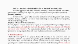
BS Publication, , AGRO-235 Rainfed Agriculture and Watershed Management, , 3. Soil and climatic conditions prevalent in rainfed areas, I) Soils: - Out of total cultivable land in M.S. 87 per cent area comes ur rained., Soils of drought prone areas of M.S. area derived from the be igneous rock Basalt, commonly known as Deccan trap. The colours of soil vary from reddish brown to, dark gray black and are called verti. The soils exhibit a definite to posegence of, ridge medium dear 122 - 90 cm depth) soils on sloped land deep soils (more than, 90 cm meen) end of watershed. The distribution of very shallow, shallow, medium, deep and deep soils in drought prone areas of M.S. is about 10,20,45 and 25%, respectively. They usually under lined partially decomposed rock locally known as, murrum which overlies parent material. On account of more or less complete, absence of leaching the soils are base saturated. The exchangeable calcium is, predominant cation. The free lime is reserve is fairly high (3 to 10%) and at places, excessive quantities of time nodules accumulate. The problematic soils viz. saline,, saline sodic land sodic soils do occur in patches in low lying areas., As regards the fertility status, the soils are generally low in organic carbon, (0.35 to 0.5%) total nitrogen (0.03 to 0.05%) low to medium available phosphate, (10 to 30 kg p2O5/ha) and high available potash (300 to 750 kg K2O/ha). Usually, micro-nutrient deficiencies are not observed in dry land crops. However in eroded, soils, crop like groundnut have shown some response to boron application. Cereal, crops give fairly good response to nitrogenous fertilizers while oilseeds and, legumes give good response to phosphatic fertilizers., Soils exhibit adverse physical characters because of high clay content (35, to 65%) of type clay mineral. The soils exhibit high volume expansion when moist, and shrink when dry. The infiltration rate of soils is moderately slow (0.5 to 0.9, cm/ha). During the process of shrinkage, wide land deep cracks are developed, even up to Murrum strata in medium deep soils. The crack development, accelerates the soil moisture loss from the deeper layers (phases). Further soils, exhibit varying degree of erosion depending on the slope, tillage operations and, cropping season. The soils classed as moderate to high erodible. Hence soil and, water conservation is a pre - requisite for successful cropping. Limited soil depth, puts limitations on availability of water and nutrients for cropping intensity., Usually soils having less than 45 cm depth are useful for Kharif crops as they are, unretentive of soil moisture. Intermittant wetting due to frequent rainfall during, June to Aug helps to mature crops on such soils. Soils having depth more than 45, cm have high moisture storage and retentive capacity. Under dry land to bring the, soil moisture in the available range (i.e. above PWP) the rainfall required is quite, high since the precipitation in the early part of monsoon is quite inadequate the, Prepared by: Dr. Jivan R. Katore, Assistant Professor, Agronomy, College of Agriculture, Nagpur, Page | 7
Page 8 :
BS Publication, , AGRO-235 Rainfed Agriculture and Watershed Management, , medium deep soils (beyond 45 cm deep) usually do not have adequate moisture, for sowing. It is only due to receipt of about 200 mm of rains during September, the medium deep and deep soils are adequately moistened for Rabi cropping., Hence Rabi cropping is predominant and medium deep and despoils one grown, with Rabi crops., The moisture storage capacity of soil mainly depends on clay content and soil, depth. However, city content is generally above 45 percent in medium deep and, deep soil the moisture depletion of soil depends on the moisture held in the soil at, different tensions. The soil moisture is always below the moisture at 15 bar (PWD), which ultimately results in failure of crops in dry land agriculture., II) Climate: Weather, which is part of climate, plays an important role in crop, planning in dry farming area. Out of the several elements of weather, rainfall has, key position in success of dry farming., In dry land areas, South West Monsoon brings the bulk of rainfall. The South West, Monsoon is followed by North East Monsoon which supplements to South West, Monsoon are the main source of rainfall. There are four types of rainfall, characterized by the nature in different parts of India. Generally, the rainfall is, scanty, erratic and ill distributed. The draught prone area in Maharashtra State, Covers about 1/3 of the total area of the state. The climate in this is usually hot, and PE (Potential Evaporation) is for in excess of the precipitation is classified as, semiarid e.g. Annual precipitation at Solapur is about 7/22 mm. but PE is about, 1300 mm annually resulting in deficient 60%., III) Rainfall features :- The annual Average rainfall varies from 400 mm to 700, mm. Year to year fluctuations are so much that there is no guaranteed of fixed, quantity of rainfall. Uncertain and ill distributions of rainfall are two qualities, which makes the Rainfed farming difficult. Rainfall starts in lated June to Early July., There is depression during late July and early August Again there is good, rainfall in late August and September. The rainfall totally recedes but mid October., The probability of rainfall is more than half of the normal fairly good (P = 0.58), during September., IV) Dry spells: - It is another rainfall feature. Breaks in monsoon a normally, experienced (observed) during rate July and August. They month extend by 2, week to 13 weeks at a stretch. A break is defined as period receiving less than 15, mm rainfall in consecutive weeks. The normal rainfall during the week being more, Prepared by: Dr. Jivan R. Katore, Assistant Professor, Agronomy, College of Agriculture, Nagpur, Page | 8
Page 9 :
BS Publication, , AGRO-235 Rainfed Agriculture and Watershed Management, , than 50 mm. A duration of break month than 4 week and frequently more than 3, times usually results in fatures than 4 weeks and frequently more than 3 times, usually results in faitures crops., Variation in the rainfall with in the district is also observed. In Solapur,, particularly variation in annual precipitation is noticed from 500 mm in western, part to about 700 mm in eastern parts., V) Water availability period: - Water availability depends on rainfall and PE., Humid (when rainfall exceeds PE) and moist (when rainfall is less than PE but, exceeds PET) period together provides congenial weather for active crop growth., VI) Wind velocity: - Wind velocity is generally hitch during July and August. If wind, velocity exceeds 18 - 20 km./hr. Such period coincided with dry spell. Hence, Evapotranspiration is at high degree. If velocity is low the lowest evaporation rates, are observed during November and December., VII) Bright sunshine hours: - Bright sunshine is usually experienced during months, of Jan. and Feb. At Solapur it is about 8 to 9 hours. During April and May the sky is, usually have with more dust particles, lowest bright sunshine is noticed during, Aug. (4 to 5 hours). This indicates the cloudy weather but no rainfall., VIII) Humidity: - Humidity is high during July and Sept. During Feb. to May it is low., During dry spell, less relative humidity is noticed. Evaporation demands are also, accelerated with high temperature and low humidity., IX) Temperature: - a Maximum temperature exceeds 410 C during late April and, early May. Minimum temp. is noticed during December. Lowest weekly minimum, temperature is about 14 to 150C. Generally climate is semi and with mild winter, and hot summer. Crop like wheat and gram requiring longer cool period hence do, poor while prolonged cold weather however, Jowar suffers considerably., , Prepared by: Dr. Jivan R. Katore, Assistant Professor, Agronomy, College of Agriculture, Nagpur, Page | 9
Page 10 :
BS Publication, , AGRO-235 Rainfed Agriculture and Watershed Management, , 4. Soil and water conservation techniques, Broadly speaking, the practical methods of soil and water conservation fall into two, important classes, viz. Agronomic measures and Engineering measures., A) AGRONOMIC MEASURES, Agronomic practices for soil and water conservation help to intercept rain drops, and reduce the splash effect, help to obtain a better intake of water rate by the soil by, improving the content of organic matter and soil structure, help to retard and reduce, the overland run-off through the use of contour cultivation, mulches, dense-growing, crops, strip-cropping and mixed cropping. Agronomical measures are adopted where, land slope is <2 per cent, which are followings:, 1. Conservation Tillage, 2. Deep tillage, 3. Conservation Farming, 4. Contour Farming, 5. Mulching, 6. Growing of cover crops, 7. Strip cropping, 8. Mixed cropping, 1) CONSERVATION TILLAGE, , , , , , , , , This umbrella term can include reduced tillage, minimum tillage, no-till, direct, drill, mulch tillage, stubble-mulch farming, trash farming, strip tillage, ploughplant., With advanced soil conservation programmes, the concept of conservation tillage is, the main theme of the recommendations for cropland., , The application is mainly in mechanized high production farming with good, rainfall, or for the control of wind erosion where there is large-scale mechanized, cereal production. It is less applicable to low input level crop production, or, subsistence agriculture., The principles are equally effective in any conditions - to maximize cover by, returning crop residues and not inverting the top soil, and by using a high crop, density of vigorous crops., , Prepared by: Dr. Jivan R. Katore, Assistant Professor, Agronomy, College of Agriculture, Nagpur, Page | 10
Page 11 :
BS Publication, , AGRO-235 Rainfed Agriculture and Watershed Management, , , , Conservation tillage also has the advantage of reducing the need for terraces or other, permanent structures. However there are several disadvantages which hinder the application, of conservation tillage in semi-arid conditions:, , , , Dense plant covers may be incompatible with the well-tested strategy of using low, plant populations to suit low moisture availability;, , Crop residues may be of value as feed for livestock;, , , , Planting through surface mulches is not easy for ox-drawn planters although there, may be no problem with hand job planters., , 2), , DEEP TILLAGE, , , , One of the reasons for low yields in semi-arid areas is the limited amount of, moisture available to crop roots., , , , The available moisture will be increased if the rooting depth is increased and it, has been shown that in some cases deep tillage can help, for example on the dense sandy, soils., , , , Deep tillage is beneficial for some crops but not all, and on some soils but not all., , , arid areas., , Deep tillage requires greater draught power which is usually in short supply in semi-, , , , Ripping or subsoiling can be beneficial, either to increase the porosity of the soil, or, to break a pan which is reducing permeability., , , , The deep placement of fertilizer can also be used to encourage more rooting at, depth, but again the application of this technique to subsistence farming will be difficult., , 3), , CONSERVATION FARMING, , , , It includes any farming practice which improves yield, or reliability, or decreases, the inputs of labour or fertilizer, or anything else leading towards improved land husbandry,, which we have defined as the foundation of good soil conservation., , , , It includes strip cropping, crop rotations, alternate cropping, mixed cropping and, interplanting, surface and mulching, organic mulches, deep planting of varieties, dry seeding, etc., , 4), , CONTOUR-FARMING, , During intense rain storms, the soil cannot absorb all the rain as it falls. The, excess water flows down the slope under the influence of gravity. If farming is done up and, down the slope, the flow of water is accelerated, because each furrow serves as a rill. The, major part of the rain is drained away without infiltrating into the soil. The top fertile soil,, , , , Prepared by: Dr. Jivan R. Katore, Assistant Professor, Agronomy, College of Agriculture, Nagpur, Page | 11
Page 12 :
BS Publication, , AGRO-235 Rainfed Agriculture and Watershed Management, , along with plant nutrients and seeds, is washed off. All this results in a scanty and uneven, growth of a crop., , , , , , ―A simple practice of farming across the slope, keeping the same level, as far, as possible is technically called contour-farming‖., , Advantages: 1) Contour-farming reduces run-off and prevents soil erosion, as compared with the up and down cultivation in the major groups of soils, in India, viz. Alluvial soils, black soils and deep lateritic soils.2) Contourfarming conserves soil fertility and increases crop yields., , Counter cultivation, 5) MULCHING, , , , , , Surface mulches are used to prevent soil from blowing and being washed, away, to reduce evaporation, to increase infiltration, to keep down, to, improve soil structure and eventually to increase crop yields., Inter-culture kills weeds and produces five or seven cm thick soil mulch which, helps to reduce evaporation from the top soil., It also breaks the surface crust which forms after each downpour., , Prepared by: Dr. Jivan R. Katore, Assistant Professor, Agronomy, College of Agriculture, Nagpur, Page | 12
Page 13 :
BS Publication, , AGRO-235 Rainfed Agriculture and Watershed Management, , Straw mulch, , Black polyethylene mulch, , 6) GROWING OF COVER CROPS, , , , , , Cultivated legumes, in general, furnish a better cover and hence better, protection to cultivated land against erosion than ordinary cultivated crops., The crops and the cropping systems will naturally vary from region to region,, depending on the soil and climatic conditions., The mostly preferred cover crops are green gram, black gram, cowpea,, groundnut etc., , 7) STRIP CROPPING, Strip cropping is the system of growing alternate strips of erosion, permitting crops (row crop such as maize, jowar, bajra, cotton etc) and erosion, resisting crops (close growing crops such as green gram, black gram, moth,, groundnut etc.) in the same field. This practice reduces the velocity of runoff and, checks the eroded soil from being washed away., , , , Strip cropping is essentially for controlling the run-off erosion and thereby, maintaining the fertility of the soil is now universally recognized. Strip cropping,, in effect, employs several good farming practices, including crop rotation,, contour cultivation, proper tillage stubble mulching, cover cropping, etc., , Strip cropping is of the following different forms :, , (i) Contour strip cropping, (ii) Field strip cropping, (iii) Wind strip cropping, (iv) Permanent or temporary buffer strip cropping, , Prepared by: Dr. Jivan R. Katore, Assistant Professor, Agronomy, College of Agriculture, Nagpur, Page | 13
Page 14 :
BS Publication, , AGRO-235 Rainfed Agriculture and Watershed Management, , (i), , , , , , , , Contour Strip Cropping, Contour strip cropping is the growing of soil exposing and erosion, permiting crops in strips of suitable widths and placed across the slopes on, contour, alternating with strip of soil protecting and erosion resisting, crops., Contour strip cropping shortens the length of the slope, checks the, movement of runoff water, helps to desilt it and increases the absorption, of rainwater by the soil., Further, the dense foliage of the erosion resistant crops prevents the rain, from beating the soil surface directly., It is advisable to rotate the strip planting by sowing a non-resistant crop,, following an erosion resistant crop and vice versa., , (i) Groundnut, Moth bean (Phaseolus acontifolius) and Horse gram, (Dolichos biflorus) are the most efficient and suitable crops for checking erosion., (ii) The normal seed-rates of leguminous crops, other than groundnut, do, not give sufficiently dense canopies to prevent rain drops from beating the soil, surface in many cases. The seed rate should be trebled., (iii) The most effective width of the contour strips for cereals, such as, Jowar and Bajra, is 21.6 m and for the intervening legume, it is 7.2 m., , Prepared by: Dr. Jivan R. Katore, Assistant Professor, Agronomy, College of Agriculture, Nagpur, Page | 14
Page 15 :
BS Publication, , AGRO-235 Rainfed Agriculture and Watershed Management, , Strip Widths as Suitable for Erosion Permitting and Resistant Crops on, Different Slopes, Slope, , Width of ErosionPermitting Crops, 1/2 per cent and below, 45.0 m, Between 1 and 2 per cent, 24.0, Between 2 and 3 per cent, 13.5, (ii) Field Strip Cropping, , Width of ErosionResistant Crops, 9.0, 6.0, 4.5, , It is the planting of field crops in more or less parallel strips across fairly uniform, slopes, but not on exact contours. This system is useful on regular slopes and with soils, of high infiltration rates., (iii) Wind Strip Cropping, It consists of planting tall growing crops such as jowar, bajra, maize, and short, growing crops in alternately arranged straight and long, but relatively narrow,, parallel strips laid out right across the direction of the prevailing wind, regardless, of the contour., (iv) Permanent or Temporary Buffer Strip Cropping, , , , , , In the case of permanent or temporary buffer strip cropping, permanent strips of, grasses or legume or mixture of grass and legume are laid either in badly eroded, areas or in areas that do not fit into a regular rotation, i.e. steep or highly, eroded, slopes in fields under contour strip cropping., These strips do not form part of the rotation practiced in normal strip cropping, and they are generally planted with perennial legumes, grasses or shrubs on a, permanent or temporary basis., , Prepared by: Dr. Jivan R. Katore, Assistant Professor, Agronomy, College of Agriculture, Nagpur, Page | 15
Page 16 :
BS Publication, , AGRO-235 Rainfed Agriculture and Watershed Management, , 8) MIXED CROPPING, , , , , Mixed cropping is the growing of 2 or more crops simultaneously in the, same field without any definite row pattern. This is done by mixing their, seeds., Important objectives of mixed cropping are a better and continuous cover, of the land, good protection against the beating action of the rain, almost a, complete protection against soil erosion and the assurance of one or more, crops to the farmer., , Mixed cropping, B) ENGINEERING MEASURES, Engineering/Mechanical measures are construction of mechanical barriers, across the direction of the flow of water to retain the runoff for reducing soil and, water loss. They play a very vital role in controlling erosion on agricultural land., They are generally adopted where land slope is >2 per cent and to supplement, the agronomical practices when the later alone are not adequately effective., These measures include:, 1. Bunding, 2. Terracing, 2. Trenching, 3. Basin-listing, 4. Subsoiling, The main objectives of the mechanical measures for controlling erosion are:, (i) To increase the time of concentration by intercepting the run-off and thereby, providing an opportunity for the infiltration of water, and, Prepared by: Dr. Jivan R. Katore, Assistant Professor, Agronomy, College of Agriculture, Nagpur, Page | 16
Page 17 :
BS Publication, , AGRO-235 Rainfed Agriculture and Watershed Management, , (ii) To divide a long slope into several short ones so as to reduce the velocity of the, run-off and thus prevent erosion., 1) BUNDING, Bund is an earthen embankment constructed to control runoff and minimize, soil erosion by reducing the length of slope., (a) Contour Bunding, , , , , , Contour bunding is most popular mechanical measure to control soil, erosion and conserve moisture in arid and semi-arid areas with high, infiltration and permeability., This practice consists in making a comparatively narrow-based, embankment at intervals across the slope of the land on a level that is, along the contour., It is commonly adopted on agricultural land up to a slope of about 6 per cent, and in areas where average annual rainfall is < 600 mm., , Contour Bunding, (b) Graded Bunding/Channel Terraces, , , , In graded bunding water flows in graded channels constructed on up-stream, side of bunds and leads to safe outlet on grassed water ways., Graded bunds may be narrow-based or broad-based. A broad-based, graded terrace consists of a wide-low embankment constructed on the, lower edge of the channel from which the soil is excavated. The channel is, excavated at suitable intervals on a falling contour with a suitable, longitudinal grade., , Prepared by: Dr. Jivan R. Katore, Assistant Professor, Agronomy, College of Agriculture, Nagpur, Page | 17
Page 18 :
BS Publication, , AGRO-235 Rainfed Agriculture and Watershed Management, , , , It is adopted at about 2-10 per cent land slope and in areas where average, annual rainfall is > 600 mm., , Graded Bunding, Grassed Waterways, , , , , , , , , Grass waterways are natural or constructed watercourses covered with, erosion resistant grasses and are used to dispose surface water from the, crop land. They are constructed along the slope of the land., Grassed waterways are associated with channel terraces for the safe disposal, of concentrated runoff, thereby protecting the land against rills and gullies., , Grass waterways are also used to handle natural runoff or to carry the, discharge from contour furrows, diversion channels or to serve as, emergency spillway in farm ponds., The suitability of a grass was based on the cover it gave, the ease with which it, was established and the forage yield obtained from it., Panicum repens was the best suited grass, followed by Brachiara mutica,, Cynodon plectostachyus, Cynodon dactylon and Paspalum notatum., , 2) TERRACING, A terracing is a combination of ridge and channels built across the slope., This is generally practiced in steep hill slope., , Prepared by: Dr. Jivan R. Katore, Assistant Professor, Agronomy, College of Agriculture, Nagpur, Page | 18
Page 19 :
BS Publication, , AGRO-235 Rainfed Agriculture and Watershed Management, , Terracing, (a) Bench Terracing, , , , , , , , , , , , Bench terrace consists of construction of step like fields along the contour, by half cutting and half filling. Original slope of the land is converted into, level fields and thus all hazards of erosion are eliminated., The vertical drop may vary from 60 to 180 cm, depending upon the slope, and soil conditions, as also on the economic width required for easy, cultural operations., The material excavated from the upper part of the terrace is used in filling the, lower part., A small ‗shoulder‘ bund of about 30 cm in height is also constructed along the, outer edge of the terrace., It is generally practiced on steep sloping (16-33 per cent) and undulated land., It helps to bring sloping land into different level strips to enable cultivation., , Bench terraces may be ‗table top‘ or sloping outward or inward with or, without a slight longitudinal grade, according to the rainfall of the tract medium, poor or heavy, and the soil and the subsoil are fairly absorptive or, poorly permeable, , (i) Table top (level): adopted in medium rainfall (750 mm) areas, permeable soils, and ideal where irrigation facility is available., (ii) Sloping inward: adopted in heavy rainfall (>750 mm) areas, (iii) Sloping outward: adopted in low rainfall (<750 mm) areas, (b) Zing Terracing, Zing terracing is adopted in 3-10 per cent land slope., , Prepared by: Dr. Jivan R. Katore, Assistant Professor, Agronomy, College of Agriculture, Nagpur, Page | 19
Page 20 :
BS Publication, , AGRO-235 Rainfed Agriculture and Watershed Management, , Prepared by: Dr. Jivan R. Katore, Assistant Professor, Agronomy, College of Agriculture, Nagpur, Page | 20
Page 21 :
BS Publication, , AGRO-235 Rainfed Agriculture and Watershed Management, , , , , It is constructed in medium to deep soils in high rainfall areas., The aims of constructing zing terracing is:, , To cut down the length of slope, To harvest the runoff from upper areas for the benefits of, crops grown in lower areas., 3) TRENCHING, Trenching is made along the contour for soil & moisture conservation and, afforestation purpose., , , , , , , , , The size of trenches – 60cm x 48cm, Spacing between trenches – 10-30 meter, , Trenches are half refilled with excavated materials and remaining half of the, soil forms the spoil bank., The remaining water in the trenches help in conserving the moisture and, provides benefits for sowing and planting., , Trenching, 4) BASIN-LISTING, Basin-listing consists in making of small interrupted basins along the, counter with a special implement, called a basin lister. Basin-listing helps to retain, rainwater as it falls and is specially effective on retentive soils having mild slopes., , Prepared by: Dr. Jivan R. Katore, Assistant Professor, Agronomy, College of Agriculture, Nagpur, Page | 21
Page 22 :
BS Publication, , AGRO-235 Rainfed Agriculture and Watershed Management, , Prepared by: Dr. Jivan R. Katore, Assistant Professor, Agronomy, College of Agriculture, Nagpur, Page | 22
Page 23 :
BS Publication, , AGRO-235 Rainfed Agriculture and Watershed Management, , 5) SUBSOILING, This method consists of breaking the hard and impermeable subsoil with, a subsoiler to conserve more rainwater by improving the physical conditions of a, soil. This operation, which does not involve soil inversion and promotes greater, moisture penetration into the soil, reduces both run-off and soil erosion. The, subsoiler is worked through the soil at a depth of 30-60 cm at a spacing of 90-180, cm. Sub soling by tractor drawn chisel plough at 2 m horizontal interval is the, most effective insitu soil and water conservation practice for early establishment, and improving the pasture. It will also increase the efficiency of work and a large, area can be covered in a few cost and limited time., , MICROCATCHMENTS FOR SLOPING LANDS, It is useful for in-situ moisture conservation and erosion control for tree, crops., Prepared by: Dr. Jivan R. Katore, Assistant Professor, Agronomy, College of Agriculture, Nagpur, Page | 23
Page 24 :
BS Publication, , AGRO-235 Rainfed Agriculture and Watershed Management, , MICROCATCHMENTS, Salient Features, , , , , , , , , Slope ranges from 2 –8 per cent, Around 16 m2 area surrounded by 15-20 cm dirtwall, Bund height - 30 to 45 cm., Soil type - Light to moderate texture, Insitu moisture conservation with staggered planting, Suitable for dry land Horticulture & Agroforestry, , Microcatchment, , CHECK DAM, , , , , , , , , , , A low weir normally constructed across the gullies., Constructed on small streams and long gullies formed by erosive activity of, flood water., It cuts the velocity and reduces erosive activity., , The stored water improves soil moisture of the adjoining area and allows, percolation to recharge the aquifers., Spacing between the check dams water spread of one should be beyond the, water spread of the other., Height depends on the bank height, varies from a metre to 3 metre and length, varies from less than 3m to 10m., , Prepared by: Dr. Jivan R. Katore, Assistant Professor, Agronomy, College of Agriculture, Nagpur, Page | 24
Page 25 :
BS Publication, , AGRO-235 Rainfed Agriculture and Watershed Management, , PERCOLATION POND: To augment the ground water recharge, Salient Features, , , , , , , , , , Shallow depression created at lower portions in a natural or diverted stream, course., Preferable under gentle sloping stream where narrow valley exists., Located in soils of permeable nature., , Adaptable where 20-30 ground water wells for irrigation exist with in the zone, of influence about 800 – 900m., Minimum capacity may be around 5000 m3 for the sack of economy., Also act as silt detention reservoir., , Prepared by: Dr. Jivan R. Katore, Assistant Professor, Agronomy, College of Agriculture, Nagpur, Page | 25
Page 26 :
BS Publication, , AGRO-235 Rainfed Agriculture and Watershed Management, , BROAD BEDS AND FURROWS, The broad bed and furrow system is laid within the field boundaries. The, land levels taken and it is laid using either animal drawn or tractor drawn ridgers., Maize/Sorghum is grown in beds and rice in furrows., Salient Features, , , , , , Conserves soil moisture in Dryland., Controls soil erosion., Acts as a drainage channel during heavy rainy days., , Classification of Gullies, Any system of gullies has an independent catchment, with a regular stream, which has been termed the ―drainage system‖. In each drainage system, it has, been observed that gullies with defined side slopes, bed width and depths occur in, a regular order. In the upper reaches of the drainage system, the gullies are wide, and shallow, with varying side slopes. The middle part of the drainage system is, usually deeper, wider and has uniform side slopes normally up to about 15 per, cent. The lower portion of the drainage system which is nearer to the main river is, usually very deep, has steep side slopes and is associated with intricate branch, gullies., The gullies have been classified as follows:, Symbol, G1, G1, G1, , Description, Very small gullies, Small gullies, Medium gullies, , G1, , Deep and narrow gullies, , Specifications, Up to 3 m deep and bed width 18 m., Up to 3 m deep and bed width >18 m., Depth between 3-9 m and bed width > 18, m, m deep with < 18m bed width, , Prepared by: Dr. Jivan R. Katore, Assistant Professor, Agronomy, College of Agriculture, Nagpur, Page | 26
Page 27 :
BS Publication, , AGRO-235 Rainfed Agriculture and Watershed Management, , UNIVERSAL SOIL LOSS EQUATION, A = RKLSCP, where,, A: Predicted soil loss (tonne/acre/year), R: Rainfall and runoff factor, K: Soil erodibility, S: Steepness (land slope), C: Soil cover management, P: Erosion control practices, Design of Composite Check Dams, The design discharge (maximum run-off) through the drainage channel is, computed from the empirical formula, Q = 0.0028 C.I.A., where,, Q: Run-off in cubic metres per second (m3/sec)., C: Run-off coefficient (a value calculated by constants of slope and soil type)., I: Rainfall intensity in mm/hr., A: Watershed area in hectare., The length of the spillway is determined from the formula:, Q = 1.70 LH3/2, where,, Q: Run-off in cubic metres per second (m3/sec)., L: Length of the weir notch in metres., H: Height in metres of water flow above the spillway level., , Prepared by: Dr. Jivan R. Katore, Assistant Professor, Agronomy, College of Agriculture, Nagpur, Page | 27
Page 28 :
BS Publication, , AGRO-235 Rainfed Agriculture and Watershed Management, , Institute Involved in Soil and Water Conservation, 1. Central S oil and Water Conservation Research and Training Institute, (CSWCRT), Dehradun, Uttarakhand., 2. Soil Conservation Research Demonstration and Training Centre, Hyderabad, (AP)., , In situ soil moisture conservation, Storage of rainfall or rain water at the place where rainfall occurs for its, effective usage is known as in situ moisture conservation. This can be achieved by, different measures. Improving the soil surface conditions to increase infiltration of, rainfall and reduction of runoff are the two basic requirements in dry lands. Hence, land configuration determines the ease with which water can enter the soil. The, different in situ moisture conservation practices which result in changed land, configuration are as follows., Ridges and furrows: The field must be formed into ridges and furrows. Furrows of, 30-45 cm width and 15-20 cm height are formed across the slope. The furrows, guide runoff water safely when rainfall intensity is high and avoid water, stagnation. They collect and store water when rainfall intensity is less. It is suitable, for medium deep to deep black soils and deep red soils. It can be practiced in wide, row spaced crops like cotton, maize, chillies, tomato etc. It is not suitable for, shallow red soils, shallow black soils and sandy/ gravelly soils. It is not suitable for, broadcast sown crops and for crops sown at closer row spacing less than 30 cm., Since furrows are formed usually before sowing, sowing by dibbling or planting, alone is possible., , Tied ridging: It is a modification of the above system of ridges and furrows, wherein the ridges are connected or tied by a small bund at 2-3 m interval along, the furrows to allow the rain water collection in the furrows which slowly, percolated in to the soil profile, , Prepared by: Dr. Jivan R. Katore, Assistant Professor, Agronomy, College of Agriculture, Nagpur, Page | 28
Page 29 :
BS Publication, , AGRO-235 Rainfed Agriculture and Watershed Management, , Broad bed furrows (BBF): This practice has been recommended by ICRISAT for, vertisols or black soils in high rainfall areas (> 750 mm). Here beds of 90-120cm, width, 15 cm height and convenient length are formed, separated by furrows of 60, cm width and 15 cm depth. When runoff occurs, its velocity will be reduced by, beds and infiltration opportunity time is increased. The furrows have a gradient of, 0.6%. Crops are sown on the broad beds and excess water is drained through, number of small furrows which may be connected to farm ponds. It can be formed, by bullock drawn or tractor drawn implements. Bed former cum seed drill enables, BBF formation and sowing simultaneously, thus reducing the delay between, receipt rainfall and sowing., , Broad bed furrow has many advantages over other methods., • It helps in moisture storage, • Safely dispose off surplus surface runoff without causing erosion, • Provide better drainage facilities, • Facilitate dry seeding, , Prepared by: Dr. Jivan R. Katore, Assistant Professor, Agronomy, College of Agriculture, Nagpur, Page | 29
Page 30 :
BS Publication, , AGRO-235 Rainfed Agriculture and Watershed Management, , • It can accommodate a wide range of crop geometry i.e. close as well as wide, row spacing., • It is suitable for both sole cropping and intercropping systems., • Sowing can be done with seed drills., Dead furrows: At the time of sowing or immediately after sowing, deep furrows of, 20 cm depth are formed at intervals of 6 to 8 rows of crops. No crop is raised in, the furrow. The dead furrows can also be formed between two rows of the crop,, before the start of heavy rains (Sep – Oct). It can be done with wooden plough, mostly in red soils. The dead furrows increase the infiltration opportunity time., , Compartmental bunding: Small bunds of 15 cm width and 15 cm height are, formed in both directions to divide the field into small basins or compartments of, square or rectangular shape of 6 x 6 m to 10 x 10 m size using bund former .They, are useful for temporary impounding of rain water which facilitates high, infiltration resulting in high moisture storage in the soil. Recommended for black, soils with a slope of 0.5 to 1%. Maize, sunflower, sorghum perform well in this, type of bunding., , Scooping: Scooping the soil surface to form small depressions or basins help in, retaining rain water on the surface for longer periods. They also reduce erosion by, trapping eroding sediment. Studies have shown that runoff under this practice can, be reduced by 50 % and soil loss by 3 to 8 t /ha., Prepared by: Dr. Jivan R. Katore, Assistant Professor, Agronomy, College of Agriculture, Nagpur, Page | 30
Page 31 :
AGRO-235 Rainfed Agriculture and Watershed Management, , Inter plot water harvesting: Water is drawn from part of a small catchment and, used in lower portion for crop production. There may be 1: 1 cropped: catchment, area or 1:2 catchment: cropped area., , Zingg terracing or conservation bench terracing: These are developed by, A.W.Zingg, in USA. Zingg terracing is practiced in low to medium rainfall areas in, black soils with contour bunds. It is a method of land shaping where lower one, third portion of the land adjacent to the contour is leveled to spread to the runoff, water coming from the remaining two third portion of the field .This rainfall, multiplication technique ensures at least one good crop in one third area even in, low rainfall years. Usually during medium rainfall years water intensive crops (like, paddy) are cultivated in the levelled portion (receiving area) while dry crops are, cultivated in the unlevelled (donor) area., , Prepared by: Dr. Jivan R. Katore, Assistant Professor, Agronomy, College of Agriculture, Nagpur, Page | 31
Page 32 :
AGRO-235 Rainfed Agriculture and Watershed Management, , 5. Drought: types, effect of water deficit on physio-morphological, characteristics of the plants, Introduction, Low rainfall or failure of monsoon rain is a recurring feature in India. This, has been responsible for droughts and famines. The word drought generally, denotes scarcity of water in a region. Though, aridity and drought are due to, insufficient water, aridity is a permanent climatic feature and is the culmination of, a number of long term processes. However, drought is a temporary condition that, occurs for a short period due to deficient precipitation for vegetation, river flow,, water supply and human consumption. Drought is due to anomaly in atmospheric, circulation., Aridity Vs. Drought, Particulars, Duration, , Aridity, Permanent feature, , Factors, , Culmination of many long, term, processes , considers all, climatic, features, Description of Climate, , Aspect described, , Drought, Temporary condition of, scarcity of varying, duration, Caused by deficient, rainfall, , Description of Water, availability, , Definition of drought, There is no universally accepted definition for drought., a) Early workers defined drought as prolonged period without rainfall., b) According to Ramdas (1960) drought is a situation when the actual seasonal, rainfall is deficient by more than twice the mean deviation., c) American Meteorological Society defined drought as a period of abnormally dry, weather sufficiently prolonged for lack of water to cause a severe hydrological, imbalance in the area affected., Classification of drought:, , Prepared by: Dr. Jivan R. Katore, Assistant Professor, Agronomy, College of Agriculture, Nagpur, Page | 32
Page 33 :
AGRO-235 Rainfed Agriculture and Watershed Management, , Drought can be classified based on duration, nature of users, time of, occurrence and using some specific terms., 1. Based on duration, a. Permanent drought: This is characteristic of the desert climate where sparse, vegetation growing is adapted to drought and agriculture is possible only by, irrigation during entire crop season., b. Seasonal drought: This is found in climates with well defined rainy and dry, seasons. Most of the arid and semiarid zones fall in this category. Duration of the, crop varieties and planting dates should be such that the growing season should, fall within rainy season., c. Contingent drought: This involves an abnormal failure of rainfall. It may occur, almost anywhere especially in most parts of humid or sub humid climates. It is, usually brief, irregular and generally affects only a small area., d. Invisible drought: This can occur even when there is frequent rain in an area., When rainfall is inadequate to meet the evapo-transpiration losses, the result is, borderline water deficiency in soil resulting in less than optimum yield. This occurs, usually in humid regions., 2. Based on relevance to the users (National Commission on Agriculture, 1976), a) Meteorological drought: It is defined as a condition, where the annual, precipitation is less than the normal over an area for prolonged period (month,, season or year)., b) Atmospheric drought: It is due to low air humidity, frequently accompanied by, hot dry winds. It may occur even under conditions of adequate available soil, moisture. It refers to a condition when plants show wilting symptoms during the, hot part of the day when transpiration exceeds absorption temporarily for a short, period. When absorption keeps pace with transpiration the plants revive. (Mid day, wilt)., c) Hydrological drought: Meteorological drought, when prolonged results in, hydrological drought with depletion of surface water and consequent drying of, reservoirs, tanks etc. It results in deficiency of water for all sectors using water., This is based on water balance and how it affects irrigation as a whole for bringing, crops to maturity., , Prepared by: Dr. Jivan R. Katore, Assistant Professor, Agronomy, College of Agriculture, Nagpur, Page | 33
Page 34 :
AGRO-235 Rainfed Agriculture and Watershed Management, , Agricultural drought (soil drought): It is the result of soil moisture stress due to, imbalance between available soil moisture and evapotranspiration of a crop. It is, usually gradual and progressive. Plants can therefore, adjust at least partly, to the, increased soil moisture stress. This situation arises as a consequence of scanty, precipitation or its uneven distribution both in space and time., d), , 3. Based on time of occurrence, a) Early season drought: It occurs due to delay in onset of monsoon or due to long, dry spells after early sowing, b) Mid season drought: Occurs due to long gaps between two successive rains, andmstored moisture becoming insufficient during the long dry spell., c) Late season drought: Occurs due to early cessation of rainfall and crop water, stress at maturity stage., 4. Other terms to describe drought, a) Relative drought: The drought for one crop may not be a drought situation for, another crop. This is due to mismatch between soil moisture condition and crop, selection. Eg. A condition may be a drought situation for growing rice, but the, same situation may not be a drought for growing groundnut., b) Physiological drought: Refers to a condition where crops are unable to absorb, water from soil even when water is available, due to the high osmotic pressure of, soil solution due to increased soil concentration, as in saline and alkaline soils. It is, not due to deficit of water supply., Important causes for agricultural drought are, • Inadequate precipitation, • Erratic distribution, • Long dry spells in the monsoon, • Late onset of monsoon, • Early withdrawal of monsoon, • Lack of proper soil and crop management, Effect of drought on crop production, , Prepared by: Dr. Jivan R. Katore, Assistant Professor, Agronomy, College of Agriculture, Nagpur, Page | 34
Page 35 :
AGRO-235 Rainfed Agriculture and Watershed Management, , a) Water relations: Alters the water status by its influence on absorption,, translocation and transpiration. The lag in absorption behind transpiration results, in loss of turgor as a result of increase in the atmospheric dryness., b) Photosynthesis: Photosynthesis is reduced by moisture stress due to reduction, in Photosynthetic rate, chlorophyll content, leaf area and increase in assimilates, saturation in leaves (due to lack of translocation)., c) Respiration: Increase with mild drought but more serve drought lowers water, content and respiration., d) Anatomical changes: Decrease in size of the cells and inter cellular spaces,, thicker cell wall , greater development of mechanical tissue. Stomata per unit leaf, tend to increase., e) Metabolic reaction: All most all metabolic reactions are affected by water, deficits., f) Hormonal Relationships: The activity of growth promoting hormones like, cytokinin, gibberlic acid and indole acetic acid decreases and growth regulating, hormone like abscisic acid, ethylene, etc., increases., g) Nutrition: The fixation, uptake and assimilation of nitrogen is affected. Since, dry matter production is considerably reduced the uptake of NPK is reduced., h) Growth and Development: Decrease in growth of leaves, stems and fruits., Maturity is delayed if drought occurs before flowering while it advances if drought, occurs after flowering., i) Reproduction and grain growth: Drought at flowering and grain development, determines the number of fruits and individual grain weight, respectively. Panicle, initiation in cereals is critical while drought at anthesis may lead to drying of, pollen. Drought at grain development reduces yield while vegetative and grain, filling stages are less sensitive to moisture stress., j) Yield: The effect on yield depends hugely on what proportion of the total dry, matter is considered as useful material to be harvested. If it is aerial and, underground parts, effect of drought is as sensitive as total growth. When the, yield consists of seeds as in cereals, moisture stress at flowering is detrimental., When the yield is fibre or chemicals where economic product is a small fraction of, total dry matter moderate stress on growth does not have adverse effect on, yields., , Prepared by: Dr. Jivan R. Katore, Assistant Professor, Agronomy, College of Agriculture, Nagpur, Page | 35
Page 36 :
AGRO-235 Rainfed Agriculture and Watershed Management, , 6. Crop adaptation and mitigation to drought, Crop Adaptation:, The ability of crop to grow satisfactorily under water stress is called, drought adaptation., Adaptation is structural or functional modification in plants to survive and, reproduce in a particular environment., Crops survive and grow under moisture stress conditions mainly by two, ways:, (i) Escaping drought and (ii) drought resistance, 1. Escaping Drought, Evading the period of drought is the simplest means of adaptation of, plants to dry conditions. Many desert plants, the so called ephemerals, germinate, at the beginning of the rainy season and have an extremely short life period (5 to, 6 weeks) which is confined to the rainy period. These plants have no mechanism, for overcoming moisture stress and are, therefore, not drought resistant., Germination inhibitors serve as safety mechanism., In cultivated crops, the ability of a cultivar to mature before the soil dries is, the main adaptation to growth in dry regions. However, only very few crops have, such a short growing season to be called as ephemerals. Certain varieties of pearl, millet mature within 60 days after sowing. Short duration pulses like cowpea,, greengram, blackgram can be included in this category. In addition to earliness,, they need drought resistance because there may be dry spells within the crop, period of 60days. The disadvantage about breeding early varieties is that yield is, reduced with reduction in duration., 2. Drought Resistance, Plants can adopt to drought either by avoiding stress or by tolerating stress, due to different mechanisms. These mechanisms provide drought resistance., 3. Avoiding Stress, Stress avoidance is the ability to maintain a favourable water balance, and, turgidity even when exposed to drought conditions, thereby avoiding stress and, , Prepared by: Dr. Jivan R. Katore, Assistant Professor, Agronomy, College of Agriculture, Nagpur, Page | 36
Page 37 :
AGRO-235 Rainfed Agriculture and Watershed Management, , its consequences. A favourable water balance under drought conditions can be, achieved either by: (i) conserving water by restricting transpiration before or as, soon as stress is experienced; or (ii) accelerating water uptake sufficiently so as to, replenish the lost water., Strategies for drought management, The different strategies for drought management are discussed under the, following heads., 1. Adjusting the plant population: The plant population should be lesser in, dryland conditions than under irrigated conditions. The rectangular type of, planting pattern should always be followed under dryland conditions. Under, dryland conditions whenever moisture stress occurs due to prolonged dry spells,, under limited moisture supply the adjustment of plant population can be done by, a) Increasing the inter row distance: By adjusting more number of plants within, the row and increasing the distance between the rows reduces the competition, during any part of the growing period of the crop. Hence it is more suitable for, limited moisture supply conditions., b) Increasing the intra row distance: Here the distance between plants is, increased by which plants grow luxuriantly from the beginning. There will be, competition for moisture during the reproductive period of the crop. Hence it is, less advantageous as compared to above under limited moisture supply., 2. Mid season corrections: The contingent management practices done in the, standing crop to overcome the unfavourable soil moisture conditions due to, prolonged dry spells are known as mid season conditions., a) Thinning: This ca be done by removing every alternate row or every third row, which will save the crop from failure by reducing the competition, b) Spraying: In crops like groundnut, castor, redgram, etc., during prolonged dry, spells the crop can saved by spraying water at weekly intervals or 2 per cent urea, at week to 10 days interval., c) Ratooning: In crops like sorghum and bajra, ratooning can practiced as mid, season correction measure after break of dry spell., 3. Mulching: It is a practice of spreading any covering material on soil surface to, reduce evaporation losses. The mulches will prolong the moisture availability in, the soil and save the crop during drought conditions., , Prepared by: Dr. Jivan R. Katore, Assistant Professor, Agronomy, College of Agriculture, Nagpur, Page | 37
Page 38 :
AGRO-235 Rainfed Agriculture and Watershed Management, , 4. Weed control: Weeds compete with crop for different growth resources are, seriously under dryland conditions. The water requirement of most of the weeds, is more than the crop plants. Hence they compete more for soil moisture., Therefore the weed control especially during early stages of crop growth reduce, the impact of dry spell by soil moisture conservation., 5. Water harvesting and life saving irrigation: The collection of runoff water, during peak periods of rainfall and storing in different structures is known as, water harvesting. The stored water can be used for giving the life saving irrigation, during prolonged dry spells., 6. Use of wind breaks and shelterbelts: Wind breaks are any structures that, obstruct wind flow and reduce wind speed while shelterbelts are rows of trees, planted for protection of crops against wind. The direction from which wind is, blowing is called windward side and direction to which wind is blowing is called, leeward side. Shelterbelts are planted across the direction of wind. They do not, obstruct the wind flow completely. Depending upon their porosity, certain, amount of wind passes through the shelterbelts while the rest deflects and, crosses over the shelterbelts. It thus reduces wind speed without causing, turbulence. The protection offered by the shelterbelts is dependent on the height, of central tree row in the shelterbelts. Generally, shelterbelts give protection from, desiccating winds to the extent of 5 to 10 times their height on windward side and, up to 30 times on leeward side. Due to reduction in wind speed, evaporation, losses are reduced and more water is available for plants. The beneficial effects of, shelterbelts are seen more clearly in drought years. In addition, shelterbelts, reduce wind erosion., , Prepared by: Dr. Jivan R. Katore, Assistant Professor, Agronomy, College of Agriculture, Nagpur, Page | 38