Page 1 :
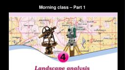
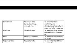
Landscape analysis through maps SS2-4, What is Topographical maps?, -Topographical maps depict in minute detail all the natural and man made features on the earth's surface., -These maps contain the important surface features such as the undulations of the terrain, rivers, other, water bodies, forests, agricultural land, barren land, villages, towns, and transport and telecommunication, systems., -These maps show both natural and man-made features in details., -Topographic maps are large-scale maps., -Large-scale maps are maps depicting detailed information of relatively small areas., Who is responsible for making the Topographic map in India? Why?, -Survey of India, -Certain restrictions have been imposed on the use of topographic maps of strategic regions owing to the, national security concerns., Uses of topographical maps?, -Analysis of the physical and the cultural features of the earth surface., -For military operations and the preparation of military maps., -Identification and studying of the natural and the cultural resources of a region as part of economic, planning., -For urban planning., -To understand land use., -To understand the topography., -For resource conservation and allocation., -For computerized form of maps - GIS, What are the essential elements for a topographic maps reading?, -Knowledge of the numbering scheme,, -Locational aspects,, -The conventional signs and symbols,, -The elevation and slope of the terrain,, -The methods of their representation are very essential for comprehending topographic maps., Layout and numbering of toposheets, -Toposheets for the whole world have been prepared in several sheets of same size and shape., -The whole world is picturised in 2222 sheets as follows., -There are 1800 sheets for regions between 60° North and South latitudes., -420 sheets for regions between 60° and 88° latitudes in both hemispheres and 2 sheets for, both the poles., -The numbering of India's toposheets are done on the basis of the India and Adjoining Countries Map, Series., -As each of the maps in this series is in 1:1000000 scale, these are known as million sheets., Million sheets, -Each of the maps in troposheets is in 1:1000000 scale., -These are known as million sheets., -The million sheets covering 4° latitudinal and 4° longitudinal extent are given numbers from 1 to 105., -These numbers are known as index numbers(55)., 1
Page 2 :
Degree sheets, -Each million sheet is divided into 16 parts in the order A, B, C, D, .......... up to P., -For example, the million sheet numbered 55 is divided into 16 parts as 55A, 55B, 55C, …..55P., -Each of these sheets with 1° latitudinal and longitudinal extent is prepared in 1:250000 scale., -These sheets are prepared in 1:250000 scale., Minutes sheets, -Degree sheets are divided into 16 parts and each has 15 minutes longitude and longitude., -These are Minutes sheets., -Minutes sheets are numbered as 1, 2, 3, .... 16 (55D/1, 55D/2,.......55D/16)., -These sheets are prepared in 1 : 50000 scale., Conventional signs and symbols in Troposphere, -various features on the Earth's surface are represented in topographic maps using different colours and, symbols., -The colours and symbols used in the toposheets are internationally accepted., -So the maps prepared in one country can be easily understood and analysed by the people of another., conventional colours used to represent different geographic features, Feature, -Latitudes and longitudes, -Non perennial water bodies, -Railway lines, telephone and telegraph lines, -Boundary line, , Black, , -Oceans, rivers, wells, tube wells......, (perennial water bodies), , Blue, , -Forests, -Grasslands, -Trees and shrubs, -Orchards, , Green, , -Cultivable land, , Yellow, , -Barren land, , White, , -Settlements, roads, paths, , Red, , -Grid lines (eastings, northings and their numbers), , Red, , -Contour lines and their values, , Brown, , -Sand dunes and sand hills, , Brown, , Colour, , Grid reference, -In Toposheets include red lines in the north-south and east-west directions., -The north-south lines are called eastings., -And east-west lines are called northings., -The grids formed jointly by the eastings and the northings are called reference grids., -Grid reference is the determination of the position of the terrestrial objects using this grid., , 2
Page 3 :
-In 1:50000 toposheets each grid with 2 cm width & 2 cm breadth covers an area with 1 kilometre length, & 1 kilometre breadth on the earth's surface., -Eastings and Northings lines are used to solve the difficulty of accurately determining the location of, small geographical features on toposheets., Eastings, -These are north-south lines., -Their value increases towards the East., -The value of the easting immediately left to the geographic features is considered for identifying a, location., Northings, -These are lines drawn in the east-west direction., -Their value increases towards the north., -The value of the northings immediately to the south of the feature in the map is considered for identifying, a location., 4 - figure grid reference, -In the 4 - figure grid reference method, the value of the easting to the immediate left of the feature is to be, written first., -Then the value of the northing just south of the feature is to be written., -This positioning method is known as four-figure grid reference., 6-figure grid reference, -Relatively smaller geographic features are generally located through the 6-figure grid, reference method., -While determining the location of the geographical features the value of the easting to the left of it is to, be written first., -Then divide the area up to the next easting into 10 equal Parts., -Then find the exact division on which the geographical feature is located and write it next to the value of, easting already found., -Now write the value of the northing just below the feature along with the easting's value., -Divide the area up to the next northing as being divided into 10 equal parts., -Then find the exact division on which the feature is located and write it with the values already written., -What is obtained is the exact 6 figure grid reference of the geographical feature., Contour Lines, -Contours are imaginary lines drawn on maps connecting those places having equal elevation from the sea, level., -The respective altitude will be marked with each contour line., -These are called contour values., -The closely spaced contours represent steep slopes and the widely spaced contours, represent gentle slopes., What are the three things can be assessed from the contour lines in topographic maps?, -Altitude of the place, -Nature of the slope, -Shape of the land form, Intervisibility, - If any two places are mutually visible, then we can establish that these places are intervisible., 3
Page 4 :
- Intervisibility assessment is being applied for erecting electric posts, mobile towers and wireless, transmission towers., - To find out the intervisibility between two place we must draw the shape of geographical feature by, using contour lines., Toposheet interpretation, - Marginal Information/Primary information,, - Physical/Natural features,, - Cultural/Man-made features., These are the different stages of study and interpretation of toposheet., Marginal Information or Primary information., -The general information given outside the margins in topographic maps is known as marginal/primary, information., Marginal Information or Primary information & indicators., - Topo sheet number - (a), - Name of the place represented - (b), - Latitudinal location - (c) 1 , (c) 2, - Longitudinal location - (d) 1 , (d) 2, - Easting - (e) 1 , (e) 2, - Northing - (f) 1 , (f) 2, - Scale of the map – (g), - Contour interval - (h), - Year of survey - (i), - Year of publication - (j), - Agency in charge of survey - (k), Physical features of toposheets, Water bodies such as (-rivers, -streams, -springs, etc) and, -different landforms are the physical features in topographic maps., Cultural features, -Cultural features are man-made objects on troposheet., -Settlements,, -Well,, -Tube well,, -different types of roads,, -boundaries,, -places of worship,, -agricultural lands,, -post office,, -police station,, -bridges,, -wells and tube wells are a few cultural features shown in toposheets., BIJU KK, GHSS TUVVUR, MALAPPURAM, , 4