Notes of BA PART I GEOGRAPHY, Rajasthan Geography & Physical Geography Climate of Rajasthan.pdf - Study Material
Page 1 :
Climate of Rajasthan, , Rajasthan has a sub-monsoon climate from, dry to humid, low rainfall in the western part, of Aravali, high daily and annual climate, low, humidity and climatic climate. Second and, there is arsenic and sub-climatic climate in, the east of Aravali., , Factors affecting the climate - latitudinal, , status, sea level distance, elevation from, , sea level, position and direction of Aravali, mountain ranges etc., , Key Features of the Climate of Rajasthan , 1. Primacy of dry and humid climate, , 2. Inadequate and erratic rainfall, , 3. Annuity distribution of precipitation, , 4. Most rain from June to September, , 5. Due to rain deficiencies and deficiency,, the condition of drought and famine is high., , Rajasthan is located in the north of the, Cancer Line. Hence the state is situated in, the sub-trunk zone. Only a part of Dungarpur, and Banswara district is located in the, tropics., , The Aravalli mountain ranges have divided, Rajasthan into two parts in terms of climate., The Aravalli mountain ranges are not able to, hinder the path due to the direction of the, Mansoon winds, so the manssoni wind is a, direct nickel and can not rain. Thus, the, western region of Aravalli receives short, rains due to being a shadow state., , When sunlight shines directly on the cancer, line, its rays fall flat on Banswara and, slopes on the district of Ganganagar. The _, average annual temperature of Rajasthan is, , 37 degrees to 38 degrees centigrade., , Rajasthan is divided into five parts in terms, of climate., , 1. Dry climate region (0-20 cm), , 2. Semi-humid climate region (20-40 cm), , 3. Sub-climatic climatic region (40-60 cm), , 4. Humid climate region (60-80 cm), , 5. Very Wet Climate Territories (80-100 cm), , 1. Dryland, Area - Jaisalmer, Northern Barmer, Southern, , Ganganagar and western part of Bikaner, and Jodhpur. Average rainfall - 0-20 cm., , 2. Semi-humid climate region, Area - Churu, Ganganagar, Hanumangarh, D., Eastern part of Barmer, Jodhpur and, , Bikaner and western part of Pali, Jalore,, Sikar, Nagaur and Jhusunu., , Average rainfall - 20-40 cm., , 3. Subclass Climate Climate, Area - Eastern part of Alwar, Jaipur, Ajmer,, , Pali, Jalore, Nagaur and Jhusunu and northwestern part of Tonk, Bhilwara and Sirohi., , Average rainfall - 40-60 cm., , 4. Humid Climate, , Areas - Bharatpur, Dhaulpur, Kota, Bundi,, Sawimadhapura, U.P. Udaipur, D.P. Tonk
Page 2 :
and Chittaurgarh, , Average rainfall - 60-80 cm., , 5. Very Wet Climate Territory, , Area - D.P. Kota, Baran, Jhalawar, Banswara,, Pratapgarh, Dungarpur, D.P. Udaipur and, Mount Abu region., , Average rainfall - 60-80 cm., , Fact, , The warmest months of Rajasthan are MayJune and the cold months are DecemberJanuary., , Rajasthan's warmest and coldest district Churu, , The highest daily temperature in Rajasthan, is in the western region., , Rajasthan's highest daily fever with districtJaisalmer, , Rainfall in Rajasthan is 57 cm Whose, distribution is between 10 to 100 cm Is, between. Inadequate and indefinite amount, of uneven distribution of rainfall is the, cause of dry and famine every year in, Rajasthan., , Rainfall in Rajasthan decreases from south, east to northwest. With the Arabian, monsoon winds, there is sufficient rainfall in, the south and south-eastern districts of the, state., , 34 percent of the total rainfall in the state is, in July, 33 percent in the month of August., , Most rain at the district level - Jnalawar, 00 cm), , Minimum rainfall at district level - Jaisalmer, (10 cm), , The average number of days of rains in, Rajasthan is 29., , Maximum number of days of rainfall Jhalawar (40 days), Banswara (38 days), , Minimum number of days of rain - Jaisalmer, (5 days), , Rajesthan's most rainy place - Mount Abe, (120-140 cm) is the place where most days, of rain (48 days) are found., , The number of rainy days increases from, north west to south east., , The lowest humidity in Rajasthan - in the, month of April, , Highest humidity in Rajasthan - in August, , The highest temperature in Rajasthan remains in the month of October., , The lowest rainfall place - Sam (Jaisalmer), Scm, , Rajasthan 50 cm Line splits into two parts., 50 cm The rainfall line is less in the northwest. Whereas in the south east there is, more rainfall., , This is 50 cm Standard line Aravali, Mountain Mala is considered.
Page 3 :
Jhalawar is the district with the highest, Uma in Ralasinan and the lowest district, is Jaisalmer. The highest humidity place in, Rajasthan is Mount Abu and low humidity, Phalodi (Jodhpur)., , The highest hail month in Rajasthan is, March-April and the highest hail is in the, north-eastern region and the district with, the most hailstorm is Jaipur., , Winds in Rajasthan run towards west and, southwest., , Highest wind speed - June month, Slow wind speed - November month, , In the summer the west area area is lesser, than the eastern region., , In the summer, hot winds move from west, side which are called Lu. Due to this lu, the, area of low air pressure is formed here. To., compensate for this low air pressure, the air, comes from the other area (from the high, barrels), which comes up with a lot of dust, and mud, which is called a storm., , The highest number of thunderstorms Sriganganagar (27 days), , Minimum number of storms - Jhalawar (3, days), , In the northern parts of Rajasthan, the, dusted bases are in the month of June and, in the southern parts of May., , In Rajasthan, there is more tufan, (thunderstorms) than before the west., , Humidity, The amount of water vapor present in the, air is called humidity. Relative humidity is, , lowest in March-April and highest in JulyAugust., , Lu, , The dry and extremely hot air that runs in, the desert region is called Lu., , The temperature decreases with elevation, from the sea level. This normal rate of |, Securrence is 165 m 1 degree at the height, of Gr. is., , There is a decrease in temperature in the, south-eastern region from the northwestern part of Rajasthan., , According to the climate classification of, Dr.Bladimir Kopen, Trivartha, Thornewate,, Rajasthan was divided into 4 climatic states., , 1. Aw tropical wet climate region, , 2. BShw semi-arctic arid climate region, , 3. BWhw tropical dry climate region, , 4. CWG Sub-humid Climate Region, , Rajasthan has been divided into the, following ten climate provinces in terms of, agriculture., , 1. dry western plains, , 2. irrigated northern western plains, , 3. Dry partial irrigated western plains
Page 4 :
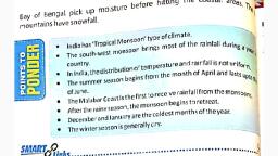
4. Intraflux, , 5. Luni Basin, , 6. Eastern plains (Bharatpur, Dhaulpur,, Karauli district), , 7. Ardha Dry Climate region, , 8. Sub-humid climate region, , 9. Climate Climate, , 10. Extreme Climate Climate, , There are three types of seasons found in, the study of climate in Rajasthan: , 1. Summer: (from March to mid-June), , 2. Rainy Season: (from mid-June to, September), , 3. Winter Season: (November to February), , summer season, , Rajasthan has summer season from March, to mid-June. It has the highest heat in the, months of May and June. Humidity ends in, excess heat. As a result the air goes up, lightly. Therefore, the area of low air, pressure is created in Rajasthan, as a result, of which high air pressure comes from low, fluctuation of air and the speed of the storm, continues in summer., , Rainy Season, , Rajasthan has a rainy season between mid, June and September., , There are three types of monsoons in, Rajasthan., , 1. Bay of Bengal monsoon, , This monsoon enters Rajasthan from the, eastern direction. Due to the entry from the, eastern direction, monsoon winds are, , known as Purabaiyans. This monsoon rains, highest in Rajasthan, with this monsoon, rainfall in the northern, north-eastern, southeastern regions of Rajasthan., , 2. Arabian Sea Monsoon, , This monsoon enters the south-western, direction of Rajasthan, it does not make, much rain in the monsoon rajasthan, because it goes out parallel to Aravali, ranges. The expansion of Aravali ranges in, Rajasthan is from south-west to northeast., If the state of Aravali is expanded from, north-west to south-east in the state then, the highest area in Rajasthan is rains., , The first monsoon of the Arabian Sea enters, Rajasthan, , 3. Mediterranean monsoon, , This monsoon enters Rajasthan from the, western direction. Due to the entry from the, western direction, this monsoon is known, by the nickname of the monsoon of western, busts. This monsoon has rain in the northwest region of Rajasthan. This monsoon, mainly rains in winter. Rainfall in winter is, called Maavath in the local language. This, rain is most beneficial for the wheat crop., These raindrops are known as the golden, drops or the goldsmiths of gold that are, known as bulls., , winter season, , In Rajasthan there is a cold season from, February to February. In these four months,, it is the coldest winter in the month of, January. Due to cyclones in the
Page 5 :
Mediterranean Sea in the wet season, there, is rain in the northern western part of, Rajasthan. Which is called "Mout / Maath", This rain occurs in the month of Magh., Winter rain fall - also called golden drop., This is beneficial for Ravi's crop., , Winds in the state often run west and northwest., , The rain, , The highest rainfall in Rajasthan is from the, , southwest monsoon winds, and the second, , place is the monsoon of Bay of Bengal, third, lace the monsoon of the Arabian Sea, the, , ast place is the monsoon of the, Mediterranean Sea., , Storm names, , Comes from North - Uttara, Uttad, Dharod,, Dharau, , Coming from the South - Luckau, , Coming from East - Purvaiya, Purnai, Purwa,, Aaguti, , Coming from the west - Pichavai, Pachhau,, Pichwa, Purnu., , other, Middle East - Sanjari, , From the middle of the East-South - Rip / Eel, , From the middle of south-west - Samandari, / Samudri, , From the middle of the north-west - the sun, , Daily speed / rotation speed, , Earth leaned 23 1/2 degrees on its axis It, completes one cycle in 23 hours 56 minutes, and 4 seconds with a move of 1610 km /, hour east from west on its axis. This motion, is called rotational motion or daily speed,, due to this it is day to day., , Annual speed / rotation speed, , In order to circumambulate the Sun, 365, days takes 5 hours 48 minutes and 46, seconds, it is called the Earth's annual, motion or rotation speed. The time it takes, to be called the solar year. Rectification of, the Earth on Earth, due to its bending on its, axis and changes in its position relative to, the sun, that is, due to the annual pace. Due, to the annual speed, the stars are small on, the day on Earth., , During the revolution of the earth on 21, March and 23 September, the rays of the, sun fall directly on the equator, and, consequently the duration of the day on the, whole earth is equal., , Equinox, , When the rays of the Sun form the ground, surface, this condition is called equinox., There are two equinoxes in the year., , On 21st March Basant Equinox and on 23rd, September Autumn Equinoxes, , lon, , 23 1/20 from the northern latitude 23 1/20, in the middle of the southern latitudes,, where in the year sometimes the rays of the, sun shines directly, the ion is called it, it is, two., , Northern lon (Uttarayanan) - 0 latitude, between 23 1/20 north latitude, , South Asian lon (Dakshinaayan) - 0 latitude, to 23 1/20 between the Southern latitude
 Learn better on this topic