Page 1 :
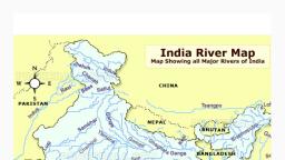
Indian river system
Page 2 :
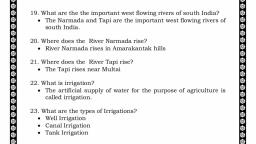
Types of river, As, , , , , , , categorised by K.L.Rao, Indian rivers are, three types according to size of their catchment, areas., Major river basin: Its catchment area is about, 20,000 sq.km., Medium river basin: Its catchment area is about, 2000-20,000 sq.km., Minor river basin: Its catchment area is less than, 2000 sq.km.
Page 3 :
Types of river, In, , India, depends upon resource &, origin can be devided into two main, groups., Himalayan Rivers., Peninsular Rivers.
Page 5 :
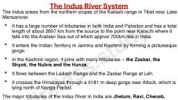
INDUS River
Page 7 :
INDUS River
Page 10 :
INDUS River, Indus, , water treaty, , Water distribution, , treaty between India and, , Pakistan., Signed, Treaty, , in Karachi on Sept 19, 1960., , allocates 80 % of water from the sixriver Indus water system to Pakistan.
Page 11 :
GANGES River
Page 19 :
GANGES River
Page 22 :
GANGES River, , , After entering Bangladesh, main branch of the Ganga is, known as Padma.
Page 24 :
GANGES River, Estuary and Delta –, o Estuary – Semi closed coastal body of water and it’s, connected to the open sea., o River Delta – A landform created by deposition of, sediment that is carried by a river.,
Page 25 :
GANGES River
Page 28 :
GANGES River, Sundraban Delta –, Bengal region of the Indian subcontinent –, Bangladesh & West Bengal., Name fron Sundari trees., World’s largest river Delta., Mangrove forest. Home of Royal Bengal, Tigers., o
Page 29 :
GANGES River
Page 33 :
GANGES River, , o, o, o, o, o, o, , Important facts about Ganga –, National river in India., Largest river system in India., Length of Ganga is 2,525 km (longest in India)., It is 34th longest river in the world by length., Ganga basin extends over as area of 10,86,000 sq.km., including Bangladesh., In India it covers about 8,62,769 sq.km. (neerly 26.2%, of the total geographical area of India).
Page 37 :
Tributaries of GANGES River, , o, o, o, o, , Right Bank Tributary of Ganges –, Yamuna, Tamas, Son, Punpun
Page 42 :
Chambal River Valley Project, , o, o, , , , o, , Chambal valley Project (dams) –, Joint venture of Rajasthan and M.P. Govt initiated, on1954., AimIrrigation, Power generation, Control of soil erosion., Executed in 3 stages., , Gandhi Sagar Dam
Page 45 :
Ken-Betwa River Project, Ken-Betwa River Project –, o To irrigate India’s worst drought, affected & drought prone, Bundelkhand region., o Main feature of the Project230 km long canal., o Will benefit 5 dist. of M.P, and 3 dist. of U.P,
Page 49 :
Tributaries of GANGES River
Page 50 :
Tributaries of GANGES River, , , Left bank tributaries of Ganga –
Page 55 :
Tributaries of GANGES River, , o, o, o, o, , o, , Ghaghara River –, Perennial, trans boundary., Source – Mapchachungo Glacier, near manasarovar, lake., It cuts through the Himalaya (Shivalik) in Nepal and, divides into Kauriala and Girwa rivers., Then rejoin south of the Indian border to form Ghaghara, River., Joins Ganga at Revelganj in Bihar.
Page 57 :
Tributaries of GANGES River, , o, o, , o, o, , o, o, o, , Ghaghara River _, Joined by Sharda River at brahmaghat (U.P), Sharda River (Kali/Mahakal/Kali Ganga) originated at, Uttarakhand-Tibet border and flows through Nepal, Border before joining at Ghaghara., Another tributary arising from Nepal-West Rapti., With a length of 507 km in Nepal, Ghaghara (Karnali) is, the longest river in Nepal., Largest & 2nd longest tributary of Ganga., Total length of Ghaghara river of 1080 km., Lower Ghaghara is also known as Sarayu river and is, mentioned in Ramayana (Aydhya is on it’s right bank).
Page 58 :
Tributaries of GANGES River, , o, o, o, o, o, o, , o, o, , Gandak river –, Trans boundary river., Origin –Nhubine Himal Glacier in the Mustang region, of Nepal (tibet border)., Here known as Kali Gandaki., One of the major rivers of Nepal., Enters India into Tarai region of Eastern U.P and Bihar., Joins Ganga at Sonpur (Bihar)., Mentioned in Mahabharata., Dhaulagiri is the highest point of the Gandaki Basin.
Page 63 :
Tributaries of GANGES River, , , Mahananda Rivero Trans Boundary river –, India & Bangladesh., o Origin – Darjeeling hills., o Flows through W.B and, Bihar and enters Bangladesh., o Joins Ganga at Godagiri,, Nawabganj dist,Bangladesh., o Easternmost tributary, arising from Himalaya.
Page 64 :
Thank you.