Page 1 :
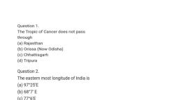
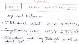
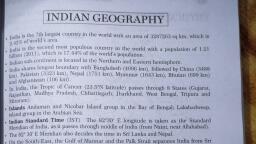
1-The length of north south extension of India (km)?, A-3314, B-3214, C-3233, 0-3124, , 2- The length of east west extension of India (km)?, A-2923, B-2933, C-2913, D-2943, , 3- What is the southern most point of India ?, A-Indira Ghat, , B-Pygmalion point, , C-The last point, , D-The end point, , 4-which is Country sharing longest boundary with India ?, , A-China, B-Pakistan, , C- Myanmar, D-Bangladesh, , 5-What is the eastern most point of India ?, , A-Kibithu, B-Dihang, C-Pongsto, D-Mikhir, , 6-What is the length of coastal area of India?, , 4-7436.16, B-7516.60, C-7506.16, D-7615.16, , 7-The southern most point of mainland India ?, A-Maheswaram, , B-Kanchipuram, C-Kanyakumari
Page 2 :
D-Nilagiri, &-The Tropic of cancer passes through which state ?, , A-Maharastra, B-Uttarakhanda, C-Uttarapradesh, D-Rajasthan, , 9-The Westem most point of India ?, , A-Guhar moti, B-Daman Diu, C-Kargir, , D- Jaisalemar, , 10-The IST Line passes through which states ?, , A-West Bengal, B-Bihar, C-Karnatak, D-Odisha, , 11. The northern most point of India ?, , A-Ladakh, B-Kashmir, C-Indira col, D-Indira point, , 12-The country with which India shared shortest boundary ?, , A-Bhutan, B-Nepal, C-Afghanistan, D-Pakistan, , 13- The Latitude of IST, , A-B3°1/2°E, B-82°1/2°E, C-81°1/2"E, D-82°1/3"E
Page 3 :
14-The no of states and UT share boundaries with other countries, , A-15, B-16, C+17, 0-18, , 15-The southern most latitude of India ?, , A-T*.45°N, B-6°45°N, , C-6°35"N, , D-8°4"N