Page 1 :
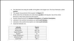
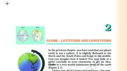
INDIA-SIZE AND LOCATION, Growth and progress of India, , ● India is one of the ancient civilizations in the world., ● It has achieved multi-faceted socio-economic progress during the last five decades., ● It has moved forward displaying remarkable progress in the field of agriculture, industry, technology and, overall economic development., ● India has also contributed significantly to the making of world history., Q. Briefly explain the growth and progress of India., , 3, , Latitudes/latitudinal lines, A. Definition: - It is an imaginary line which runs, parallel to the equator., B. It runs from east-west direction., C. There are total 180 latitude/latitudinal lines on the, globe. (90 latitudes north of equator and latitudes, south of equator), D. The largest latitude (largest circle) on the globe is 0°, i.e equator. As we go North ward or South word the, size (length) of latitudes decreases. So the smallest, latitude (smallest circles) on the globe is 90°N a nd 90°S, latitude., , E. The latitudes present in the north of equator are called, Northern latitude (indicated by 10N, 20N, 30N) and the, latitude present in the south of the equator is called, Southern latitude (indicated by 10S, 20S, 30S)., F. Moving South or North of the equator, the distance, between two latitudes never change, they always remain, parallel to each other., G. Important latitudes, 1., 2., 3., 4., 5., 6., 7., , 0° latitude is called Equator., 23° 30’N latitude is called Tropic of Cancer., 23° 30’S latitude is called Tropic of Capricorn., 66° 30’N latitude is called Arctic circle., 66° 30’S latitude is called Antarctic circle., 90°N latitude is called North pole., 90°S latitude is called South pole.
Page 2 :
H. Importance of latitudes/latitudinal lines, 1., , It helps in identifying the location of any place on the globe. For example, the location of India is 28°N, , latitude., (Q. From the map of South America find, Peru is located on which latitude? Q. Venezuela is located on which, latitude? Q. Find the latitude of Delhi. Q. Find the latitude of your hometown.), Country., , Capital. Lat. Log., , 2.It marks the boundary of different climatic regions on the globe. For example, Tropic of Cancer and Tropic of, Capricorn marks the boundary of hot and humid climate.
Page 3 :
Longitude, A. Definition: - It is an imaginary, semicircular line which runs from north to south., B. The Distance between two longitudinal lines remains wider near the equator. But the distance between two, longitudinal lines decreases as one moves towards the pole., C. Longitudinal lines are also called Meridian., D. There are total 360 longitudinal lines or meridians on the globe. (180, east of prime Meridian and 180, west of, prime Meridian), E. 0° longitude/meridian is called Prime Meridian. It passes through Greenwich, London., F. Prime Meridian divides the earth into two part the western part is called Western hemisphere and the eastern, part is called eastern hemisphere, G. Longitudes east of the prime Meridian is called eastern longitude (indicated by 10°E,20°E) and the longitude, west of the prime Meridian is called Western longitude (indicated by 10°W,20°W)., , H. 180°longitude/ Meridian is called international date line. It is not a straight line.
Page 4 :
I. Importance of longitude:● It helps in identifying the location., ● It helps in determining the time zone for a country., A. The location of point B is 60°North latitude and, 120° West longitude., , Location of India, 1. India is lying entirely in, the eastern part of, Northern hemisphere.
Page 5 :
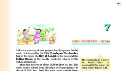
2. The mainland extends between (latitudes 8°4’N and 37°6’N) and (longitudes 68°7’E and 97°25’E)., , 3. The Tropic of Cancer (23° 30’N) divides the country into almost two equal parts., 4. To the southeast and southwest of the mainland, lie the Andaman and Nicobar Islands and the Lakshadweep, islands in Bay of Bengal and Arabian Sea r espectively., 5. The southernmost point of the Indian Union– ‘Indira Point’ got submerged under the sea water in 2004 during, the Tsunami., Try, if you can, Q. Which latitude divides India into two equal halves?, Name it and also mention its latitudinal degree. 1, Q. Tropic of Cancer passes through how many states of, India? 1, Q. Arrange the following states in sequence from west to, east, through which the Tropic of Cancer passes. 1, Q. The mainland of India extends between which, longitudes and which latitudes (mention the degree of, latitudes and longitudes)?, 1, (Chhattisgarh, Mizoram, Gujarat, West Bengal,, Rajasthan, Madhya Pradesh, Jharkhand, Tripura), Q. Which southernmost point of the Indian Union got, submerged under the sea water in 2004 during the, Tsunami?, Q. Briefly explain the location of India. 3, , Size, ● The land mass of India has an area of 3.28 million square km., ● India’s total area accounts for about 2.4 per cent of the total geographical area of the world., ● India is the seventh largest country of the world.
Page 6 :
● India has a land boundary (coastal+non- coastal) of about 15,200 km., ● The total length of the coastal boundary or coastline of the mainland, including Andaman and Nicobar and, Lakshadweep, is 7,516.6 km. (Calculate, what will be the non-coastal boundary of India?), Q. How much is the area of the land mass of India? 1, Q. India’s total area accounts for what percent of the total, geographical area of the world? 1, Q. What is the rank of India in size?, 1, Q. How much is the total land boundary of India? 1, Q. How much is the coastal boundary of India including the, Islands? 1, Q. Briefly explain about the size of India. 3, Q. Name the countries which are larger than India. 1, , Frontiers of India, ● India is bounded by the young fold mountains in the northwest,, north and northeast., ● It is a bounded by Indian Ocean from South which is further divided, into two seas, the Arabian Sea on the west and the Bay of Bengal, on its east., , Interesting fact about India, Fact number 1, , The mainland extends between (latitudes 8°4’N and 37°6’N) and (longitudes 68°7’E and 97°25’E)., So, if we try to calculate the difference between the northernmost latitudes and the southernmost latitude of, India. We find that there is a difference of almost 30° latitudes. (37°-8°=29°), Similarly, if we try to calculate the difference between easternmost longitude and the westernmost longitude, of India. We find that there is a difference of almost 30-degree longitudes. (97°-68°=29°), It means, that the latitudinal and longitudinal extent of the mainland is equal i.e about 29°~ 30°., But if we measure the actual distance between (easternmost-westernmost point) and, (northernmost-southernmost point). We will observe that the east-west extent (which is 2933 km) appears to be, smaller than the north-south extent (which is 3214 km).
Page 7 :
Q. How much is the distance between easternmost, and westernmost part of India? 1, Q. How much is the distance between southernmost, and the northernmost part of India?, , 1, , Q. How much is the approx latitudinal and, longitudinal gap between north-south and east-west, extent of India?, , 1, , Q. Briefly explain about the the natural boundary or, the natural Frontier of India. 3, , Effects of longitudinal extent of India, There is a gap of 2933 km between easternmost and the westernmost point. Sun rays first falls on the, eastern part of India and then it gradually travels to the western part of India. Sun rays almost takes 2 hours to, travel from easternmost part of India to westernmost part. In simple terms, days starts 2 hrs earlier in the eastern, part of India then the western part of India., In another words,we can say that due to longitudinal extent of India, from Gujarat to Arunachal Pradesh, there, is a time lag of two hours.
Page 8 :
If we would have been following the time as per the sunrise, then there would have been lot of time, confusion., So, to overcome the problem of this time confusion or a time gap, we chose one Indian standard time from, the standard Meridian of India i.e (82°30’E). This Standard Meridian of India (82°30’E) passing through Mirzapur, (in Uttar Pradesh)., , Effects of latitudinal extent of India, The latitudinal extent influences the duration of day and night, as one moves from south to north. That is why the, difference between the durations of day and night is felt in Kashmir but not in Kanyakumari., Q. Mention the effect of latitudinal and longitudinal extent of India. 3, Q. From Gujarat to Arunachal Pradesh, there is a time lag of how many hours? 1, Q. From Gujarat to Arunachal Pradesh, there is a time lag of how many hours? What India did to overcome the, problem of this time lag? 3, Q. Why India opted for one Indian standard time?, 3, Q. How much is the longitude degree of standard Meridian of India? 1, Q. The standard Meridian of India passes through which is city of which state? 1, Q. The sun rises two hours earlier in Arunachal Pradesh as compared to Gujarat in the west, but the watches show, the same time. How does this happen? 3, , Importance of India's location, ● The Indian landmass has a central location between the East and the West Asia., ● No other country has a long coastline on the Indian Ocean as India has., Importance, , ● The trans Indian Ocean routes, provide a strategic central location to India. (The trans Indian Ocean routes, connect the countries of Europe in the West and the countries of East Asia), ● The Deccan Peninsula extension into the Indian Ocean, is helping India to establish close contact with West, Asia, Africa and Europe from the western coast and with Southeast and East Asia from the eastern coast., ● It is India’s eminent position in the Indian Ocean, which justifies the naming of an Ocean after it., Q. It is India’s eminent position in the, Indian Ocean, which justifies the, naming of an Ocean after it. Justify, the statement., 3, Q. India occupies an important, strategic position in South Asia., Justify this statement with suitable, example. 3/5, Q. The location of India is very, suitable for trade. Justify this, statement. 3, Q. Why Indian ocean has been named, after India?, 3, Q. Mention any three importance of, location of India at its place. 3, Q. The central location of India at the, head of the Indian Ocean is, considered of great significance., Why? 3
Page 9 :
India’s contacts with the World, India’s contacts with the World have continued through ages but her relationships through the land routes are, much older than her maritime contacts. Various evidences prove the given statement. Following are the evidences, ● The various mountain passes across the mountains in the north have provided passages to the ancient, travellers., ● These routes have contributed in the exchange of ideas and commodities since ancient times., ● The ideas of the Upanishads and the Ramayana, the stories of Panchtantra, the Indian numerals and the, decimal system thus could reach many parts of the world., ● The spices, muslin and other merchandise were taken from India to different countries., ● On the other hand, the influence of Greek sculpture, and the architectural styles of dome and minarets, from West Asia can be seen in different parts of our country., Q. India’s contacts with the World have continued through ages but her relationships through the land routes are, much older than her maritime contacts. Justify this statement with examples., 5, Q. The ancient Indian routes have contributed in the exchange of ideas and commodities with the world, since, ancient times. Justify the statement with suitable example. 3, , India’s Neighbors, ● India has 28 states and 9 Union Territories., ● India shares its land boundaries with (Pakistan and Afghanistan in the northwest), (China (Tibet), Nepal and, Bhutan in the north) and (Myanmar and Bangladesh in the east)., ● Our southern neighbours across the sea consist of the two island countries, namely Sri Lanka and Maldives., ● Sri Lanka is separated from India by a narrow channel of sea formed by the Palk Strait and the Gulf of, Mannar., ● Maldives Islands are situated to the south of the Lakshadweep Islands., Q. Name the southern neighbors of, India. 1, Q. Sri Lanka is separated from India, by which narrow channel?, , 1, , Q. Mention the name of the, neighboring countries, India has in, its North, Northwest and East., , 1, , Q. Name the group of islands lying, in the Arabian Sea. 1, Q. Which island group of India lies, to its south-east? 1, Q. Which island countries are our, southern neighbors?, , 1
Page 10 :
Exercise, 1. Choose the right answer from the, four alternatives given below :, (i) The Tropic of Cancer does not pass, through:, (a) Rajasthan, (b) Chhattisgarh, (c) Orissa, (d) Tripura, ► (c) Orissa, 2. The eastern-most longitude of India, is:, (a) 97°25′E, (b) 68°7′E, (c) 77°6′E, (d) 82°32′E, ► (a) 97°25′E, 3. Uttarakhand, Uttar Pradesh, Bihar,, West Bengal and Sikkim have common, frontiers with :, (a) China, (b) Bhutan, (c) Nepal, (d) Myanmar, ► (c) Nepal, 4. If you intend to visit the island, Kavaratti during your summer, vacations, which one of the following, Union Territory of India you will be, going to?, (a) Pondicherry, (b) Andaman and Nicobar, (c) Lakshadweep, (d) Diu and Daman, ► (c) Lakshadweep, 5. My friend hails from a country, which does not share land boundary, with India. Identify the country., (a) Bhutan, (b) Tajikistan, (c) Myanmar, (d) Nepal, ► (b) Tajikistan, , 2. Answer the following questions briefly., (i) Name the group of islands lying in the Arabian Sea., (ii) Name the countries which are larger than India., (iii) Which island group of India lies to its south-east?, (iv) Which island countries are our southern neighbours?, Answer, (i) Lakshadweep, (ii) Russia, Canada, China, USA, Brazil and Australia., (iii) Andaman and Nicobar group of islands., (iv) Maldives, Sri Lanka., 3. The sun rises two hours earlier in Arunachal Pradesh as compared to, Gujarat in the west but the watches show the same time. How does this, happen?, Answer, The longitudinal gap between Arunachal Pradesh and Gujarat is about 30°., Due to this, there is time lag of about two hours between these states., Since Arunachal Pradesh is in the east hence the sun rises earlier here, compared to in Gujarat. The Indian Standard Time is taken from the time, of Standard Meridian of India and hence the watches show the same time, in both the states., 4. The central location of India at the head of the Indian Ocean is, considered of great significance. Why?, Answer, The central location of India at the head of the Indian Ocean is considered, of great significance because → It has given India a strategic advantage due to the Trans Indian ocean, routes which connect the countries of Europe in the West and the, countries of East Asia., → This helps India to establish close contact with West Asia, Africa and, Europe from the Western coast and with the Southeast and East Asia from, the Eastern coast., → The vast coastline and the natural harbours have benefitted India in, carrying out trade and commerce with its neighbouring and distant, countries since ancient times., → It has given India a distinct climate than the rest of the Asian Continent., → No other country has such a long coastline on the Indian Ocean as, India. It is India’s eminent position in the Indian Ocean which has given, the name of an Ocean after it.
Page 11 :
Map Skills, 1. Identify the following with the help of, map reading., (i) The island groups of India lying in the, Arabian Sea and the Bay of Bengal., (ii) The countries constituting Indian, Subcontinent., (iv) The states through which the Tropic, of Cancer passes., (iv) The northernmost latitude in, degrees., (v) The southernmost latitude of the, Indian mainland in degrees., (vi) The eastern and the western most, longitudes in degrees., (vii) The place situated on the three, seas., (viii)The strait separating Sri Lanka and, India., (ix) The Union Territories of India., Important map work in syllabus, ● India - States with Capitals, ● Tropic of Cancer(with States), ● Standard Meridian (Location and, Labeling), , Answer, (i) Lakshadweep, (ii) Countries which make the Indian subcontinent are Pakistan in the, north-west, India at the core, Nepal in the north, Bhutan in the, north-east and Bangladesh in the east., (iii) Tropic of Cancer passes through the states of Gujarat, Rajasthan,, Madhya Pradesh, Chhattisgarh, Jharkhand, West Bengal, Tripura and, Mizoram., (iv) 37°6' N, (v) 8°4' N, (vi) Western - 68°7' E, Eastern - 97°25' E, (vii) Kanyakumari, (viii) The Palk Strait., (ix) Andaman and Nicobar Islands, Chandigarh, Dadra and Nagar Haveli,, Daman and Diu, Delhi, Lakshadweep, Puducherry (Pondicherry)., , 1. Why 82°30'E has been selected as the, Standard Meridian of India?, 82°30' E has been selected as the, Standard Meridian of India because it is, situated in the centre of all longitudes, and latitudes in which our country is, located., 2. Why is the difference between the, durations of day and night hardly felt at, Kannyakumari but not so in Kashmir?, The difference between the durations of, day and night hardly felt at Kannyakumari, because it is near equator. As equator, recieves the direct Sun rays, there won't, be hardly any difference between the day, & night. But the Kashmir is far away from, equator.
Page 12 :
Extra questions, 1. The number of Union Territories along the western and eastern coasts., Union Territories on the western coast of India are — Diu and Daman, Dadra and Nagar Haveli, Mahe, (Pondicherry) and Lakshadweep., Union Territories on the eastern coast of India are — Pondicherry and Andaman and Nicobar Islands., 2. Area-wise which is the smallest and which is the largest state?, Largest Sate: Rajasthan, Smallest State: Goa, 3. The states which do not have an international border or lie on the coast., Haryana, Madhya Pradesh, Chhattisgarh, Jharkhand, Telangana., 4. Classify the states into four groups each having common frontiers with, (i) Pakistan (ii) China (iii) Myanmar and (iv) Bangladesh., Answer, (i) States having common frontiers with Pakistan are Jammu and Kashmir, Punjab, Rajasthan., (ii) States having common frontiers with China are Jammu and Kashmir, Himachal Pradesh, Uttarakhand, Sikkim, and Arunachal Pradesh., (iii) States having common frontiers with Myanmar are Arunachal Pradesh, Nagaland, Manipur., (iv) States having common frontiers with Bangladesh are Meghalaya, Assam. West Bengal, Tripura., Q.Identify the countries constituting the Indian subcontinent., Ans. 1. India in the center, 2. Pakistan in North-west, 3. Nepal in the North, 4. Bhutan in North-east, 5. Bangladesh in east, Q.Why is India called a sub-continent?, Ans. India and the adjoining countries are considered to be a sub-continent as it, comprises of all the characteristics of a continent., ● Indian sub-continent encompasses vast areas of diverse landmasses. Indian subcontinent comprises of lofty, mountains, fertile plains, desert and plateau., ● There is also great vastness and diversities in terms of climate, natural vegetation,, wildlife and other resources., ● Also, the vivid characteristics of culture and tradition among the people make it a, subcontinent., Q.How do we calculate the time difference from Arunachal Pradesh to Gujarat?, Ans. Sun rays take 4 minutes to cover one longitude., From Arunachal Pradesh to Gujarat there are 30 longitudes (68°7´E to 97°25´E), Calculation, Time taken by light to cross a longitude = 4 min, Time taken by light to cross 30 longitudes = 4X30= 120 min or 2 hours., Hence, we can say that the time difference of 2 hours exists from Arunachal, Pradesh to Gujarat.