Notes of UPSC BATCH 2024, Upsc River 1.pdf - Study Material
Page 1 :
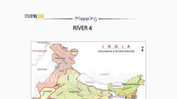
STUDYIO.C0W, , , , Mapping, RIVERS PART 1, , The Indian Drainage System, + Itis an outcome of:, * The evolutionary process of the three major physiographic units, , * The nature and characteristics of precipitation., , Classification of Drainage Systems in India, , * On the basis of discharge of water (orientations to the sea), the drainage system of India, may be grouped into:, , * the Arabian Sea drainage, * the Bay of Bengal drainage, * They are separated from each other by the Delhi ridge, the Aravalis and the Sahyadris., , + Nearly 77 percent of the drainage area consisting of the Ganga, the Brahmaputra, the, Mahanadi, the Krishna, etc. is oriented towards the Bay of Bengal, , * while 23 percent comprising the Indus, the Narmada, the Tapi, the Mahi and the Periyar, systems discharge their waters in the Arabian Sea., , , , 5
Page 2 :
STUDYIQ.COW, , , , Mapping, , ss On,, me ON INDIA N, , Mee ey MAJOR RIVERS, , fie }, , ~* :, , x, ff,, , , , , , , cuina, (Tiger), , Range, , 20°, , ARABIAN, , SEA BENGAL, , ~~ Water Divide + soe, , , , UKSHADWeEP, Nou), , , , , , INDIAN, , Classification On the basis of the mode of origin, nature and characteristics, * The Himalayan drainage, * The Peninsular drainage., , * There is no clear-cut line of demarcation between these two drainage systems, as many, of the peninsular rivers like the Chambal, Betwa, Sind, Ken and Son are much older in age, and origin than the Himalayan rivers., , The Himalayan Drainage system, , * It consists of the rivers originating in the Himalayan and trans-Himalayan region. It, further consists of three river systems namely:, , * the Ganga,, * the Indus, and, , * the Brahmaputra river systems., , 2)
Page 3 :
STUDYIO.C0W, , Mapping, , Since these are fed both by the melting of snow and precipitation, rivers of this system, are perennial. The various geographical features made by the Himalayan rivers are:, , , , In upper reaches (Youthful stage): Gorges, V-shaped valleys, rapids, waterfalls, truncated, spurs etc., , In plain areas or middle part (Mature stage): While entering the plains, they form, depositional features like flat valleys, ox-bow lakes, flood plains, braided channels, and, deltas near the river mouth. Over the plains, they display a strong meandering tendency, and shift their courses frequently., , 1, Upper Course 2. Middle Course 3. Lower Course, , , , , , , , , , , , , , , , , , Channel / Valley Cross Se¢tion, , i, , , , , } Decreasing Gradient} :, i Mature: Old, Ty, WPertation i, Predominantly i }, Eroenon i {* __ Lots of Deposition, , , , , , i Lateral Erosion : Alluvium Deposition, Vertical Erosion (Valley Widening), (Cutting Down) : ;, River characteristics, , Since these are fed both by melting of snow and precipitation, rivers of this system are, perennial., , These rivers pass through the giant gorges carved out by the erosion activity carried on, simultaneously with the uplift of the Himalayas., , , , 5
Page 4 :
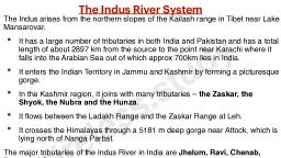
STUDYIO.C0W, , , , Mapping, , Besides deep gorges, these rivers also form V-shaped valleys, rapids and waterfalls in, their mountainous course., , While entering the plains, they form depositional features like flat valleys, ox-bow lakes,, floodplains, braided channels, and deltas near the river mouth., , In the Himalayan reaches, the course of these rivers is highly tortuous, but over the, plains, they display a strong meandering tendency and shift their courses frequently., , The Indus river system, , It is one of the largest river basins of the world., , A little over one-third of the Indus basin is located in India; in the states of Jammu &, Kashmir, Himachal Pradesh and Punjab. The rest of the portion is in Pakistan., , The Indus also known as the Sindhu, is the westernmost of the Himalayan rivers in India., , Origin: It originates from a glacier near Bokhar Chu in the Kailash Mountain range, (Tibetan region). In Tibet, it is known as ‘Singi Khamban; or Lion’s mouth, It enters India in, the Ladakh district of Jammu & Kashmir., , The river-course:, * The Indus cuts through Himalayas and enters India near Damchok., * — flows in India only through the Leh district in Jammu and Kashmir., , * — It enters into Pakistan near Chillar in the Dardistan region through a deep gorge near, the hair-pin bend of Nanga Parbat., , + It finally discharges into the Arabian Sea, east of Karachi., , Zaskar, Nubra, Shyok and Hunza are the main tributaries which join the Indus in Kashmir, region., , Sutlej, Beas, Ravi, Chenab and Jhelum join together and enter the Indus near Mithankot, in Pakistan., , The left-bank tributaries of Indus:, o Zaskar, , © ‘Panjnad’ joins Indus a little above Mithankot). The Panjnad is the name given to the, five rivers of Punjab, namely:, , ©. Satluj, , , , 5
 Learn better on this topic