Notes of 3rd Sem, Advanced Surveying 22301-syllabus.pdf - Study Material
Page 1 :
Advanced Surveying Course Code: 22301, , , , Program Name : Civil Engineering Program Group, Program Code : CE/CR/CS, , Semester : Third, , Course Title : Advanced Surveying, , Course Code 222301, , 1. RATIONALE, , In the era of globalization today, the technology has brought the significant advancements in, surveying instruments and technology. Available precise digital surveying instruments are, used currently due to their accuracy, speed and easy operation of the same. These equipments, and the applications are extensively used in the fields of civil engineering, mining, engineering, environmental engineering, transportation engineering and marine engineering., Since, Remote sensing and Geographic Information System (GIS) is a vital discipline and, being widely used for plotting and storing spatial information, it is expected the students, should know the basics of the same to apply it in field. Through this course students will, develop the desired skills and competencies which are expected from them for survey related, works., , 2. COMPETENCY, The aim of this course is to help the student to attain the following industry identified, competency through various teaching learning experiences:, e Prepare plans, contour maps using Advanced Surveying equipment and, techniques., , 3. COURSE OUTCOMES (COs), , The theory, practical experiences and relevant soft skills associated with this course are to be, taught and implemented. so that the student demonstrates the following industry oriented, COs associated with the above mentioned competency:, , Prepare plans using Plane Table Surveys., , Prepare plans using Theodolite surveys., , Find distances and elevations using Tacheometer., , Set out simple circular curves., , Prepare plans using Total Station instrument., , Locate coordinates of stations using GPS., , oh Go) DP, , 4. TEACHING AND EXAMINATION SCHEME, , jeanne Examination Scheme, iu eee Practical, L|T|P| P) Pap ESE Total PA Total, ivs, Max| Min | Max | Min | MaxiMin | Max | Min | Max | Min | Max | Min, 3/-|4] 7 3 | 70 | 28 oo |100| 40 | so# | 20 | so | 20 | 100 | 40, , (*): Under the theory PA, Out of 30 marks, 10 marks are for micro-project assessment to, facilitate integration of COs and the remaining 20 marks4 verage of 2 tests to be taken, , , , , , MSBTE - Final Copy Dt. 20.04.2018 Page I of 10
Page 3 :
Advanced Suyeying, , Course Code: 22301, , , , , , , , , , , , , , , , , , , , , , , , , , , , , , , , , , , , , , , , , , , , , , , , , , , , , , , , , , , , , , MSBTE - Final Copy Dt. 20.04.2018, , , , , , , , , , , , , , , , 5. Practical Outcomes (PrOs) Unie, No. No. :, — —— __|_| Required, ] Use Plane Table Survey to prepare plans of a 5 sided closed I O2*, | traverse by Radiation Method. |, 2 Use plane table survey to prepare plans ofa plot of 7 sided closed I 02, traverse by Radiation Method., 3 | Use plane table survey to prepare plans locate details | by | I 02*, Intersection Method, 4 Use plane table survey to prepare plans locate details by Traversing | 1 02*, __| Method {jo, 5 Use plane table survey to carry out Survey ey Project fo for closed | I Full day*, traverse for minimum 5 sides around a building.(Compulsory) J, 6 Set up the transit Theodolite i 020, 7 Use transit theodolite to measure Horizontal angle correctly by | by I 02*, Direct Method. __ | |, 8 Use transit theodolite to measure Vertical angle correctly by Direct II 02*, Method. a, 9 Use transit theodolite to measure Horizontal angle correctly by II 02*, method of Repetition., 10 | Use transit theodolite to measure Vertical angle correctly by I 02, method of Repetition, [11 | Use transit theodolite to carry out Survey Project for closed Il Full day*, traverse for minimum 5 sides(Compulsory)., 12 | Plot the traverse on AI size imperial drawing sheet for the Il 02*, collected data from preceding Theodolite Survey Project., 13 | Plot the traverse on A1 size imperial drawing sheet for the Il 02*, collected data from preceding Theodolite Survey Project., 14 | Use thedolite as a Tacheometer to compute reduced levels and Il 02*, horizontal distances. —, 15__| Set outa circular curve by offsets from Long Chord Method. IV 02*, 16 _| Set out a circular curve by Rankine’s Method of Deflection Angles. |_ IV 02,, 17. | Use One Second Micro Optic Theodolite to Measure Horizontal Vv 02, angle by Direct Method —, 18 | Use One Second Micro Digital Theodolite to Measure Horizontal Vv 02, angle by Direct Method - - |, 19 | Use EDM to measure horizontal distance.(Partl) Vv 02*, 20 | Use EDM to measure horizontal distance(Part 11) Vv 02, 21 | Set up the Total Station instrument. (Partl) Vv 02*, 22__| Set up the Total Station instrument. (Part II) _ Vv 02, 3__| Use Total station instrument to measure horizontal distances. __ iy —02*, 24 | Use Total station instrument to measure horizontal distances. | Vv 02, 25 | Use Total station instrument to measure horizontal distances. Vv 02, 26 | Use Total station instrument to measure horizontal distances. | ve 02, 27 _| Use Total station instrument to measure horizontal angle, oe Vv 02*, 28 | Use Total station instrument to measure horizontal angle. Vv 02, 29 | Use Total station instrument to measure horizontal angle. Vv 02, 30 | Use Total station instrument to measure vertical angle. Zoe EG Sav __ 02*, , tn Page 3 of 10, eg
Page 4 :
Advanced Surveving Course Code: 22301, , , , r — — — —, , , , , , 7 ya | Approx. |, | 5 Practical Outcomes (PrOs) Unit Hrs, No. No. “, — = —_ __ Required, | 31 | Use Total station instrument to measure vertical angle. v 02, | 32. | Use Total station instrument to carry out Survey Project for closed V_ | Full day*, | traverse for minimum 5 sides.(Compulsory) 7, 33 | Plot the traverse on Al size imperial drawing sheet for the Vv 02*, |__| collected data from preceding Total Station Survey Project., 34 | Plot the traverse on Al size imperial drawing sheet for the 02*, collected data from preceding Total Station Survey Project., 35__| Use GPS to locate the coordinates of a station. VI Q2*, Total —_ 64 |, Note, , i. A suggestive list of PrOs is given in the above table. More such PrOs can be added to, attain the COs and competency. A judicial mix of minimum 24 or more practical, LOs/tutorials need to be performed, out of which, the practicals marked as ‘*’ are, compulsory, so that the student reaches the ‘Precision Level’ of Dave’s ‘Psychomotor, Domain Taxonomy’ as generally required by the industry., , ii, Hence, the ‘Process’ and ‘Product’ related skills associated with each PrO of the, laboratory/vorkshop/field work are to be assessed according to a suggested sample given, , below:, , _S.No. Performance Indicators a \ Weightagein% |, | 1 Preparation of experimental set up oe a 10, , 2 | Setting and operation oe | 20, , 3 Safety measures | 10, , 4 Observations and Recording — | 20, , 5 Interpretation of result and plotting. | 20, , 6 Answer to sample questions 10, , 7 Submission of report in time 10, , Total | 100, , The above PrOs also comprise of the following social skills/attitudes which are Affective, Domain Outcomes (ADOs) that are best developed through the laboratory/field based, experiences:, , Follow safety practices., , Practice good housekeeping., , Demonstrate working as a leader/ team member., , Maintain tools and equipment., , Follow ethical Practices., , PRoaFPp, , The ADOs are not specific to any one PrO, but are embedded in many PrOs. Hence. the, acquisition of the ADOs takes place gradually in the student when s/he undertakes a series of, practical experiences over a period of time. Moreover, the level of achievement of the ADOs, according to Krathwohl’s ‘Affective Domain Taxonomy’ should gradually increase as planned, below:, , e ‘Valuing Level’ in 1“ year, , © ‘Organising Level’ in 2" year, , ® ‘Characterising Level’ in 3" year., , , , MSBTE - Final Copy Dt. 20.04.2018 Page 4 of 10
Page 5 :
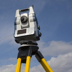
Advanced Surveying, , Te, , Course Code: 22301, , MAJOR EQUIPMENT/ INSTRUMENTS REQUIRED, , The major equipment with broad specification mentioned here will usher in uniformity in, conduct of experiments, as well as aid to procure equipment by authorities concermed., , , , , , , , , , , , , , , , , , , , , , , , , , , , , , , , aa Equipment Name with Broad Specifications a =, , 1 Plane table with accessories- Plane and telescopic Alidade, Trough compass, 1-5, |_| U-fork Spirit level. ee, , 2 | Twenty Second Transit theodolite with accessories. _, , 3 | One second Micro optic Theodolite with accessories,, , 4 Electronic Digital Theodolite with accessories., 15 | E Electronic Distance meter (For- 2mm accuracy) with accessories., 6 ‘Total Station (+ or - 2mm accuracy) instrument with accessories 7 | | GPS ins nstrument, , 8. UNDERPINNING THEORY COMPONENTS, , The following topics are to be taught and assessed in order to develop the sample UOs given, below for achieving the COs to attain the identified competency. More UOs could be added., , , , , , , , , , , , Unit Unit Outcomes (UOs) Topics and Sub-topics, (in cognitive domain), Unit -I ja. Explain the functions and use of 1.1 Principle of plane table survey., Plane the given accessories of plane 1.2 Accessories of plane table and their, Table table. use, Telescopic alidade., Surveying | 1b. Describe the method of orienting 1.3 Setting of plane table; Orientation, the plane table in a given situation. of plane table - Back sighting and, Ic. Select the method of plane tabling Magnetic meridian method, True, for a given situation. Meridian Method, 1d. Compare the given two methods of | 1.4 Methods of plane table surveysdoing plane table survey. Radiation, Intersection and, Traversing., 1.5 Merits and demerits of plane table, survey., Unit- I 2a. Explain the given components ofa 2.1 Types and uses of Theodolite;, Theodolit transit Theodolite Component parts of transit, e 2b. Describe the salient features and Theodolite and their functions,, Surveying the relationship between the given Reading the Vernier of transit, fundamental axes. Theodolite,, 2c. Describe the procedure to measure 2.2 Technical terms- Swinging,, the horizontal and vertical angles Transiting, Face left, Face right,, using Theodolite for the given 2.3. Fundamental axes of transit, situation. Theodolite and their relationship, 2d. Apply checks for determining the 2.4 Temporary adjustment of transit, type of traverse using the given Theodolite,, data. 2.5 Measurement of horizontal angle2c. Compute Latitude, Departure, Direct and Repetition method,, Consecutive co ordinates. Errors eliminated by method of, Independent coordinates from tl z _, , , , MSBTE - Final Copy Dt. 20.04.2018, , , , , , , , , , Page 5 of 10
 Learn better on this topic