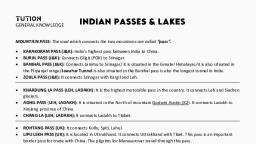
Notes of WBCS(Exe) 2022, GENERAL STUDIES Important Passes Of India. - Study Material
Page 2 :
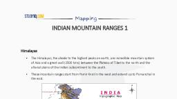
What is a pass?, , A mountain pass is a navigable route through a mountain range or over a ridge. Passes have played a key role in trade,, war, and both human and animal migration throughout history., , Passes are found in mountain areas only, Therefore in India passes are generally found in Ladakh, Jammu and, Kashmir, Himachal, Uttarakhand, Sikkim, Arunachal Pradesh. But passes are also present in areas of Western Ghats, (Maharashtra, Kerala)., , * ‘La’ means ‘pass’., , , , , , , , , , , , , , , , , , , , Mountain Passes in Ladakh Pes a ae, e Khardung La we oe, © Zoji La Lv “PAshiepass, e Pensi La “Se twey AlQara Pass, > f v, ¢ Taglang La oN IMRarakoram Pass ,, e Chang La Forse ', e Lanak La uf? [Burzi Pass [|Khardung La Pads, e Imis La { * i =, e = Aghil Pass \ _[[Poita Pass Il chante Pi Snak La Pass, e Fotu La a, e@ = Namika La || Tanglarig La, e@ = Marsimik La ‘, e Karakoram Pass, e@ = Qara pass, Khardung La, e Khardung La is a mountain pass in the Leh district of the Indian union territory of Ladakh., e The pass on the Ladakh Range is north of Leh and is the gateway to the Shyok and Nubra valleys. [Col Chewang, Rinchen Setu bridge is on Shyok river, Nubra river is formed with melting of Siachen Glacier], e Maintained by the Border Roads Organisation, the pass is strategically important to India as it is used to carry supplies, to the Siachen Glacier., e = The elevation of Khardung La is 5,604 m (18,380 ft)., e Itis the highest motorable road in the World., Zoji La, e = Zoji La is a high mountain pass in the Himalayas in the Indian union territory of Ladakh., e Located in the Drass, the pass connects the Kashmir Valley to its west with the Drass and Suru valleys to its northeast, and the Indus valley further east., e@ The National Highway | between Srinagar and Leh in the western section of the Himalayan mountain range traverses, the pass., e@ = =Zoji La Tunnel is a 14.2 km long road tunnel under Zoji La pass in the Himalayas between Sonmarg and Drass town in, Kargil district of the Indian Union Territory of Ladakh, currently, under construction. e nag, e = The tunnel along with 6.5 km long Z-Morh Tunnel, (which is 22 km \“ _, before Zoji La tunnel towards Srinagar) will ensure year-long road > ‘ Aa, connectivity between Srinagar and Kargil which currently remains ona) tat v, closed for about seven months due to heavy snowfall on the Zoji La ey $, pass. G p cs ;, lamabad eer, bul git " Pensi La ¥, Pensi La ‘© Zanskar, e Pensi-la (Pensi Pass) is a mountain pass in the Ladakh union territory ~ my ¢, of India, which is known as the Gateway to Zanskar. - " ete, e Pensi La is 4,400 m (14,436 ft) above sea level and connects the Suru | Amjad ie HIMACH :, Valley region to the Zanskar Valley region. PAS ed 1S A {, , , , , , , , , , © Copyright 2020 Study |Q
Page 3 :
5 High Altitude Himalayan Passes on the Manali-Leh Highway!, , 1,, , Rohtang La (Himachal Pradesh), , 2. Baralacha La (Himachal Pradesh - Ladakh border), 3. Nakee La (Ladakh), 4. Lachulung La (Ladakh), 5. Taglang La (Ladakh), Taglang La, , e Taglang La or Tanglang La, elevation 5,328 metres (17,480 ft), is a, , high altitude mountain pass in the Indian union territory of Ladakh., , e Itis traversed by the Leh-Manali highway. During winters, it’s, , almost impossible to cross this road., Chang La, , e@ The Chang La is a high mountain pass in Ladakh at an elevation of, 5,360 m or 17,590 ft., , e@ Chang La is approached from Leh via Kharu and Sakti village by an, asphalt road., , e@ The Chang La is on the route to Pangong Lake from Leh. (Pangong, Tso is 1/3rd in India and 2/3rd in China), , e The Changla Pass is the main gateway for the Changthang Plateau, situated in the Himalayas., , e@ The world's highest research station, established by the Defence, , Research and Development Organisation is functional in Chang La at, a height of 17,664 ft., , , , Leh,, , , , eS, , Pangong-Tso, \, , , , , , , , , , The Lanak La or Lanak Pass, , , , , , Leh:, , , , , , Hemis, National Park, , Taglang La, , Lachulung La 5065 m, Nakee La 4739 nf), , Baralacha La Pass, , , , , , , , , , , , , , e It is a mountain pass in the disputed Aksai Chin region, administered by China as part of the Tibet Autonomous, Region. It is claimed by India as its border pass., e Lanak La had been a well-established frontier point between Ladakh and Tibet, as confirmed by travellers from, William Moorcroft in 1820 onwards., e Several travellers wrote in the late 19th and early 20th centuries that the traditional boundary between India and Tibet, was at Lanak La., LW AMMUJAND™ sOLeh i, Imis La KASHMIR <, e Imis La is an international high mountain pass at an elevation of 5.290m ste - we, (17,355ft) above the sea level, located between Ladakh (India) and Tibet, (China). yw, e Itis one among the major passes over the main Himalayan Range. A Ap, \. ‘Olmis La, HIMACHAL “Ye PRADESH, Aghil Pass Uae = &, e = Itis situated to the North of Mount Godwin-Austen in the Karakoram., e It connects Ladakh with the Xinjiang province of China. It remains closed during the winter season from November to, May., 3 © Copyright 2020 Study IQ
 Learn better on this topic